Lolo, Montana facts for kids
Quick facts for kids
Lolo, Montana
|
|
|---|---|
 |
|
| Nickname(s):
(Salish: čkʷlkʷqin )
|
|

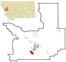
Location in Missoula County and the state of Montana. Grey shading indicates city of Missoula.
|
|
| Country | United States |
| State | Montana |
| County | Missoula |
| Area | |
| • Total | 9.63 sq mi (24.95 km2) |
| • Land | 9.46 sq mi (24.50 km2) |
| • Water | 0.17 sq mi (0.45 km2) |
| Elevation | 3,199 ft (975 m) |
| Population
(2020)
|
|
| • Total | 4,399 |
| • Density | 464.96/sq mi (179.52/km2) |
| Time zone | UTC-7 (Mountain (MST)) |
| • Summer (DST) | UTC-6 (MDT) |
| ZIP code |
59847
|
| Area code(s) | 406 |
| FIPS code | 30-44650 |
| GNIS feature ID | 0786464 |
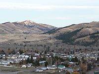
Lolo is a small community in Missoula County, Montana, USA. It is considered a census-designated place, which means it's a special area defined for gathering population data. Lolo is part of the larger Missoula area.
In 2020, about 4,399 people lived in Lolo. This was an increase from 3,892 people in 2010. Lolo is famous for Travelers' Rest State Park. This park is where the famous explorers Lewis and Clark camped long ago. They stayed there in 1805 and again in 1806.
Contents
History of Lolo, Montana
The Travelers' Rest site in Lolo is very special. It is one of the few places in the United States where we have real proof that Lewis and Clark visited. This proof includes physical evidence from their time there.
What's in a Name? The Origin of "Lolo"
The name "Lolo" has a few possible stories. One idea is that it comes from a French way of saying "Lawrence Rence." He was a fur trapper who lived in the area. Another idea is that it comes from the French name for Meriwether Lewis, which was "Le Louis." It might also come from a word in the Chinook or Nez Perce languages.
Many places in the area share the name Lolo. There is a national forest, a creek, a mountain peak, and a mountain pass. You can also find Lolo Hot Springs and a historic trail, all named Lolo.
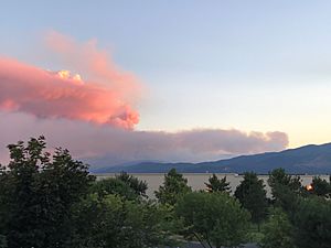
Lolo Peak Fire in 2017
In 2017, a large wildfire called the Lolo Peak Fire happened. It burned thousands of acres of land. This fire was about 10 miles (16 km) southwest of Lolo. Because of the fire, people had to leave their homes. Also, U.S. Route 12 was closed for a time.
Geography of Lolo, Montana
Lolo is located in the southern part of Missoula County. It sits where Lolo Creek meets the Bitterroot River. The Bitterroot River flows north into the Clark Fork. To the west of Lolo are the Bitterroot Mountains.
Lolo is at the eastern end of the Lolo Trail. Today, this trail is part of U.S. Route 12. This road crosses Lolo Pass at the Idaho state line. The pass is about 33 miles (53 km) west of Lolo. U.S. Route 93 also goes through the community.
Missoula is about 10 miles (16 km) northeast of Lolo, connected by US 12. Hamilton is about 37 miles (60 km) south via US 93.
Land and Water in Lolo
The Lolo area covers about 9.63 square miles (24.9 km2). Most of this area, about 9.46 square miles (24.5 km2), is land. The rest, about 0.17 square miles (0.44 km2), is water.
Lolo's Climate and Weather
Lolo has a climate with big changes in temperature throughout the year. Summers are warm to hot, and sometimes humid. Winters are cold, and can be very cold. This type of weather is called a humid continental climate.
| Climate data for Lolo, Montana | |||||||||||||
|---|---|---|---|---|---|---|---|---|---|---|---|---|---|
| Month | Jan | Feb | Mar | Apr | May | Jun | Jul | Aug | Sep | Oct | Nov | Dec | Year |
| Mean daily maximum °C (°F) | 0 (32) |
4 (39) |
9 (48) |
16 (60) |
21 (69) |
26 (78) |
30 (86) |
29 (85) |
23 (73) |
17 (62) |
7 (44) |
2 (35) |
15 (59) |
| Mean daily minimum °C (°F) | −14 (6) |
−12 (11) |
−6 (21) |
−1 (31) |
5 (41) |
9 (49) |
12 (53) |
11 (51) |
5 (41) |
−1 (30) |
−8 (18) |
−13 (9) |
−1 (30) |
| Average precipitation mm (inches) | 15 (0.6) |
10 (0.4) |
20 (0.8) |
28 (1.1) |
53 (2.1) |
58 (2.3) |
36 (1.4) |
38 (1.5) |
30 (1.2) |
18 (0.7) |
13 (0.5) |
13 (0.5) |
330 (13.1) |
| Source: Weatherbase | |||||||||||||
Population and People in Lolo
| Historical population | |||
|---|---|---|---|
| Census | Pop. | %± | |
| 1980 | 2,418 | — | |
| 1990 | 2,746 | 13.6% | |
| 2000 | 3,388 | 23.4% | |
| 2010 | 3,892 | 14.9% | |
| 2020 | 4,399 | 13.0% | |
| U.S. Decennial Census | |||
In 2010, there were 3,892 people living in Lolo. There were 1,218 households, which are groups of people living together. About 44% of these households had children under 18 living with them.
The average age of people in Lolo was 32 years old. About 31.3% of the population was under 18.
Education in Lolo
Most of Lolo is part of the Lolo Elementary School District. A small part is in the Missoula Elementary School District. Another small part is in the Woodman Elementary School District. All of Lolo is in the Missoula High School District.
The Lolo School District has two schools. These are Lolo Elementary for grades K-4 and Lolo Middle School for grades 5-8. In the 2021-2022 school year, 538 students were enrolled in these schools.
Students from Lolo attend high school in Missoula. The Missoula Public Library also has a branch located in Lolo.
Media and Infrastructure in Lolo
The FM radio station KDXT is licensed in Lolo. It plays country music.
Lolo is located where two main roads meet: U.S. Route 12 and U.S. Route 93. Healthcare services are provided in nearby Missoula.
Notable People from Lolo
- William M. Allen: An important person in the aerospace industry. He was born in Lolo.
- James Lee Burke: A mystery writer who has a home in Lolo.
- David James Duncan: A writer and fisherman.
See also
 In Spanish: Lolo (Montana) para niños


