
Long Branch (Chestatee River tributary) facts for kids
Long Branch is a small stream, also called a creek, located in the state of Georgia. It flows into a larger river called the Chestatee River. Long Branch is about 4.88 miles (7.85 kilometers) long.
Where Does Long Branch Start and Go?
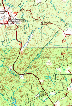
Long Branch starts in the southeastern part of Lumpkin County. This is just south of where State Route 52 and State Route 115 meet, east of the town of Dahlonega.
The creek flows southwest in a very straight line. It runs right next to State Route 115, which is also known as Long Branch Road. This road follows the creek from where it crosses the Chestatee River all the way to U.S. Route 19.
As Long Branch flows, it picks up water from two smaller, unnamed streams that join it from the east. Finally, it meets the Chestatee River. This meeting point is near the intersection of U.S. Route 19, State Route 60, and State Route 115, south of Dahlonega.
Understanding the Long Branch Watershed
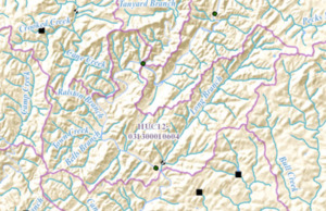
A watershed is an area of land where all the water drains into a common point, like a river or a lake. The area around Long Branch and its connected waters is called the Long Branch-Chestatee River sub-watershed. The United States Geological Survey (USGS) gives it a special code: HUC 031300010604.
This sub-watershed covers about 15 square miles. It is located southeast and south of Dahlonega. The shape of this watershed is quite unusual, looking like the capital letter "U". Long Branch forms the right side of this "U". The Chestatee River forms the left side, especially the part south of where it joins Yahoola Creek.
The Chestatee River in this area also receives water from several other creeks. These include Cane Creek, Ralston Branch, and Bells Branch. There's also a stream called Town Creek, but it's not the same as the much longer Town Creek that also flows into the Chestatee River. The Chestatee also gets water from six other unnamed streams before it leaves this sub-watershed and meets Long Creek.
