Louisburg, Minnesota facts for kids
Quick facts for kids
Louisburg
|
|
|---|---|

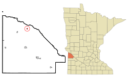
Location of Louisburg, Minnesota
|
|
| Country | United States |
| State | Minnesota |
| County | Lac qui Parle |
| Area | |
| • Total | 0.25 sq mi (0.66 km2) |
| • Land | 0.25 sq mi (0.66 km2) |
| • Water | 0.00 sq mi (0.00 km2) |
| Elevation | 1,040 ft (320 m) |
| Population
(2020)
|
|
| • Total | 31 |
| • Density | 122.05/sq mi (47.11/km2) |
| Time zone | UTC-6 (Central (CST)) |
| • Summer (DST) | UTC-5 (CDT) |
| ZIP code |
56256
|
| Area code(s) | 320 |
| FIPS code | 27-38258 |
| GNIS feature ID | 2395769 |
Louisburg is a small community called a hamlet in Lac qui Parle County, Minnesota, in the United States. In 2010, 47 people lived there. By 2020, the population was 31.
Contents
History of Louisburg
Louisburg was officially planned and marked out in 1887. This process is called "platting." A post office opened in Louisburg in 1888. It served the community for many years. However, the post office closed its doors in 1992.
Geography of Louisburg
Louisburg is a very small place. The United States Census Bureau is a government agency that collects information about people and places. According to them, Louisburg covers a total area of about 0.30 square miles (0.78 square kilometers). All of this area is land, meaning there are no lakes or large rivers within its boundaries.
Population and People
Louisburg has seen its population change over the years. Here is a look at how many people have lived there during different census counts:
| Historical population | |||
|---|---|---|---|
| Census | Pop. | %± | |
| 1910 | 88 | — | |
| 1920 | 99 | 12.5% | |
| 1930 | 77 | −22.2% | |
| 1940 | 94 | 22.1% | |
| 1950 | 93 | −1.1% | |
| 1960 | 91 | −2.2% | |
| 1970 | 75 | −17.6% | |
| 1980 | 52 | −30.7% | |
| 1990 | 42 | −19.2% | |
| 2000 | 26 | −38.1% | |
| 2010 | 47 | 80.8% | |
| 2020 | 31 | −34.0% | |
| U.S. Decennial Census | |||
Louisburg in 2010
The census in 2010 counted 47 people living in Louisburg. These people lived in 18 different homes, and 16 of these homes were families. The population density was about 156.7 people per square mile (60.5 people per square kilometer). This means that for every square mile, there were about 157 people.
There were 30 housing units in Louisburg. A housing unit is a house, apartment, or other place where people live. The average number of housing units was 100.0 per square mile (38.6 per square kilometer).
Most people in Louisburg were White, making up 93.6% of the population. A small number, 4.3%, were Asian. About 2.1% were from other races. People who identified as Hispanic or Latino made up 2.1% of the population.
Out of the 18 homes, about 33.3% had children under 18 living there. Most homes, 72.2%, were married couples living together. About 16.7% had a female head of the household with no husband present. Only 11.1% of homes were not families.
About 11.1% of all homes had only one person living in them. And 11.2% of these single-person homes had someone 65 years old or older living alone. The average number of people in each home was 2.61. For families, the average number of people was 2.81.
The average age of people in Louisburg was 46.3 years old. About 27.7% of residents were under 18 years old. About 8.4% were between 18 and 24 years old. People aged 25 to 44 made up 12.8% of the population. The largest group, 34.1%, was between 45 and 64 years old. Finally, 17% of the residents were 65 years old or older.
When looking at gender, 46.8% of the population was male. The remaining 53.2% of the population was female.
See also
 In Spanish: Louisburg (Minnesota) para niños
 | Jewel Prestage |
 | Ella Baker |
 | Fannie Lou Hamer |

