
Lover's Leap (Tahoe, California) facts for kids
Quick facts for kids Lover's Leap |
|
|---|---|

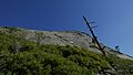
Lover's Leap seen from the Pony Express Trail.
|
|
| Highest point | |
| Elevation | 6,944 ft (2,117 m) NAVD 88 |
| Geography | |

Lover's Leap
Location in California
|
|
| Location | El Dorado County, California, United States |
| Parent range | Sierra Nevada |
| Topo map | USGS Pyramid Peak |
| Climbing | |
| Easiest route | Hike |
| Climbing type | traditional crag |
| Height | Up to 600 feet (180 m) |
| Pitches | 4 |
| Ratings | 5.5 to 5.12d, VB to V6 |
| Grades | I and II |
| Rock type | granite |
| Quantity of rock | weeks worth |
| Development | well developed |
| Cliff aspect | north |
| Season | spring to fall |
| Ownership | Eldorado National Forest |
| Camping | Lovers Leap Campground |
| Classic climbs |
|
| Stars | |

Lover's Leap is a tall, steep granite cliff in El Dorado County, California, United States. It's a famous landmark that many people notice when they travel by. It's also a very popular spot for rock climbers.
No one knows exactly how Lover's Leap got its name. But like many places called "Lover's Leap," there's a local story. One legend says that two Native American lovers jumped from the top of the cliff.
Contents
Exploring Lover's Leap: Geography
The cliffs of Lover's Leap stretch for over a third of a mile (0.6 km). They are very tall, ranging from 250 to 600 feet (76–183 m) high. The cliffs face towards the northwest.
You can find Lover's Leap just south of Route 50. It's located between Lake Tahoe and Sacramento. The old Pony Express trail, which was used for mail delivery long ago, runs right below the cliffs.
The closest big town area is Lake Tahoe, about 10 miles northeast. Lover's Leap is part of the Eldorado National Forest. The Forest Service has a campground nearby called Lover's Leap Campground. The historic Strawberry Lodge is also close by.
Climbing at Lover's Leap
Lover's Leap is a very popular place for climbing. It has more than 150 different climbing routes! It's most famous for its traditional multi-pitch routes. These routes often use natural cracks in the granite for climbers to hold onto. There are also some smaller climbing challenges called boulder problems.
Early Climbing History
The first recorded climb at Lover's Leap happened around 1950. A climber named Bruce Cooke climbed a chimney-like crack in the middle of the cliff.
In the next ten years, more routes were created by local climbers. Many of these climbers were part of the Sierra Club. They came from the Sacramento Valley and the Bay Area. Some of the routes they set up became very famous, like Corrugation Corner and Bear's Reach.
Bear's Reach became even more famous later. A climber named Dan Osman was filmed climbing it very quickly. This video became popular online.
Lover's Leap Becomes Popular
The 'Leap became a really popular climbing spot in the 1960s and 1970s. During this time, most of the important new climbing paths were discovered. For example, Traveler Buttress was set up in 1966. This route was even featured in a famous climbing book called Fifty Classic Climbs of North America.
A well-known climber named Royal Robbins moved to the area from Yosemite in the 1970s. He even opened the first climbing school at Lover's Leap!
Popular Climbing Routes Today
Here are some of the popular climbing routes you can find at Lover's Leap:
| Route name | Difficulty |
|---|---|
| Knapsack Crack | 5.5 |
| Deception | 5.6 |
| Harvey's Wallbangers, Center | 5.6 |
| Pop Bottle | 5.7 |
| Surrealistic Pillar | 5.7 |
| East Wall | 5.7 |
| Corrugation Corner | 5.7 |
| Bear's Reach | 5.7 |
| Haystack | 5.8 |
| East Crack | 5.8 |
| The Line | 5.9 |
| Traveler Buttress | 5.9 |
| Scimitar | 5.9R |
| Eagle's Buttress, Right | 5.10a |
Images for kids
-
Hogsback climbing area located at Lovers Leap.

