Strawberry, El Dorado County, California facts for kids
Quick facts for kids
Strawberry
|
|
|---|---|

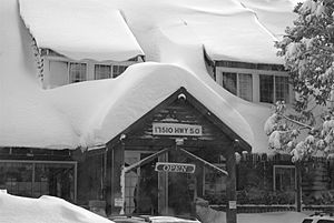
Strawberry Lodge after a winter storm, facing U.S. Route 50
|
|
| Country | United States |
| State | California |
| County | El Dorado County |
| Elevation | 5,738 ft (1,749 m) |
| ZIP code |
95735 (Twin Bridges, CA)
|
| Area code(s) | 530 |
| FIPS code | 32-60600 |
| GNIS feature ID | 0861100 |
| Reference #: | 707 |
Strawberry is a small community located in California. It's not officially a city or town, but a place where people live. You can find it along U.S. Route 50 in the beautiful Sierra Nevada mountains.
This community is nestled by the South Fork of the American River. If you drive by, you'll see a sign that says "population 50," meaning about 50 people live there.
A Look at Strawberry's Past
Strawberry has a cool history! It became a popular spot way back in the 1850s.
The Pony Express Connection
Strawberry was an important stop for the Pony Express. This was a famous mail service that used horseback riders to deliver letters super fast across the country. Strawberry was a station between Yank's Station and Webster's, Sugar Loaf House Station.
Along the Lincoln Highway
Later, by 1916, Strawberry was also on the Lincoln Highway. This was one of the first roads that went all the way across the United States. Today, Strawberry is recognized as California Historical Landmark #707 because of its historical importance.
Exploring Lovers Leap
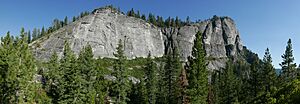
Strawberry is also known for a famous climbing spot called Lovers Leap. It's a huge rock formation that climbers love to challenge.
 | DeHart Hubbard |
 | Wilma Rudolph |
 | Jesse Owens |
 | Jackie Joyner-Kersee |
 | Major Taylor |


