Lowmead, Queensland facts for kids
Quick facts for kids LowmeadQueensland |
|||||||||||||||
|---|---|---|---|---|---|---|---|---|---|---|---|---|---|---|---|

Lowmead State School, 2023
|
|||||||||||||||
| Population | 179 (2021 census) | ||||||||||||||
| • Density | 0.5372/km2 (1.391/sq mi) | ||||||||||||||
| Postcode(s) | 4676 | ||||||||||||||
| Area | 333.2 km2 (128.6 sq mi) | ||||||||||||||
| Time zone | AEST (UTC+10:00) | ||||||||||||||
| Location |
|
||||||||||||||
| LGA(s) | Gladstone Region | ||||||||||||||
| State electorate(s) | Burnett | ||||||||||||||
| Federal Division(s) | Flynn | ||||||||||||||
|
|||||||||||||||
Lowmead is a small country town and area in the Gladstone Region of Queensland, Australia. It's a quiet place where people live and work. In 2021, a count of all people (called a Census) showed that 179 people lived in Lowmead.
Contents
Exploring Lowmead's Location
Lowmead is located in the northern part of its area. The North Coast railway line runs through the north-east of the area. This railway line helps connect Lowmead to other places.
- The Irkanda railway station is one stop on this line.
- The Baffle railway station is another stop nearby.
The Bruce Highway, a major road, also goes through the south-west of Lowmead. This highway is important for travel and transport across Queensland.
A Look Back at Lowmead's History
In 1887, a large piece of land, about 14,350 acres, was made available from a big farm called the Toweran pastoral run. This land was offered for people to choose and set up their own small farms. This happened on April 17, 1887.
The Lowmead Provisional School first opened its doors on May 20, 1908. A "provisional" school is one that is set up temporarily. It became a full State School in 1911. However, because not many students were attending, the school closed on December 12, 1975. Luckily, it reopened a few years later on January 23, 1978. In 2013, the school experienced flooding in January and March, which meant students missed several weeks of classes at the start of the year.
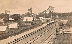
The Lowmead railway station used to serve the town, but it is now closed. It was located near where Lowmead Road and John Clifford Way meet.
Learning in Lowmead
Lowmead State School is a government primary school for students from Prep (the first year of school) to Year 6. It's located at 3077-3083 Lowmead Road. In 2017, the school had 14 students. It had 2 teachers and 4 other staff members who help run the school.
There are no high schools directly in Lowmead. Students who want to go to secondary school (Years 7-12) usually attend Rosedale State School, which is in the nearby town of Rosedale to the east.
Famous People from Lowmead
Lowmead has been home to some notable people:
- Trevor Coomber was a politician. A politician is someone who works in government, making decisions and laws for the community.
- Daniel Keighran is a soldier. A soldier is a person who serves in the army to protect their country.
 | James Van Der Zee |
 | Alma Thomas |
 | Ellis Wilson |
 | Margaret Taylor-Burroughs |


