Luahna Peak facts for kids
Quick facts for kids Luahna Peak |
|
|---|---|

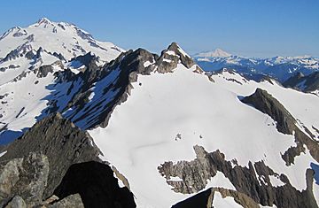
Luahna Peak seen from Clark Mountain
(Glacier Peak in upper left corner) |
|
| Highest point | |
| Elevation | 8,400 ft (2,600 m) |
| Prominence | 720 ft (220 m) |
| Geography | |
| Location | Chelan County, Washington, U.S. |
| Parent range | Cascade Range |
| Topo map | USGS Clark Mountain |
| Climbing | |
| First ascent | 1911 by Rodney Glisan, H.H. Prouty, Winthrop Stone, C.W. Whittlesey (Mazamas) |
| Easiest route | Scrambling and glacier travel |
Luahna Peak is a tall mountain in the North Cascades of Washington state. It stands about 8,400 feet (2,560 meters) high. This mountain is special because it has two main tops, or "summits." The highest point is the true summit, and there's another slightly lower one nearby.
You can find Luahna Peak in Chelan County, Washington, inside the Glacier Peak Wilderness. It's part of the Wenatchee National Forest. Luahna Peak is the second tallest mountain in its area, called the Dakobed Range. It's not far from Clark Mountain and Glacier Peak. Several large ice fields, called glaciers, are found on its slopes. These include the Richardson, Pilz, and Butterfly Glaciers. Water from the peak flows into the White River and Napeequa River. These rivers eventually join the Wenatchee River.
How Luahna Peak Was Formed
The North Cascades mountains are known for their rugged look. They have sharp peaks, tall spires, and deep valleys carved by ice. The amazing shapes of these mountains were created over millions of years by powerful natural events.
The story of the Cascade Mountains began a very long time ago. This was during a period called the late Eocene Epoch. At that time, a huge piece of Earth's crust, the North American Plate, was slowly moving over another piece, the Pacific Plate. This movement caused many volcanic eruptions.
Also, smaller pieces of land, called terranes, crashed into North America. These collisions helped build the North Cascades about 50 million years ago.
Later, during the Pleistocene period, which started over two million years ago, huge sheets of ice called glaciers covered the land. These glaciers moved slowly, scraping and shaping the mountains. They carved out the wide, "U"-shaped valleys we see today. The land was also pushed up and cracked by forces deep inside the Earth. These processes, along with the glaciers, created the tall peaks and deep valleys of the North Cascades.
Mountain Weather
Luahna Peak is in a place with a "marine west coast" climate. This means it gets a lot of moisture from the Pacific Ocean. Most weather systems start over the ocean and move towards the Cascade Mountains.
When these weather systems hit the tall peaks of the Cascades, they are forced to rise. As the air goes higher, it cools down and drops its moisture. This process is called Orographic lift. It causes a lot of rain or snow to fall on the mountains.
Because of this, Luahna Peak gets a lot of precipitation. Especially in winter, heavy snowfall feeds its glaciers. Winter days are often cloudy. But in summer, high pressure systems over the Pacific Ocean bring clear skies. This makes July through September the best time to visit Luahna Peak for climbing.
 | Kyle Baker |
 | Joseph Yoakum |
 | Laura Wheeler Waring |
 | Henry Ossawa Tanner |


