Luling, Texas facts for kids
Quick facts for kids
Luling, Texas
|
|
|---|---|

Oil Patch Museum
|
|
| Country | |
| State | |
| Counties | Caldwell, Guadalupe |
| Incorporated | 1874 |
| Government | |
| • Type | Council-Manager |
| Area | |
| • Total | 5.55 sq mi (14.38 km2) |
| • Land | 5.51 sq mi (14.27 km2) |
| • Water | 0.04 sq mi (0.11 km2) |
| Elevation | 410 ft (120 m) |
| Population
(2020)
|
|
| • Total | 5,599 |
| • Density | 1,065.15/sq mi (411.22/km2) |
| Time zone | UTC-6 (Central (CST)) |
| • Summer (DST) | UTC-5 (CDT) |
| ZIP code |
78648
|
| Area code(s) | 830 |
| FIPS code | 48-45096 |
| GNIS feature ID | 2410896 |
Luling is a city in Texas, United States. It is located in Caldwell and Guadalupe counties, right next to the San Marcos River. In 2020, about 5,599 people lived there.
Contents
History of Luling
Luling was founded in 1874. It was named after Charles Luling, a banker from New York. He helped pay for the railroad and bought the land where the town was built. Before Luling, a small farming community called Atlanta was nearby. Its residents moved to the new town of Luling, and Atlanta slowly disappeared.
Luling started as a busy railroad town. It became a lively place for cattle drivers who used the Chisholm Trail. Cowboys often passed through, making Luling known as a very spirited town. After the big cattle drives ended in the late 1880s, Luling became much quieter. About 500 people lived there, and growing cotton became the main way people made money. The town slowly grew, and by 1925, about 1,500 people lived in Luling.
A very important event for Luling was the discovery of oil. Edgar B. Davis risked everything he owned to drill for oil near the town. On August 9, 1922, his Rafael Rios No. 1 well found oil deep underground. It produced 150 barrels of oil every day! This discovery opened up a huge oilfield, about 12 miles long and 2 miles wide.
Because of the oil, Luling's economy quickly changed. It moved from farming and railroads to oil production. The town's population grew fast, reaching over 5,000 people. By 1924, the Luling Oil Field was producing more than 15 million barrels of oil each year. Oil was a major part of Luling's economy for the next 60 years. As oil became more important in the 1930s and 1940s, the railroads that helped start the town became less important.
Geography of Luling
Luling is in the southern part of Caldwell County. It is about 47 miles south of Austin. The city limits stretch south along Texas State Highway 80. They cross the San Marcos River and go into Guadalupe County, reaching Interstate 10. From Luling, you can drive about 57 miles west to San Antonio or 141 miles east to Houston on I-10.
The United States Census Bureau says that Luling covers a total area of 5.50 square miles. Most of this area, 5.46 square miles, is land. A small part, 0.04 square miles, is water.
Climate
The weather in Luling has hot, humid summers. The winters are usually mild to cool. Luling has a humid subtropical climate. This means it gets a lot of rain and has warm temperatures for most of the year.
| Climate data for Luling, Texas (1991–2020 normals, extremes 1897–present) | |||||||||||||
|---|---|---|---|---|---|---|---|---|---|---|---|---|---|
| Month | Jan | Feb | Mar | Apr | May | Jun | Jul | Aug | Sep | Oct | Nov | Dec | Year |
| Record high °F (°C) | 89 (32) |
99 (37) |
100 (38) |
100 (38) |
105 (41) |
108 (42) |
110 (43) |
111 (44) |
110 (43) |
101 (38) |
92 (33) |
89 (32) |
111 (44) |
| Mean maximum °F (°C) | 79.7 (26.5) |
83.2 (28.4) |
87.1 (30.6) |
90.7 (32.6) |
94.4 (34.7) |
98.4 (36.9) |
101.0 (38.3) |
103.1 (39.5) |
99.2 (37.3) |
93.3 (34.1) |
86.4 (30.2) |
80.5 (26.9) |
104.3 (40.2) |
| Mean daily maximum °F (°C) | 63.9 (17.7) |
67.5 (19.7) |
74.2 (23.4) |
81.0 (27.2) |
87.5 (30.8) |
93.6 (34.2) |
96.8 (36.0) |
98.2 (36.8) |
91.8 (33.2) |
83.8 (28.8) |
73.1 (22.8) |
65.3 (18.5) |
81.4 (27.4) |
| Daily mean °F (°C) | 51.7 (10.9) |
55.4 (13.0) |
62.2 (16.8) |
68.8 (20.4) |
76.6 (24.8) |
82.8 (28.2) |
85.3 (29.6) |
85.7 (29.8) |
79.9 (26.6) |
70.9 (21.6) |
60.6 (15.9) |
53.1 (11.7) |
69.4 (20.8) |
| Mean daily minimum °F (°C) | 39.6 (4.2) |
43.2 (6.2) |
50.3 (10.2) |
56.5 (13.6) |
65.6 (18.7) |
72.1 (22.3) |
73.8 (23.2) |
73.3 (22.9) |
68.1 (20.1) |
58.0 (14.4) |
48.2 (9.0) |
40.9 (4.9) |
57.5 (14.2) |
| Mean minimum °F (°C) | 23.5 (−4.7) |
27.1 (−2.7) |
31.0 (−0.6) |
38.6 (3.7) |
49.0 (9.4) |
62.9 (17.2) |
67.8 (19.9) |
66.2 (19.0) |
53.6 (12.0) |
39.0 (3.9) |
29.4 (−1.4) |
24.7 (−4.1) |
20.9 (−6.2) |
| Record low °F (°C) | −3 (−19) |
4 (−16) |
17 (−8) |
26 (−3) |
39 (4) |
50 (10) |
57 (14) |
56 (13) |
41 (5) |
26 (−3) |
19 (−7) |
4 (−16) |
−3 (−19) |
| Average precipitation inches (mm) | 2.40 (61) |
2.16 (55) |
2.74 (70) |
2.94 (75) |
4.20 (107) |
3.55 (90) |
1.85 (47) |
2.60 (66) |
3.42 (87) |
4.20 (107) |
2.57 (65) |
2.76 (70) |
35.39 (899) |
| Average snowfall inches (cm) | 0.0 (0.0) |
0.0 (0.0) |
0.0 (0.0) |
0.0 (0.0) |
0.0 (0.0) |
0.0 (0.0) |
0.0 (0.0) |
0.0 (0.0) |
0.0 (0.0) |
0.0 (0.0) |
0.0 (0.0) |
0.0 (0.0) |
0.0 (0.0) |
| Average precipitation days (≥ 0.01 in) | 7.1 | 6.8 | 7.1 | 6.1 | 6.5 | 6.5 | 4.4 | 4.5 | 7.0 | 5.9 | 6.3 | 7.1 | 75.3 |
| Average snowy days (≥ 0.1 in) | 0.0 | 0.0 | 0.0 | 0.0 | 0.0 | 0.0 | 0.0 | 0.0 | 0.0 | 0.0 | 0.0 | 0.0 | 0.0 |
| Source: NOAA | |||||||||||||
Population of Luling
| Historical population | |||
|---|---|---|---|
| Census | Pop. | %± | |
| 1880 | 1,114 | — | |
| 1890 | 1,792 | 60.9% | |
| 1900 | 1,349 | −24.7% | |
| 1910 | 1,404 | 4.1% | |
| 1920 | 1,502 | 7.0% | |
| 1930 | 5,970 | 297.5% | |
| 1940 | 4,437 | −25.7% | |
| 1950 | 4,297 | −3.2% | |
| 1960 | 4,412 | 2.7% | |
| 1970 | 4,719 | 7.0% | |
| 1980 | 5,039 | 6.8% | |
| 1990 | 4,661 | −7.5% | |
| 2000 | 5,080 | 9.0% | |
| 2010 | 5,411 | 6.5% | |
| 2020 | 5,599 | 3.5% | |
| U.S. Decennial Census 2010-2020 |
|||
Luling has grown quite a bit over the years. In 2020, the city had 5,599 people living there. There were 2,070 households and 1,570 families.
The city is home to people from many different backgrounds. In 2020, about 36% of the people were White (not Hispanic). About 6% were Black or African American. Over half of the population, about 53%, were Hispanic or Latino.
| Race | Number | Percentage |
|---|---|---|
| White (NH) | 2,031 | 36.27% |
| Black or African American (NH) | 359 | 6.41% |
| Native American or Alaska Native (NH) | 5 | 0.09% |
| Asian (NH) | 32 | 0.57% |
| Pacific Islander (NH) | 1 | 0.02% |
| Some Other Race (NH) | 39 | 0.7% |
| Mixed/Multi-Racial (NH) | 140 | 2.5% |
| Hispanic or Latino | 2,992 | 53.44% |
| Total | 5,599 |
Culture and Fun in Luling
Luling is famous for its annual Watermelon Thump. This big festival happens every year during the last full weekend in June. It's a huge celebration for local people and brings many visitors to town. A popular and fun event at the Thump is the watermelon seed spitting contest!
Another fun event is Night in Old Luling, which takes place in October. It has games, food, booths, and even a scarecrow contest.
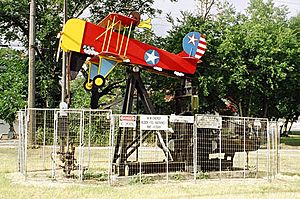
You'll notice something unique about Luling's oil jacks. Many of them along the main streets are decorated with fun, whimsical characters. For example, you might see one shaped like a girl eating a watermelon!
Luling was also home to the very first Buc-ee's travel center. In 2024, Buc-ee's replaced its original Luling location with a brand new, even bigger store. This new building is now known as the world's largest convenience store!
Education in Luling
Students in Luling attend schools that are part of the Luling Independent School District. The district has several schools for different age groups, from young children to high school students.
| School name | Grades taught | Students enrolled |
|---|---|---|
| Rosenwald Primary | Head start | 190 |
| Luling Primary | Pre-K-K–1 | 231 |
| Leonard Shanklin Elementary | 2–5 | 310 |
| Gilbert Gerdes Junior High | 6–8 | 302 |
| Luling High School | 9–12 | 432 |
Famous People from Luling
Many notable people have connections to Luling, including:
- Emory Bellard, a college football coach
- Bo Burris, an NFL football player
- Jennie Everton Clarke, who founded the Belle Haven Orphan home
- Michael Dorn, an actor
- Tamron Hall, a journalist and television talk show host
- Obert Logan, an NFL football player for the Dallas Cowboys and New Orleans Saints
- Craig Mager, an NFL football player for the Denver Broncos
- Marshall W. Mason, a Broadway director
- Riley Odoms, an NFL football player for the Denver Broncos
See also
 In Spanish: Luling (Texas) para niños
 | Bessie Coleman |
 | Spann Watson |
 | Jill E. Brown |
 | Sherman W. White |


