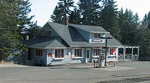
Lutsen, Minnesota facts for kids
Quick facts for kids
Lutsen
|
|
|---|---|
| Country | United States |
| State | Minnesota |
| County | Cook |
| Area | |
| • Total | 10.69 sq mi (28.69 km2) |
| • Land | 10.58 sq mi (28.39 km2) |
| • Water | 0.12 sq mi (0.30 km2) |
| Elevation | 669 ft (204 m) |
| Population
(2020)
|
|
| • Total | 220 |
| • Density | 20.80/sq mi (8.03/km2) |
| Time zone | UTC-6 (CST) |
| • Summer (DST) | UTC-5 (CDT) |
| ZIP codes |
55604, 55612
|
| Area code(s) | 218 |
| GNIS feature ID | 657265 |
Lutsen (pronounced LOOT-sən) is a small community in Minnesota, United States. It's a special type of place called a census-designated place (CDP). This means it's an area that the government counts for population, but it doesn't have its own city government. Lutsen is located in Cook County. In 2020, about 220 people lived here.
Lutsen is known for its beautiful natural surroundings. It sits within the huge Superior National Forest. It is also right on the North Shore of Lake Superior, which is a very scenic area.
Contents
Exploring Lutsen's Location
Lutsen is found in a lovely part of Minnesota. It is about 18 miles southwest of the city of Grand Marais. It is also 65 miles northeast of the city of Two Harbors.
Nearby Natural Attractions
There are many cool places to explore near Lutsen.
- Cascade River State Park is very close by.
- The famous Superior Hiking Trail also runs through the area. This trail is great for long walks and enjoying nature.
Main Road Through Lutsen
The main road that goes through Lutsen is Minnesota State Highway 61. This highway follows the edge of Lake Superior. It connects cities like Duluth to Grand Portage, which is near the Canadian border.
What Drives Lutsen's Economy?
The main way people in Lutsen make a living is through tourism. Many visitors come to enjoy the area's natural beauty and activities.
Lutsen Mountains Ski Resort
The biggest business in Lutsen is the Lutsen Mountains Ski Resort. This resort is a popular spot for skiing and snowboarding in the winter. It attracts many people from all over.
Other Resorts and Lodging
Besides the ski resort, Lutsen also has several other resorts. These places offer lodging and activities for tourists. They help make Lutsen a great place for vacations.
Understanding Lutsen's Climate
Lutsen has a climate with cold winters and mild summers. This is typical for places near Lake Superior.
| Climate data for Lutsen, Minnesota, 1991–2020 normals: 1300ft (396m) | |||||||||||||
|---|---|---|---|---|---|---|---|---|---|---|---|---|---|
| Month | Jan | Feb | Mar | Apr | May | Jun | Jul | Aug | Sep | Oct | Nov | Dec | Year |
| Mean daily maximum °F (°C) | 17.0 (−8.3) |
21.2 (−6.0) |
32.6 (0.3) |
44.3 (6.8) |
58.4 (14.7) |
66.3 (19.1) |
72.9 (22.7) |
70.8 (21.6) |
62.3 (16.8) |
49.0 (9.4) |
34.4 (1.3) |
22.3 (−5.4) |
46.0 (7.8) |
| Daily mean °F (°C) | 6.9 (−13.9) |
10.3 (−12.1) |
21.8 (−5.7) |
34.4 (1.3) |
48.2 (9.0) |
57.4 (14.1) |
63.5 (17.5) |
61.6 (16.4) |
53.4 (11.9) |
40.8 (4.9) |
27.1 (−2.7) |
14.8 (−9.6) |
36.7 (2.6) |
| Mean daily minimum °F (°C) | −3.2 (−19.6) |
−0.6 (−18.1) |
11.0 (−11.7) |
24.4 (−4.2) |
38.1 (3.4) |
48.5 (9.2) |
54.1 (12.3) |
52.3 (11.3) |
44.4 (6.9) |
32.6 (0.3) |
19.9 (−6.7) |
7.4 (−13.7) |
27.4 (−2.6) |
| Average precipitation inches (mm) | 1.39 (35) |
0.87 (22) |
1.55 (39) |
3.06 (78) |
3.27 (83) |
3.77 (96) |
3.61 (92) |
3.77 (96) |
3.89 (99) |
3.88 (99) |
2.62 (67) |
1.89 (48) |
33.57 (854) |
| Average snowfall inches (cm) | 27.1 (69) |
13.7 (35) |
9.2 (23) |
3.8 (9.7) |
0.4 (1.0) |
0.0 (0.0) |
0.0 (0.0) |
0.0 (0.0) |
trace | 1.8 (4.6) |
14.2 (36) |
17.4 (44) |
87.6 (222.3) |
| Source 1: NOAA (1981-2010 precipitation) | |||||||||||||
| Source 2: XMACIS (1991-2005 snowfall) | |||||||||||||
Who Lives in Lutsen?
The population of Lutsen is quite small. It has seen a slight increase in recent years.
Population Changes Over Time
| Historical population | |||
|---|---|---|---|
| Census | Pop. | %± | |
| 2010 | 190 | — | |
| 2020 | 220 | 15.8% | |
| U.S. Decennial Census 2020 Census |
|||
In 2010, there were 190 people living in Lutsen. By the year 2020, the population had grown to 220 people. This shows a small but steady growth in the community.
Learning in Lutsen
All the schools in Cook County, where Lutsen is located, are part of one school district.
Cook County School District
The entire county is served by Cook County ISD 166. This means that students in Lutsen attend schools within this district.
See also
 In Spanish: Lutsen (Minnesota) para niños
 | Jackie Robinson |
 | Jack Johnson |
 | Althea Gibson |
 | Arthur Ashe |
 | Muhammad Ali |


