Mātukituki River facts for kids
Quick facts for kids Mātukituki River |
|
|---|---|

Mātukituki River West Branch
|
|
| Country | New Zealand |
| Physical characteristics | |
| Main source | Mount Aspiring National Park |
| River mouth | Lake Wānaka 300 m (980 ft) |
| Length | 50 km (31 mi) |
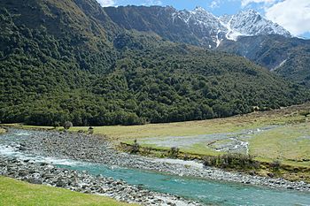
The Mātukituki River is a cool river in the Southern Alps of New Zealand. These mountains are on the South Island.
The river has two main parts: the West Branch and the East Branch. Both start high up in the mountains near Mount Aspiring. Their water comes mostly from melting glaciers. Each branch flows for about 20 kilometers. Then, they meet near a place called Camerons Flat.
After joining, the Mātukituki River leaves Mount Aspiring National Park. It flows for another 30 kilometers. Finally, it empties into Lake Wānaka at its southwestern edge.
Six glaciers feed streams into the Mātukituki River. The biggest ones are the Upper Volta Glacier, Rob Roy Glacier, Maud Francis Glacier, and Avalanche Glacier.
From Camerons Flat, the river spreads out into many small channels. This is called a "braided" river. It then goes through a narrow gorge. It flows under the West Wanaka bridge before reaching Lake Wanaka.
Contents
How the Mātukituki Valley Was Formed
The Southern Alps started forming over 220 million years ago. Back then, they were just sediment and rock on the seafloor. Over time, intense heat and pressure turned these into hard rock. Then, the land slowly pushed upwards to create the mountains we see today.
Later, during the ice ages, huge glaciers moved through the valleys. They carved out the landscape, making the valleys wider and deeper. This is how the Mātukituki Valley got its shape.
History of People in the Valley
The area around Mount Aspiring has a long history with the Māori. They called Mount Aspiring Tititea. Māori tribes traveled here from far away. They came to collect birds like kakapo, kereru, kaka, and tui from the forests. For the first 200 years of Māori settlement, Moa birds also lived along the forest edges.
The old Māori iwi (tribes) of Kāti Māmoe and Ngāi Tahu had settlements around Lake Wanaka and Lake Hāwea. One settlement was called Nehenehe. It was on the northern side of where the Mātukituki River flows into Lake Wanaka. People have found old ovens near the lake shore. These were used to cook tī kōuka (cabbage tree) roots.
The first European to see Mount Aspiring was John Turnbull Thompson in 1857. He was a government surveyor. James Hector explored the West Mātukituki Valley in 1862. Farming started in the valley in the 1870s.
Animals and Plants of the Mātukituki Valley
Today, beech trees are the main type of forest in the Mātukituki Valley. Red beech trees like warmer spots in the valley. You can find them near Aspiring Hut. Silver beech trees grow more towards the wetter, western part of the valley. Mountain beech trees are common in the drier, eastern part.
Underneath these open forests, you can find many types of ferns and mosses. Above the tree line, which is about 1100 meters high, the plants change. You'll see short, sub-alpine shrubs. Higher up, there are alpine tussock grasslands and rocky areas.
Many birds live in the beech forest. Insect-eating birds like fantail, tomtit, and rifleman are common. The seed-eating kakariki bird especially likes areas with red beech trees. On the river flats, you might see paradise shelducks. In summer, spur-winged plover and oystercatcher birds are often seen on farms and along the road from Wanaka.
Fun Things to Do in the Valley
The Mātukituki River valley is a great place for visitors! It has a ski resort called Treble Cone. You can also go on a thrilling ride with a jetboat operator called River Journeys.
There are many walking trails, also called tramping trails. These trails let you explore the area. A very popular walk leads to a viewpoint under the Rob Roy Glacier. To get there, you cross the Mātukituki River West Branch on a swing bridge.
The unsealed Wanaka Mount Aspiring Road follows the river for most of its path. It goes past where the East Branch and West Branch meet. It continues part-way along the West Branch to a Department of Conservation NZ car park at Raspberry Creek shelter.
See also
 In Spanish: Río Mātukituki para niños
 | Victor J. Glover |
 | Yvonne Cagle |
 | Jeanette Epps |
 | Bernard A. Harris Jr. |

