MacDonnell Shire facts for kids
Quick facts for kids MacDonnell Regional CouncilNorthern Territory |
|||||||||||||||
|---|---|---|---|---|---|---|---|---|---|---|---|---|---|---|---|
 |
|||||||||||||||
| Population | 6,029 (2016 census) | ||||||||||||||
| • Density | 0.0224306/km2 (0.058095/sq mi) | ||||||||||||||
| Established | 2008 | ||||||||||||||
| Area | 268,784.20 km2 (103,778.2 sq mi) | ||||||||||||||
| Mayor | Sid Anderson | ||||||||||||||
| Council seat | Alice Springs (not part of council) | ||||||||||||||
| Region | Alice Springs Region | ||||||||||||||
| Territory electorate(s) | Namatjira, Stuart | ||||||||||||||
| Federal Division(s) | Lingiari | ||||||||||||||
| Website | MacDonnell Regional Council | ||||||||||||||
|
|||||||||||||||
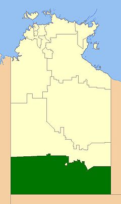
The MacDonnell Regional Council is a special kind of local government area in the Northern Territory, Australia. It was created on July 1, 2008. This council helps manage a very large area by bringing together many smaller community councils and places that didn't have their own local government before. The current President of the MacDonnell Regional Council is Sid Anderson.
Contents
About the MacDonnell Regional Council
This council is like a local government for a huge part of the Northern Territory in Australia. It started on July 1, 2008. Before that, many smaller local groups managed different communities. The MacDonnell Regional Council was formed by joining these smaller groups and other areas that didn't have their own local council. This helps to manage services and communities across a very large region.
Where is the MacDonnell Regional Council Located?
The MacDonnell Regional Council covers a massive area, over 268,784 square kilometres! This is a huge space, covering the southern part of the Northern Territory. It shares a border with South Australia. Two important towns, Alice Springs and Yulara, are located inside the council's area. However, they are not actually part of the council itself. Think of them like islands surrounded by the council's land.
In 2009, about 7,142 people lived in the MacDonnell Regional Council area.
How the Council is Organised
The MacDonnell Regional Council is divided into four main sections called "wards." These wards help to make sure that different parts of the large area are represented. There are 12 council members in total. These members are chosen in elections, and they work to make decisions for the communities in their wards.
Wards and Their Communities
Here are the four wards and some of the towns and communities that belong to each one:
- Rodinga Ward (has 4 council members)
- Amoonguna
- Aputula (also known as Finke)
- Santa Teresa (also known as Ltyentye Apurte)
- Titjikala (also known as Tapatjatjaka)
- Ljirapinta Ward (has 3 council members)
- Hermannsburg (also known as Ntaria)
- Wallace Rockhole (also known as Ulana)
- Luritja Pintubi Ward (has 3 council members)
- Haasts Bluff (also known as Ikuntji)
- Kintore (also known as Walungurru)
- Mount Liebig (also known as Watijawanu)
- Papunya (also known as Warumpi)
- Iyarrka Ward (has 2 council members)
- Kaltukatjara (also known as Docker River)
- Imanpa
- Areyonga (also known as Utju)
 | John T. Biggers |
 | Thomas Blackshear |
 | Mark Bradford |
 | Beverly Buchanan |

