Maiden Castle, Cheshire facts for kids
Quick facts for kids Maiden Castle |
|
|---|---|

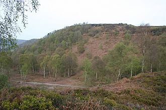
Maiden Castle surmounting Bickerton Hill
|
|
| General information | |
| Architectural style | Iron Age hill fort |
| Country | England |
| Coordinates | 53°04′17″N 2°45′00″W / 53.071418°N 2.749951°W |
| Construction started | 600 BC |
| Technical details | |
| Size | 1.66 acres (6,700 m2) interior 3 acres (12,000 m2) including defences |
Maiden Castle is an ancient hill fort from the Iron Age. It's like a very old, fortified village built on top of a hill. Many such forts were built across Britain during the Iron Age.
Maiden Castle is one of only seven hill forts found in Cheshire, a county in northern England. People likely lived here from around 600 BC. They stayed until the Roman conquest of Britain in the 1st century AD.
A tribe called the Cornovii lived in the area back then. However, we don't have much proof they lived at Maiden Castle itself. This is because they didn't leave behind special pottery or metal items.
Since Roman times, parts of the fort have been dug up for stone. It was also used for military training. Today, Maiden Castle is a Scheduled Ancient Monument. This means it's a very important historical site that is protected by law. The National Trust owns it, and you can visit it. However, too many visitors have caused parts of the site to wear away. Because of this, it is now considered "at high risk" from erosion.
Where is Maiden Castle Located?

There are over 1,300 hill forts in England. Most of them are in the southern part of the country. Only seven are found in Cheshire.
In Cheshire, there are two main groups of hill forts. Each group has three forts. Maiden Castle is a bit different because it's not in either of these groups. It sits about 9 miles (14 km) south-south-west of the closest group.
Maiden Castle is located on a central ridge that runs through Cheshire. All the hill forts in Cheshire are found along this ridge. It sits on a small promontory, which is a high point on a flat area called a plateau. This plateau is part of Bickerton Hill, which is about 694 ft (212 m) high.
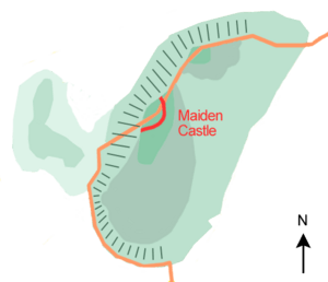
The land to the west and north of the fort slopes very steeply. This natural slope meant that people didn't need to build extra defenses there. It also gave them a great view of the Cheshire Plain. To the east, the plateau continues for about 1 mile (2 km) long and 0.5 miles (800 m) wide. Here, people built strong walls called ramparts because there were no natural defenses.
How Was Maiden Castle Built?
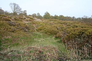
Maiden Castle didn't need artificial defenses on its north and west sides. This was because the hill's natural slope was very steep. But on the other sides, there are two large artificial banks. These banks are about 35 ft (11 m) apart.
Both banks are about 40 ft (12 m) wide. The ground they are on slopes downwards. This means the outside of each bank is taller than the inside. They are about 5 ft (1.5 m) high on the inside and 7 ft (2.1 m) high on the outside. There is no sign that a ditch was dug along with these banks to protect the fort.
The main way into the fort is on the east side. Here, the inner bank curves inwards towards the fort. The outer bank has a gap, but it doesn't curve in the same way. There might have been two other entrances where the banks met the steep cliffs to the north and south.
At these points, the outer bank turns inwards. This could mean there was an entrance that curved in, right next to the cliff edge. This is similar to the entrance at the Helsby hill fort in Cheshire. Or, it might have been an effort to make sure the banks met the cliff perfectly, leaving no gaps in the fort's defenses.
The History of Maiden Castle
Scientists used a method called radiocarbon dating to figure out when the fort's defenses were built. They found that the ramparts were constructed around 600 BC. These defenses were made from earth and wood.
The inner rampart was originally about 20 ft (6.1 m) wide. It had a strong wall of dry stone (stones fitted together without mortar) behind it, which was at least 10 ft (3.0 m) high. The outer bank was first about 25 ft (7.6 m) wide and 10 ft (3.0 m) high. It was made of sand and had a dry stone front, but no wall behind it.
Later, the outer bank was made even bigger. Its front was extended about 8 to 10 ft (2.4 to 3.0 m) away from the fort. Its height was probably increased to 12 ft (3.7 m). The defenses cover about 1.66 acres (6,700 m2) of the entire 3 acres (12,000 m2) Maiden Castle site.
An archaeologist named James Forde-Johnston studied hill forts in the 1960s. He said that Maiden Castle had unusually strong defenses for such a small site. Not many artefacts (old objects) have been found here. One item found was a piece of Iron Age pottery.
Maiden Castle was likely used until the Romans arrived in Britain in the 1st century AD. The outer bank might have been rebuilt around that time.
The name "Maiden Castle" is used for several places in Britain. For example, there's a famous one in Dorset. The name probably means a "fort that looks impossible to capture" or one that has never been defeated in battle.
Even though parts of the site were quarried in the 1600s and used for military exercises in the 1900s, Maiden Castle is still in good shape. Archaeologists excavated (dug up) the site between 1932 and 1935. This work was done by W. J. Varley, who also explored other hill forts in Cheshire. More digging happened in 1980 and 1981.
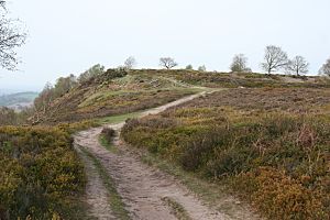
In 1995, Maiden Castle became a Scheduled Ancient Monument. This protects it from any changes without permission. The area around the fort is a mix of heathland, heather, and bracken plants.
The National Trust owns the site, and it's open to everyone. However, too many visitors have caused problems like erosion. Animal burrows have also damaged Maiden Castle. It's listed as "at high risk" because of erosion from visitors and the spread of bracken. Five of Cheshire's seven hill forts are considered "at high risk." This is a higher number compared to other protected sites in North West England.
 | Anna J. Cooper |
 | Mary McLeod Bethune |
 | Lillie Mae Bradford |


