
Bickerton Hill facts for kids
Quick facts for kids Bickerton Hill |
|
|---|---|

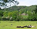
Northern Bickerton Hill, showing Raw Head and Musket's Hole crags
|
|
| Highest point | |
| Elevation | 227 m (745 ft) |
| Prominence | 148.5 m (487 ft) |
| Geography | |
| Location | Cheshire, England |
| Parent range | Mid Cheshire Ridge |
| OS grid | SJ508548 |
| Topo map | OS Explorer 257, Landranger 117 |
Bickerton Hill is made up of two low red sandstone hills. They are found at the southern end of the Mid Cheshire Ridge in Cheshire, north-west England. The highest point is called Raw Head, which is 227 metres tall. It is located on the northern hill. Part of the southern hill is also known as Larkton Hill.
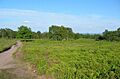
People have lived on these hills since the Neolithic or Bronze Age. An Iron Age hill fort called Maiden Castle is on the southern hill's top. It is a very important historical site, protected as a Scheduled monument. Copper mining and quarrying have taken place here since the 1600s. You can still see an old engine house chimney from the mining days. There are also several caves in the sandstone, and some were once homes. The Sandstone Trail, a long walking path, goes along the ridge. This makes the area popular with hikers.
A large part of the southern hill is a Site of Special Scientific Interest (SSSI). This means it is protected for its important plants and animals. Much of this hill belongs to the National Trust. The top of the hill has a large area of lowland heathland. This type of habitat is rare in Cheshire and is very important for reptiles. A special fern called lobed maidenhair spleenwort grows here. It is rare in Britain. Rare moths like the bleached pug and alder kitten have also been seen.
Contents
Exploring Bickerton Hill's Past
Ancient Settlements: Neolithic and Bronze Age
Signs near Rawhead Farm suggest people lived on the northern hill long ago. This was during the Neolithic or Bronze Age. They might have built a "banjo enclosure," which is a round area with a narrow entrance. Two flint tools from the Bronze Age have been found on the southern hill. A Bronze Age burial mound, called a bowl barrow, is also nearby.
Maiden Castle: An Iron Age Fort
.jpg)
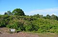
The remains of an Iron Age hill fort, Maiden Castle, are on the southern hill. It sits at 212 metres high. This fort was built around 600 BC. It is the most southerly of Cheshire's seven hill forts. You can still see its double earth walls. They form a semicircle that covers an area of about 1.3 acres. The fort had one entrance on the east side, with strong defensive banks.
Archaeologists found that both walls were made stronger with dry stone and timber. The fort was burned down around 400 BC. However, people likely lived in the area until the Romans arrived. Even with quarrying and military training over the years, the site is well preserved. It is now a Scheduled monument and owned by the National Trust. The Trust works to remove trees and plants that could damage the old earthworks.
Bickerton's Name and Early History
The name "Bickerton" comes from an old Anglo-Saxon word for bees. A settlement here was mentioned in the Domesday Book. It was described as "waste" or destroyed. This was likely due to William the Conqueror's actions in 1069–70. The area also had some woodland, probably on the hills.
Copper Mining and Quarrying

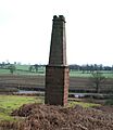
Copper mining started at Bickerton in 1696. The mine was owned by the Egerton family. Six mine shafts were used, and one was dug 156 feet deep. Mining continued off and on until 1906. You can still see an old red sandstone chimney from the mine. It stands by the A534 near Gallantry Bank. This chimney is from the early 1800s and is a protected building. The Copper Mine pub in nearby Broxton has old mining tools and pictures.
Quarrying also happened on the hills, including at Maiden Castle. Sandstone was dug out for building. Sand was also collected for cleaning. An iron tool for splitting rock from the 1600s was found at Maiden Castle.
Caves and Hermits

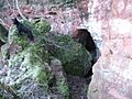
Mad Allen's Hole is a cave on the southern Bickerton Hill. Some believe it was where John Harris, "the English Hermit," lived for 46 years. He was said to be a rich man who became a hermit after his parents stopped him from marrying. He moved to this cave in the 1760s. However, recent studies question if this was truly his cave. The name "Mad Allen's Hole" only appeared in the late 1800s.
In the early 1800s, the Bloody Bones caves on the northern hill were home to outlaws. These people stole cheese from farms and robbed graves. They also sold sand for cleaning. Seven of them were caught and punished around 1834.

The Droppingstone Well is just north of the Raw Head summit. It has a plaque from 1861. An old photo from 1910 shows local people using the well.
Recent History: 20th and 21st Centuries
The area around Maiden Castle was used for military training in the 1900s. Soldiers dug many small trenches there. The heathland on the southern hill was not managed from the 1940s until 1983. That's when the National Trust bought 66 hectares of land. They bought another 51 hectares in 1991. Most of the southern hill and part of the northern hill became Sites of Special Scientific Interest in 1979.
The Sandstone Trail, a long walking path, opened in 1974. A race along the trail started three years later. In 2008, there was a plan to build a tall wind-monitoring mast near Bickerton Hill. Local people protested, and the plan was stopped.
Bickerton Hill's Nature and Landscape
Geography and Geology

The two Bickerton Hills are south-west of the Peckforton Hills. They are the southern end of the Mid Cheshire Ridge. This ridge runs north to south through Cheshire. The southern part of the ridge, including Bickerton Hills, is a special area. The two hills are separated by a valley where the A534 road runs.
The top of the northern hill, Raw Head, is 227 metres high. It is the highest point on the Mid Cheshire Ridge. Raw Head has a trig point for surveying. The southern hill has two high points: Maiden Castle (212 metres) and the Kitty Stone (193 metres). The southern high point is sometimes called Larkton Hill.
The hills are made of sandstone from the Sherwood Sandstone Group. This rock formed about 250 million years ago. You can see the sandstone in cliffs on the western side of the northern hill. There are also smaller areas on the southern hill. Several natural caves exist. Mad Allen's Hole on the southern hill has two levels. The Queen's Parlour is a large cave directly under the Raw Head trig point.
Plants and Animals

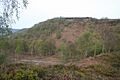
A large area of the southern hill (91 hectares) is a Site of Special Scientific Interest (SSSI). It includes birch woods and heathland. The National Trust owns and manages most of this area. The lowland heath habitat here is very valuable. It is rare in Cheshire. Heathland needs to be managed, for example, by grazing, to stop it from turning into scrub or woodland.
Plants of the Heathland
The heathland has lots of common heather and wavy hair grass. Bilberry is also common. You might see patches of bracken, bell heather, and cross leaved heath. The woods are mostly silver birch, with aspen, holly, rowan, and wild cherry. A very rare fern, Lobed Maidenhair Spleenwort, was found here in 1997. It grows on sandstone.
Animals of Bickerton Hill

Bickerton Hill is full of wildlife. Rare insects like the bleached pug and alder kitten moths live here. You might also see the green hairstreak butterfly and the common glow-worm. Common butterflies include the comma, gatekeeper, red admiral, and tortoiseshell.
Many birds live here, such as the pied flycatcher, jay, long-tailed tit, and nuthatch. Birds of prey like the buzzard, kestrel, and sparrowhawk are common. Rare sightings include the merlin and peregrine falcon.
The reptiles at Bickerton Hill are very important. It is one of the few places in Cheshire where the adder has been seen since 1995. Other reptiles include the slowworm and common lizard.

Managing the Land
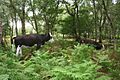
The National Trust manages the area to help the heathland grow. They clear birch trees, scrub, and bracken. They also use cattle to graze in the summer. Sometimes, clearing trees can cause disagreements with local groups. The woodland areas are managed to have trees of different ages. Dead wood is left because it provides an important habitat.
Walkers can cause footpath erosion. Also, dog waste is a problem if not disposed of properly. Bickerton Hill is part of the Cheshire Biodiversity Action Plan.
Raw Head: A Geological Wonder

A part of the northern Bickerton Hill (13.51 hectares) is a geological SSSI. Its exposed sandstones help scientists understand the Triassic period. This SSSI includes the western cliffs of the hill, from Droppingstone Well to Tower Wood. The land is managed for pheasant shooting and has conifer and mixed woodland.
The rocks here are from the Sherwood Sandstone Group, formed about 250 million years ago. The fine red sandstones show that they were laid down by sandy rivers. The pebble beds in the upper levels show larger particles from coarser rivers. In 2008, the site was in good condition. The rocks were well exposed, and there was little damage from trees or graffiti.
Visiting Bickerton Hill
Walking and Activities
Bickerton Hill is a popular place for walkers and dog walkers. The Sandstone Trail, a long-distance path, goes over both hills. There are also other public footpaths and marked paths. The National Trust counted 8,500 walkers on the Sandstone Trail in early 2006. They also estimate 8,000 dog walks happen here each year. The Sandstone Trail Race also goes over the hills.
Access and Parking
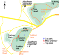
You can reach the northern hill by road. Coppermine Lane goes up from the A534. New Lane runs from Harthill to Droppingstone Farm. Several other lanes run around the southern hill. There are two free car parks open during the day. One is near Bickerton, and the other is near Duckington. There is also a small parking area for disabled visitors. You need permission in advance to use it. An easy-access path from this parking area leads to Maiden Castle. Most paths have wicket gates or kissing gates, but some have stiles.
You must stay on the marked paths. Cycling is not allowed, and horse riding needs a permit on National Trust land. Camping and overnight parking are not allowed. Information boards are in the car parks and along the Sandstone Trail.
Images for kids
-
Northern Bickerton Hill, showing Raw Head and Musket's Hole crags
-
Rampart of Maiden Castle
-
Copper mine chimney
-
Mad Allen's Hole
-

Droppingstone Well
-
Sketch map of the two Bickerton Hills
-
Southern Bickerton Hill from Cuckoo Rock. The southmost high point is in the foreground, with the northmost high point behind (left)
-
Heathland on the southern hill's summit plateau, here dominated by bilberry
-
Birch woods on the southern hill; grazing promotes heathland regeneration
-
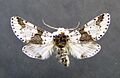
Alder kitten moth
-
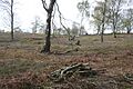
Tree felling promotes heathland regeneration but reduces the area's aesthetic value
-
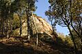
Exposed sandstone at Raw Head


