
Manganese, Minnesota facts for kids
Quick facts for kids
Manganese
|
|
|---|---|

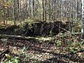
Ruins and crumbling concrete foundation of the old Fitger Hotel in Manganese, October 2016
|
|
| Etymology: Manganese | |

Manganese
Location in Minnesota

Manganese
Location in the United States
|
|
| Country | United States |
| State | Minnesota |
| County | Crow Wing |
| Founded | March 13, 1912 |
| Incorporated | November 10, 1913 |
| Dissolved | July 17, 1961 |
| Elevation | 1,250 ft (380 m) |
| Time zone | UTC−6 (Central (CST)) |
| • Summer (DST) | UTC−5 (CDT) |
| GNIS feature ID | 654881 |
Manganese is a ghost town in Minnesota, USA. It was once a busy mining community that existed between 1912 and 1960. The town was built in Crow Wing County on the Cuyuna Iron Range, about 2 miles (3.2 km) north of Trommald, Minnesota.
Manganese was named after the mineral found in large amounts nearby. It was a special place because its mines had a lot of manganese mixed with iron ore. This area is still the biggest source of manganese in the United States. Many people who lived in Manganese were immigrants who came from Europe before World War I, looking for a new life.
At its busiest around 1919, Manganese had nearly 600 people. It had two hotels, a bank, stores, a barbershop, a show hall, and a school. But after World War I, mining slowed down. The town's clay streets also became very muddy in the spring. These problems led to people leaving, and Manganese became a ghost town by 1960. In 1961, the town was officially closed down.
Contents
Exploring Manganese's Past
Manganese is located in what is now Crow Wing County. Long ago, in the 1600s, different Native American groups lived here. The Ojibwe nation eventually gained control of the area. In 1855, the Ojibwe signed a treaty with the U.S. government. This treaty allowed new settlements while keeping Ojibwe hunting and fishing rights. Minnesota became a U.S. state in 1858.
How the Cuyuna Iron Range Was Found
The discovery of the Cuyuna Iron Range was a happy accident! In 1895, a surveyor named Cuyler Adams was exploring the area. He noticed his compass needle acting strangely. He thought this might mean there was a lot of iron ore underground. Eight years later, in 1903, Adams drilled test holes. He found manganiferous ore (iron ore with manganese) near Deerwood.
This discovery started a new "iron rush" in Minnesota. New mining towns began to appear. The range was named "Cuyuna" by combining the first part of Adams's name, "Cuy," with the name of his dog, "Una."
Building the Community of Manganese

Manganese was planned out in 1911 and officially started on March 13, 1912. It became an incorporated town in 1913. All the land lots were sold very quickly, showing how fast the mining industry was growing. Manganese was the sixth town built on the Cuyuna Range. People even called it the "Hibbing of the Cuyuna Range," comparing it to a very large mining town.
A U.S. Post Office opened in Manganese in 1912. The town had concrete sidewalks, but its clay streets were never paved. In 1914, the Fitger Brewing Company built a large hotel with a bar and restaurant. By 1919, Manganese was a busy place with many businesses and a population of almost 600 people. The town even built a water tower to provide water to its residents.
Trains and People in Manganese

To move the ore, a railroad was needed. The Soo Line Railroad built a special track to Manganese in 1914. They also built a depot for passengers and freight. Buses helped people travel between Manganese and other towns on the Cuyuna Iron Range. There's a story that Henry Ford, the car maker, might have visited Manganese. His private train car was seen there, but he was never spotted himself.
Manganese was home to many different immigrant families. People from Finland, Croatia, Sweden, Ireland, and other countries lived there. Children went to school in Manganese up to the eighth grade. Then, they went to high school in nearby Crosby. The school had indoor plumbing and its own well.
During World War I, the mines around Manganese were very busy. They supplied about 90% of the manganese used in the war. Seven people from Manganese served in the military during this time.
Manganese's Decline
After World War I ended, the demand for manganese ore dropped. Manganese's population quickly fell from nearly 600 in 1919 to 183 in 1920. Many people who stayed worked in the Milford mine.
Milford Mine Disaster
On February 5, 1924, the Milford mine flooded. This terrible event killed 41 miners. Only seven miners survived. This was Minnesota's worst mining disaster. Many people in Manganese became very sad and believed the town was unlucky.

When the Great Depression started, mining operations stopped completely. The Soo Line Railroad even removed its tracks to Manganese in 1930. The last ore was shipped from the Gloria mine in 1931, and the Milford mine closed in 1932. As jobs disappeared, people began to move their homes out of Manganese to find work elsewhere.
The Town Disappears
Most of the remaining residents left Manganese around 1955. Any buildings that weren't moved were torn down. Even after everyone left, the clay roads were still kept up, and the streetlights stayed on until the early 1970s.
In 1961, Manganese was officially dissolved and became part of Wolford Township. The town's water tower was sold for scrap metal. Today, similar water towers in other Cuyuna Range towns are considered historic landmarks.
Manganese Today

After the town was abandoned, only bits of sidewalks, old foundations, and trash remained. Trees, shrubs, and grass grew over everything, covering the old roads and building sites. Most of the remaining structures fell apart over time.
In 2003, most of the land where Manganese once stood was bought by a private owner. In 2017, some of the old wooded lots were cleared and turned into simple campsites. This area is now called Manganese Base Camp. It hosts an annual Manganese Days Festival. This event allows people to visit the old town site, learn about its history, and explore what's left of Manganese.
Where Manganese Was Located
Manganese was located in Crow Wing County, Minnesota. It was about 15 miles (24 km) northeast of Brainerd. The closest towns were Trommald, about 2 miles (3.2 km) to the south, and Wolford, about 2 miles (3.2 km) to the northeast.
The town had three main north-south streets: First Street East, Main Street, and First Street West. Five east-west streets crossed the town. The Soo Line railroad track ran through the eastern part of Manganese.
Manganese's Geology
Manganese was built on top of the Trommald Formation. This area is known for its iron-rich rocks and is the main place where ore was found in the Cuyuna Iron Range. The Trommald Formation and nearby Emily District hold the largest amount of manganese in the United States. Manganese is important for making steel, aluminum, and batteries.
Today, there's a discussion about "scramming" the old piles of waste rock from the Cuyuna Iron Range. This means processing the leftover rock to find more iron ore. However, some of these areas are now part of the Cuyuna Lakes Mountain Bike Trails. These trails opened in 2011 and have brought new life to the area. This has led to a debate about whether mining and mountain biking can both exist in the same place.
Manganese's Climate
Manganese was in the Laurentian Mixed Forest Province in north central Minnesota. The weather here includes warm summers and cold winters. July is the warmest month, with average high temperatures around 80°F (27°C). January is the coldest, with average low temperatures around 0°F (-18°C). The heavy spring rains made Manganese's clay streets very muddy, which was one reason people left the town.
Images for kids
-
Ruins and crumbling concrete foundation of the old Fitger Hotel in Manganese, October 2016
