Maple Falls, Washington facts for kids
Quick facts for kids
Maple Falls, Washington
|
|
|---|---|

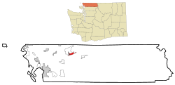
Location of Maple Falls, Washington
|
|
| Country | United States |
| State | Washington |
| County | Whatcom |
| Area | |
| • Total | 3.0 sq mi (7.8 km2) |
| • Land | 3.0 sq mi (7.8 km2) |
| • Water | 0.0 sq mi (0.0 km2) |
| Elevation | 646 ft (197 m) |
| Population
(2020)
|
|
| • Total | 291 |
| • Density | 97.0/sq mi (37.31/km2) |
| Time zone | UTC-8 (Pacific (PST)) |
| • Summer (DST) | UTC-7 (PDT) |
| ZIP code |
98266
|
| Area code | 360 |
| FIPS code | 53-43010 |
| GNIS feature ID | 1522693 |
Maple Falls is a small community located in Whatcom County, Washington, in the United States. It's known as a census-designated place (CDP), which means it's a special area that the government counts for population, but it's not officially a city or town. In 2020, about 291 people lived there.
Contents
Where is Maple Falls?
Maple Falls is found along the Mount Baker Highway. This highway is east of Bellingham. It's also about three miles east of a place called Kendall. From Kendall, another road, State Route 547, goes over a small mountain pass. This road connects to Sumas and the border with Abbotsford, British Columbia in Canada.
The area of Maple Falls covers about 3.0 square miles (7.8 square kilometers). All of this area is land, with no large bodies of water inside its borders.
What's the Weather Like?
The weather in Maple Falls is generally mild. This means there aren't huge differences between the highest and lowest temperatures. It also gets a good amount of rain all year long. This type of weather is called a marine west coast climate. On climate maps, it's often shown as "Cfb."
A Look Back in Time: Maple Falls' History
One of the very first people to settle in Maple Falls was Herbert Everant Leavitt. He was originally from a place called Melbourne in Quebec, Canada. Before coming to Washington, Leavitt worked as a carpenter in Truckee, California.
In 1888, Leavitt decided to start a farm in Whatcom County. This is where Maple Falls is today. He had to carry all his supplies about 30 miles from Bellingham to his new farm. Over the years, besides farming, Leavitt did many other jobs. He ran a blacksmith shop in Maple Falls. He also owned a restaurant in Bellingham. Plus, he managed two hotels. For about 24 years, he even worked as a county constable, which is like a local police officer.
Who Lives in Maple Falls?
The population of Maple Falls changes over time. In 2010, there were 324 people living there. By the 2020 census, the population was 291 people.
In 2000, there were 277 people living in Maple Falls. There were 109 households, which are groups of people living together in one home. Out of these, 70 were families.
The average household had about 2.54 people. The average family had about 3.04 people.
The ages of the people in Maple Falls varied. About 27.4% of the population was under 18 years old. About 32.5% were between 25 and 44 years old. And about 10.8% were 65 years old or older. The average age was 36 years.
See also
 In Spanish: Maple Falls (Washington) para niños

