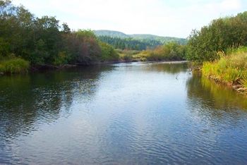
Margaree River facts for kids
Quick facts for kids Margaree River |
|
|---|---|

The Margaree River at Gillisdale
|
|
| Country | Canada |
| Province | Nova Scotia |
| Physical characteristics | |
| River mouth | Gulf of Saint Lawrence sea level 46°25′38.3″N 61°5′50.4″W / 46.427306°N 61.097333°W |
| Length | 120 km (75 mi) |
| Basin features | |
| Basin size | 1,375 km2 (531 sq mi) |
The Margaree River is a beautiful river located on Cape Breton Island in Nova Scotia, Canada. It's about 120 kilometers (75 miles) long. This river is famous for its amazing fishing, especially for Atlantic salmon and trout. People come from all over to fish here!
About the Margaree River
The Margaree River has two main parts. The northeast branch starts in the Cape Breton Highlands. The Southwest Margaree flows from Lake Ainslie. These two branches meet at a place called Margaree Forks. From there, the river flows north. It finally empties into the Gulf of Saint Lawrence at Margaree Harbour, Nova Scotia.
The river is 120 kilometers (75 miles) long. It drains an area of 1,375 square kilometers (531 square miles).
Fishing Fun
For over a hundred years, the Margaree River has been known for its excellent fishing. Anglers (people who fish with a rod and line) love to catch trout and Atlantic salmon here. Fishing rules are very strict now to protect the fish. You can only use fly fishing methods. Also, hooks must be barbless, meaning they don't have a barb to hold the fish. This makes it easier to release fish safely.
A famous American angler named Lee Wulff caught his very first salmon using a fly on the Margaree River in 1933.
Home to Wildlife
The upper part of the Northeast Margaree River has special gravel bars. These are important places where Atlantic salmon lay their eggs. The river's steep valleys provide homes for animals like the American marten. You might also find the rare Gaspé shrew here. The Margaree Valley itself has a mix of farms and woodlands.
A River with History
In the 1700s, Acadian people settled along the coast near the river's mouth. They called this river St. Marguerite. Later, in the early 1800s, people from Scottish Highlands began to settle in the Margaree Valley.
A well-known person from the Margaree Valley was Moses Coady. He went to school in Margaree Forks. He even taught there before continuing his education in Antigonish and Rome.
A Special River
In 1998, the Margaree River was given a special title. It was named a Canadian Heritage River. This means it's recognized for its natural beauty, history, and importance to Canada.
A Canadian naval destroyer from World War II was also named after this river. It was called HMCS Margaree.
 | Anna J. Cooper |
 | Mary McLeod Bethune |
 | Lillie Mae Bradford |

