
Markeaton Brook facts for kids
Quick facts for kids Markeaton Brook |
|
|---|---|

Confluence of the Markeaton Brook with the River Derwent in Derby
|
|
| Country | England |
| Counties | Derbyshire |
| Villages | Mercaston, Kedleston, Markeaton |
| City | Derby |
| Physical characteristics | |
| Main source | Hulland, Derbyshire 53°00′00″N 1°37′01″W / 53.000°N 1.617°W |
| River mouth | Derby, Derbyshire 52°55′12″N 1°27′54″W / 52.920°N 1.465°W |
| Length | 17 km (11 mi) |
| Basin features | |
| Basin size | 64 km2 (25 sq mi) |
| Tributaries |
|
| Progression : Markeaton Brook—Derwent—Trent—Humber | |
The Markeaton Brook is a 17-kilometer (about 10.5 miles) long stream in Derbyshire, England. It flows into the River Derwent. The brook starts south of Hulland Ward. It flows mostly through the countryside north-west of Derby.
Before it reaches the city center, the brook goes into a hidden tunnel called a culvert. It then comes out on the other side of Derby and joins the River Derwent.
Long ago, the Markeaton Brook flowed openly through Derby. Over time, bridges were built over it, and then it was covered up with pipes. By the Victorian era, it was almost completely hidden. Today, it flows unseen beneath the city center.
Even though it's hidden, the brook has caused many floods in Derby. Because of this, parts of the brook were changed, and special tunnels were built to help prevent future floods.
Contents
Where Does the Markeaton Brook Flow?
The Markeaton Brook starts south of Hulland Ward. It flows south-east and is joined by the Black Brook near Mercaston. At first, it's even called the Black Brook!
South of Weston Underwood, its name changes to Cutler Brook. It then flows through the beautiful parkland of Kedleston Hall. In the 1700s, the stream here was changed to create a series of lakes, making the park even prettier.
Beside the top lake, there's a fancy boathouse and a fishing room. Further on, a "very handsome stone bridge" crosses the brook, where the water also falls over a small waterfall.
The Cutler Brook continues south-east. It meets a smaller stream from Quarndon, and that's when its name officially becomes the Markeaton Brook. The brook then flows into Markeaton Park. Here, its biggest helper, the Mackworth Brook, joins it. The Mackworth Brook drains water from areas like Mackworth and Kirk Langley.

Inside Markeaton Park, the brook splits into different paths. Some water goes into Markeaton Lake. All the channels eventually rejoin at Britannia Mill. From there, the brook continues through the West End of Derby.
The brook then enters the Markeaton Brook Culvert at Ford Street. This long tunnel takes the brook under the center of Derby, flowing beneath streets like the Strand and Victoria and Albert Street. Another hidden stream, the Bramble Brook, joins it underground.
Finally, the Markeaton Brook comes out of the culvert near the Cockpit island. It then flows alongside the Bass recreation ground before meeting the River Derwent.
Understanding the Brook's Water Area
The Markeaton Brook and its smaller streams collect water from an area of 64 square kilometers (about 25 square miles). This area is north-west of Derby.
The amount of rain in this area is about 750 millimeters (30 inches) per year. This is a bit less than the average rainfall for all of England. The highest point in the area where the brook collects water is 212 meters (696 feet) high, near Crossways farm.
During a big storm, the brook can carry a huge amount of water, about 50 cubic meters (1,766 cubic feet) per second! This can happen within thirteen hours of heavy rain. In summer, the flow is much smaller, only about 0.35 cubic meters (12 cubic feet) per second.
The ground in the brook's water area is mostly made of Siltstone and a type of mudstone. Some areas in the upper parts have Sandstone and Shale. The Environment Agency has named the section from Markeaton Park to the River Derwent a "main river."
Mills Powered by the Brook
The Markeaton Brook was very important for powering water mills long ago. There were more than twelve possible mill sites along its path. Some of these mills were even mentioned in the Domesday Book, a famous survey from 1086, which said Derby had ten mills.

Most of these old mills are now gone. However, the mill at Mercaston is still standing and is now a private house. Britannia Mill is now part of The University of Derby.
Another mill, Nun's Mill, was in Derby. It was even mentioned as a landmark in descriptions of the old "mob football" games played in Derby until the 1700s.
History of Floods in Derby
Derby has a long history of floods because it's located where the River Derwent and the Markeaton Brook meet.
In the 1800s, a historian named Glover wrote about many past floods. Some of the earliest floods from the Markeaton Brook date back to 1610. In that year, three prisoners in the old Derby jail drowned. The jail had underground cells that filled with floodwaters when the brook suddenly rose.
St Werburgh's Church, Derby, which is right next to the brook, was often damaged by floods. For example, in 1673, a "great flood" on the Markeaton Brook carried away hay, filled cellars, and broke down three bridges. In 1698, another "great flood" even washed down part of the church and its steeple! The church faced more floods in the 1700s and 1800s.

In December 1740, Derby had a huge flood. It was caused by a lot of snow and rain. Streets and ground-floor rooms were deep underwater. Houses and furniture were damaged, walls fell, and many animals were swept away. St. Werburgh's Church was so damaged that its floor had to be completely repaved.
The church floor also needed repairs after the biggest flood in the 1800s, which happened in April 1842. Herbert Spencer, an engineer in Derby at the time, described this flood. He said the Markeaton Brook rose very high because of heavy rain. The main street was flooded about six feet deep! He wrote a report for the Town Council with ideas to prevent future floods.
You can still see an iron flood mark from 1842 on the Wardwick Tavern. The deepest part of that flood was recorded as six feet deep in Willow Row. The damage from these floods was estimated at £15,000, which would be a huge amount of money today!
In the early 1930s, two more major floods happened. These floods made people realize they needed a permanent solution to protect Derby. The first was in September 1931. Heavy rain caused the brook to flood the town center. People were trapped in their homes, and crops from gardens were swept through the streets.
The second flood happened less than a year later, in May 1932. Again, heavy rain caused the brook to overflow. Shops in the city center were flooded up to their windows. The center of town looked like a big lake.
After this flood, the Mayor of Derby started a fund to help those affected. A souvenir booklet was even sold to raise money. The damage to the town was estimated at £400,000, which would be an enormous amount of money today.
How Flood Relief Culverts Help
-by-Noel-Jenkins.jpg)
After the big floods of 1931 and 1932, the city council decided to find a way to stop future floods. Their plan was to build two large tunnels, called flood relief culverts. They also improved the sewer system.
The biggest tunnel, called the Northern Flood Relief Culvert, opened in 1938. It helps carry away extra water from the Markeaton and Mackworth brooks during heavy rains. The second tunnel, the Bramble Brook culvert, does the same for that stream.
The Northern Flood Relief Culvert starts in Markeaton Park, where the Markeaton and Mackworth brooks meet. Each brook has its own special entrance with a weir (a small dam) that overflows when water levels are high. The water from these entrances then flows into the main culvert.
This culvert goes east for 2.2 kilometers (about 1.4 miles) under the suburbs of Derby. It then empties into the River Derwent in Darley Park. In 2006, the entrances were improved to handle changes in how water flows into the brook's area.
Wildlife and Nature in the Brook
The Markeaton Brook and its smaller streams are home to many different plants and animals. There are two special protected areas for nature: Muggington Bottoms and Kedleston Hall.
Rare freshwater sponges have been found in the brook. Also, the endangered native white-clawed crayfish lives here. These are important creatures that need protection.
Working Together for the Brook
Since 2004, a big project has been working to protect the Markeaton and Mercaston brooks. This project aims to reduce mud flowing into the water, restore natural hedges, and fight against harmful plants and animals that don't belong there, like American mink and Himalayan balsam.
A group called the Friends of the Markeaton Brook is part of this project. They work to protect the brook and its surroundings. They also teach people about the brook's history, its uses, and the nature that lives there.
Images for kids
-
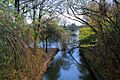
Confluence of the Markeaton Brook with the River Derwent in Derby
-
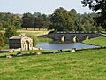
Kedleston Hall - Boat House and Bridge, where the brook has been landscaped into a series of lakes.
-
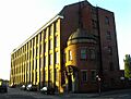
The former Britannia Mill
-
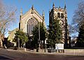
The former St Werburgh's Church and Tower
-
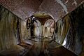
Northern Flood Relief Culvert showing the intersection of the tunnels from the Markeaton and Mackworth brooks
