Markleton, Pennsylvania facts for kids
Quick facts for kids
Markleton, Pennsylvania
|
|
|---|---|
|
Unincorporated community
|
|
| Country | United States |
| State | Pennsylvania |
| County | Somerset |
| Elevation | 1,693 ft (516 m) |
| Time zone | UTC-5 (Eastern (EST)) |
| • Summer (DST) | UTC-4 (EDT) |
| ZIP code |
15551
|
| Area code(s) | 814 |
| GNIS feature ID | 1180426 |
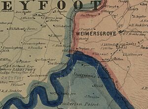
Markleton is a small community in Somerset County, Pennsylvania, in the United States. It's not an official town with its own government, but a group of homes and buildings. You can find it close to the Casselman River, about 7.7 miles (12.4 km) east-northeast of a place called Confluence.
Contents
History of Markleton
Markleton has an interesting past, changing names and purposes over the years.
Early Days: Philson's Forge
The area was first known as Philson's Forge. This name came from a special type of furnace called a Catalan forge. Robert Philson built this forge near the Casselman River around 1810. It was used to make iron. However, the forge didn't do well and closed around 1823.
Markle Paper Works: A Paper Mill
Markleton got its current name from a paper company. This company was called Cyrus P. Markle & Sons. They were from West Newton in nearby Westmoreland County. In 1881, C.P. Markle & Sons bought 5,000 acres of land. This land was along the Casselman River.
They built a paper mill there. Their goal was to use the many trees from the mountains to make paper products. They even bought over 1,000 acres from another company. The paper mill had thirteen two-story houses for workers. It also had a home for the boss and a place for people to stay. But the paper mill didn't make much money, so it didn't last long.
Markleton Sanatorium: A Health Resort
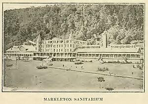
In late 1886, William J. Hitchman bought the Markle buildings and land. He wanted to create a place for vacations and health treatments. He teamed up with Dr. Matthew B. Gault and Rev. John Morrison Barnett. Together, they formed the Markleton Hotel Company. It was officially called the "Markleton Sanitarium and Hotel Company."
Dr. Gault was a medical expert. Rev. Barnett was a Presbyterian minister and a financial manager. They turned the two main paper mill buildings into a large hotel. The old workers' houses became private cottages for guests.
The Markleton Sanatorium was a popular spot. In 1905, it could hold 150 guests. It also hosted meetings for different medical groups.
U.S. Army General Hospital No. 17
When the United States joined World War I, the government used the sanatorium. It became U.S. Army General Hospital No. 17. The Army rented the buildings on February 25, 1918. Staff arrived in March, and the hospital opened in April.
This hospital was special. It treated soldiers who had tuberculosis, a lung disease. The Army needed places to treat these patients. Markleton was chosen even though it was small. This was because few owners wanted to rent their buildings for tuberculosis treatment.
The hospital also helped soldiers recover fully, both mentally and physically. It could care for 200 patients. The hospital stayed full until it closed on March 27, 1919. The patients and staff even made a newspaper called Star Shell. Many doctors and nurses worked there to help the soldiers.
Nearby Historical Railroad Tunnels
Just downstream from Markleton, several railroad tunnels were built. They helped trains travel along the Casselman River.
Pinkerton Tunnels
Pinkerton Point is a part of the mountain that sticks out. The Baltimore & Ohio Railroad (B&O) built a tunnel through it in 1871. In 1879, a fire destroyed this tunnel. So, a new rail line was built around the point. The tunnel was rebuilt and opened again in 1885.
Later, the Western Maryland Railway built another tunnel through Pinkerton Point in 1911. This track was on the other side of the river. So, two bridges were also built. These bridges allowed trains to cross the river, go through the mountain, and cross back. Today, this path is part of the Great Allegheny Passage, a popular rail trail.
Shoo Fly Tunnel
Another tunnel nearby is called the Shoo Fly Tunnel. Pictures of it were published in a book in 1872. The tunnel was improved in 1897 and 1902.
Daylighting Tunnels
In 2012, the B&O Pinkerton Tunnel and the Shoo Fly Tunnel were "daylighted." This means parts of the tunnels were opened up. It was done as part of a big project called the National Gateway.
Geography of Markleton
Markleton is located in the southeastern part of Upper Turkeyfoot Township. You can find it along Markleton School Road. It is east of Pennsylvania Route 281. The village of Kingwood is to the north, and Fort Hill is to the south.
Mount Zion Cemetery is on a hill above Markleton. It's next to the old Mt. Zion United Brethren Church, which started in 1889.
Markleton has a post office with the ZIP code 15551. The post office is on the west side of the Casselman River. It's between the river and the CSX Transportation rail line. Across the river, there's a place to access the Great Allegheny Passage rail trail. This is the only place with parking for the trail between Fort Hill and Rockwood.
 | James B. Knighten |
 | Azellia White |
 | Willa Brown |


