Marlborough, Queensland facts for kids
Quick facts for kids MarlboroughQueensland |
|||||||||||||||
|---|---|---|---|---|---|---|---|---|---|---|---|---|---|---|---|

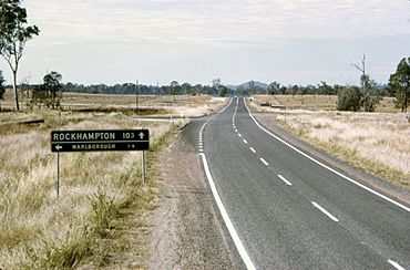
:Turn off to the town of Marlborough from the Bruce Highway, 1970s
|
|||||||||||||||
| Population | 154 (2021 census) | ||||||||||||||
| • Density | 0.1109/km2 (0.287/sq mi) | ||||||||||||||
| Postcode(s) | 4705 | ||||||||||||||
| Area | 1,388.9 km2 (536.3 sq mi) | ||||||||||||||
| Time zone | AEST (UTC+10:00) | ||||||||||||||
| Location |
|
||||||||||||||
| LGA(s) | Shire of Livingstone | ||||||||||||||
| State electorate(s) | Mirani | ||||||||||||||
| Federal Division(s) | Capricornia | ||||||||||||||
|
|||||||||||||||
Marlborough is a small country town and coastal area in Queensland, Australia. It's part of the Livingstone Shire. In 2021, about 154 people lived here.
Contents
Exploring Marlborough's Location
Marlborough is located on the Bruce Highway, about 106 kilometers (66 miles) northwest of Rockhampton. It's a handy stop for travelers, offering fuel and services along this long highway.
Natural Resources and Gems
South of Marlborough, you'll find the Kunwarara Magnesite mine. Magnesite is a mineral used in many things, like making bricks for furnaces or even some medicines. This mine has one of the largest supplies of magnesite in the world.
Marlborough is also famous for a special gem called chrysoprase. This beautiful, semi-precious stone was once loved by famous historical figures like Alexander the Great and Cleopatra. The chrysoprase found near Marlborough is considered the best and most valuable in the world. It comes from a small but very rich deposit about 20 kilometers (12 miles) south-south-west of the town.
Roads and Railways
The Bruce Highway goes through the Marlborough area. It enters from the east (near Kunwarara) and leaves to the north-west (towards Ogmore). The highway actually goes around the town, about 1 kilometer (0.6 miles) to the west.
The North Coast railway line also runs through the area, mostly parallel to the highway. However, the railway line does go through the town itself. Marlborough has its own train station, called Marlborough railway station (22°48′50″S 149°53′21″E / 22.8140°S 149.8893°E).
The Marlborough–Sarina Road starts here and heads west.
Marlborough's Past
Marlborough began as a large farming area in 1857. It was set up by Dan Connor. The name "Marlborough" likely comes from the First Duke of Marlborough (1650-1722), who was a famous British army leader.
Early Services and Buildings
The post office in Marlborough opened on January 1, 1861. The first plots of land for building homes and businesses in the town were sold in 1862.
From 1865 to 1876, Marlborough was home to a Native Police barracks. This was a station for a police force that operated in colonial Australia. The barracks were located at Barrack Creek, just outside the north-west part of town.
School History
The Marlborough Railway Provisional School first opened its doors on July 26, 1917. It changed its name to Koonama Provisional School in 1919 and then to Koonama State School in 1920. Finally, on September 11, 1925, it became Marlborough State School, which is its name today.
Community Spirit
On July 24, 2000, a sad event occurred when a rescue helicopter crashed in a field near Marlborough during thick fog. Five people lost their lives. After this tragedy, the people of Marlborough worked together to raise money. They built a permanent helipad in the town. This was done to help prevent similar accidents from happening again in the future.
Marlborough is currently part of the Shire of Livingstone local government area. For a few years, between 2008 and 2013, it was part of the Rockhampton Region.
Population Details
In 2016, the population of Marlborough was 149 people. By 2021, the number of people living in Marlborough had grown slightly to 154.
Learning in Marlborough
Marlborough State School is a government primary school for students from early childhood up to Year 6. It is located on Magog Road (22°48′42″S 149°53′42″E / 22.8118°S 149.8950°E). In 2018, the school had 34 students and 5 teachers.
The students at Marlborough State School often compete against other local schools like Clarke Creek State School and Milman State School. They take part in swimming and athletics events, which Marlborough often hosts. The school has a 16-meter swimming pool and a grassy oval for sports.
There isn't a secondary school (high school) in Marlborough. The closest government high school is Glenmore State High School in Kawana, Rockhampton, which is over 100 kilometers (62 miles) away. For older students, options include distance education (learning from home) or attending boarding schools.
Community Services
Library Services
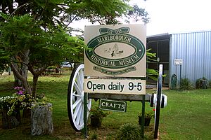
The Livingstone Shire Council provides a weekly library service in Marlborough. It is located at 15 Milman Street (22°48′46″S 149°53′30″E / 22.8129°S 149.8916°E), inside the Marlborough Historical Museum building.
Local Church
All Saints Anglican Church is located at 27 Milman Street (22°48′48″S 149°53′35″E / 22.8133°S 149.8930°E). It is part of the Parish of North Rockhampton, which is also known as the All Saints Anglican Community. This church belongs to the Anglican Church of Central Queensland.
Places to Visit
The Marlborough Historical Museum is at 15 Milman Street (22°48′46″S 149°53′29″E / 22.8128°S 149.8915°E). This museum collects and shares the natural and social history of Marlborough. It's a great place to learn about the area's past and its unique heritage.
 | Sharif Bey |
 | Hale Woodruff |
 | Richmond Barthé |
 | Purvis Young |


