Marulan facts for kids
Quick facts for kids MarulanNew South Wales |
|||||||||||||||
|---|---|---|---|---|---|---|---|---|---|---|---|---|---|---|---|
| Population | 1,178 (2016 census) | ||||||||||||||
| Established | 1868 | ||||||||||||||
| Postcode(s) | 2579 | ||||||||||||||
| Elevation | 642 m (2,106 ft) | ||||||||||||||
| Location | |||||||||||||||
| LGA(s) | Goulburn Mulwaree Council | ||||||||||||||
| County | Argyle | ||||||||||||||
| Parish | Marulan | ||||||||||||||
| State electorate(s) | Goulburn | ||||||||||||||
| Federal Division(s) | Hume | ||||||||||||||
|
|||||||||||||||
Marulan is a small town in the Southern Highlands of New South Wales, Australia. It is located east of the Great Dividing Range. The town is part of the Goulburn Mulwaree Council area. It sits on the traditional lands of the Gundungurra people.
Marulan is found southwest of Sydney on the Hume Highway. However, the highway now goes around the main part of the town. An interesting fact about Marulan is that it lies exactly on the 150th meridian east. This is an important line for time zones. The town also has a railway station on the Main Southern railway line. In the past, Marulan was known by the name Mooroowoolen.
In 2016, a count showed that 1,178 people lived in Marulan.
Contents
History of Marulan
Early European Exploration
When Europeans first settled in Sydney, they explored slowly towards the southwest. In 1818, explorers Hamilton Hume and James Meehan reached the area known as "the Goulburn plains".
The Governor at the time, Lachlan Macquarie, ordered a major road to be built in 1819. This road, called the Great South Road, went from Picton to the Goulburn Plains. It later became the start of the Hume Highway.
Roads and Development
The southern part of Governor Macquarie's road went through places like Sutton Forest and Towrang. It eventually joined the path to Goulburn. In the 1820s, another road developed from Sutton Forest to Bungonia. This road passed through areas like Wingello and Tallong. Bungonia was once thought to become a big town, but it wasn't good for farming.
In the 1830s, explorer Thomas Mitchell changed the route of the Great South Road. He decided to bring these two roads together at a place called old Marulan. From there, roads would go to Goulburn and Bungonia.
The Railway Arrives
When the Main Southern railway line reached Marulan in 1868, the town actually moved! The main part of the town shifted about 3 kilometers north to be closer to the new railway station. Even today, the old cemetery is still located at the original Bungonia Road intersection. A large quarry is being built near this old intersection, so a new road interchange has been constructed there.
In 1958, the first station in New South Wales for checking trucks was opened near Marulan on the Hume Highway. Later, in 1986, a new section of the Hume Highway with two lanes in each direction was opened. This new road bypassed the town, meaning traffic no longer had to drive through Marulan itself.
Marulan Meridian Arch
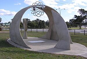
The Marulan Meridian Arch is a special sculpture found in Meridian Park on George Street. It looks like an arch with a metal ball on top. This arch marks the exact center of the UTC+10:00 time zone. This means that on the equinox (when day and night are equal length), the sun rises around 6:00 AM and sets exactly at 6:00 PM in Marulan.
The arch was built to celebrate the 100th birthday of the Federation of Australia. It also highlights that Marulan is the only town located right on the 150th meridian east.
Heritage-Listed Places
Marulan has several places that are important to its history and are protected as heritage sites. These include:
- Old Marulan Town
- Wandi, located at 16501 Hume Highway, Narambulla Creek
- Marulan railway station, part of the Main Southern railway line
 | Bessie Coleman |
 | Spann Watson |
 | Jill E. Brown |
 | Sherman W. White |


