Mascarene Plateau facts for kids
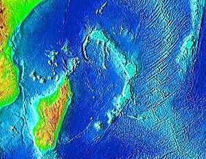
The Mascarene Plateau is a huge underwater area in the Indian Ocean. It's like a giant, flat shelf hidden beneath the waves, located north and east of Madagascar. This amazing plateau stretches about 2,000 kilometers (1,240 miles) from the Seychelles in the north all the way to Réunion in the south.
It covers more than 115,000 square kilometers (44,400 square miles) of shallow water. Most of it is only 8 to 150 meters (26 to 490 feet) deep. But at its edges, the seafloor drops sharply to depths of 4,000 meters (13,000 feet)! It is the second-largest underwater plateau in the Indian Ocean, right after the Kerguelen Plateau.
Contents
Where is the Mascarene Plateau Located?
The Mascarene Plateau is home to many interesting islands and underwater features. In its northern part, you'll find the Agaléga Islands and the beautiful Seychelles Islands.
The southern part includes places like Hawkins Bank, the Mascarene Islands, Nazareth Bank, the Saya de Malha Bank, and the Soudan Banks. The Mascarene Islands themselves are a group of mountainous islands. These include the Cargados Carajos Shoals, Mauritius, Réunion, and Rodrigues.
How Did the Mascarene Plateau Form?
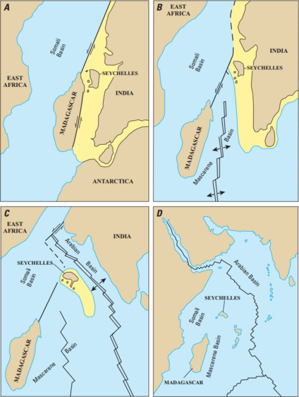
Long, long ago, the landmass that is now India was actually next to what we now call the Seychelles. Over millions of years, the Earth's crust slowly moved apart. This process, called seafloor spreading, pushed India to its current spot. Eventually, it joined with the continent of Asia.
Ancient Continents and Granite Rocks
The northern part of the Mascarene Plateau is made of a hard rock called granite. This granite is a piece of a very old supercontinent named Gondwana. On top of this granite, you can find layers of limestone and basalt.
The basalt rocks in the Seychelles came from a massive volcanic event. This event, known as the Deccan Traps eruption, happened about 66 million years ago. It marked the end of the Cretaceous period.
Volcanoes and Coral Reefs
The southern part of the Mascarene Plateau formed in a different way. It was created by a special place deep inside the Earth called the Réunion hotspot. This hotspot also helped form the Chagos–Laccadive Ridge.
Many of the underwater banks and shoals in the southern plateau were once volcanic islands. They were similar to Mauritius and Réunion today. Over time, these islands either sank below the sea or were worn away by erosion. Some, like the Cargados Carajos, are now low coral islands.
For example, the Saya de Malha Bank formed about 35 million years ago. The Nazareth Bank and the Cargados Carajos shoals appeared later. The limestone banks on the plateau are what's left of old coral reefs. This tells us that the plateau was once a chain of many islands.
Some of these banks might have been islands as recently as 18,000 to 6,000 years ago. This was during the last ice age, when sea levels were much lower. Mauritius formed 8 to 10 million years ago. Rodrigues and Réunion are much younger, forming around two million years ago. Today, the Piton de la Fournaise volcano on Réunion is one of the most active volcanoes in the world.
See also
- Central Indian Ridge
- Geography of Seychelles
- Geology of Seychelles
- Mauritia
- Seychelles Microcontinent
 | Emma Amos |
 | Edward Mitchell Bannister |
 | Larry D. Alexander |
 | Ernie Barnes |


