
Mason–Dixon line facts for kids
The Mason–Dixon line, also known as Mason's and Dixon's line, was a special border surveyed between 1763 and 1767. It was originally meant to separate the colonies of Maryland and Pennsylvania. Two English surveyors, Charles Mason and Jeremiah Dixon, were hired for this important job.
They were chosen by the Penn and Calvert families to help end a long-standing argument over their land boundaries. In 1760, the British king was tired of the fighting between the two colonies. He ordered them to settle their border dispute based on an agreement made in 1732. The line Mason and Dixon created was incredibly accurate. Even today, with modern GPS technology, we see it's usually off by only an inch or less.
Contents
Why Was the Mason-Dixon Line Needed?

To understand why the Mason-Dixon line was so important, we need to look back at how the colonies of Maryland and Pennsylvania were started.
The Story of Maryland
In England, a man named George Calvert was a powerful government official. In 1625, he announced he was a Catholic. Because of English law at the time, he had to leave his job. The king then made him "Lord Baltimore."
Lord Baltimore was interested in starting new settlements across the ocean. He first tried to start a colony called "Avalon" in Newfoundland. But he soon lost interest. He then convinced King Charles I of England to give him land to start a new colony called Maryland. The king gave Calvert and his son all the land north of the Potomac River up to the 40th parallel. This land also stretched from the Atlantic Ocean to the source of the Potomac. Lord Baltimore died in 1632, but his sons went on to establish the Maryland colony. In 1634, about 300 settlers arrived at St. Mary's City, Maryland on the Chesapeake Bay.
The Story of Pennsylvania
William Penn was a leader of the Religious Society of Friends, also known as Quakers. In 1677, he was granted land for the colony of West Jersey. Penn stayed in England while colonists settled there.
King Charles II of England owed Penn's father a lot of money. When Penn's father died, the king repaid the debt by giving William Penn a huge area of land. This land was west and south of New Jersey. Penn called it "Sylvania," which means "woods" in Latin. King Charles II renamed it Pennsylvania in honor of Penn's father. The king might have been happy to send political groups like the Quakers far away from England. The official boundaries for Pennsylvania were set on March 4, 1681.
The Big Border Fight

In 1682, a mistake happened during a land survey. The city of Philadelphia ended up being placed inside the land that was supposed to belong to Maryland. This meant the land grants for Maryland and Pennsylvania overlapped. The Calvert family in Maryland demanded that Philadelphia become part of their colony. The Penn family disagreed and defended their claim. In 1729, they even created Lancaster County, Pennsylvania, partly to protect this disputed area.
Maryland hired a tough man named Thomas Cresap to push their claim. He and his armed followers moved up the Susquehanna River. They settled on the west bank near the 40th parallel. From there, they started bothering their Pennsylvania neighbors. They killed farm animals and tore down fences.
In 1732, the fighting calmed down when the two colonies agreed on a solution. But Lord Baltimore changed his mind two years later. Cresap and his men started raiding farms again. They told Pennsylvania Quakers they had to pay taxes to Maryland if they wanted the attacks to stop.
The closest this dispute came to being a real "war" was on November 23, 1736. A group of men from Pennsylvania, led by the Sheriff of Lancaster, attacked Cresap's men. The Maryland group was defeated, and one person was killed. Cresap was arrested and taken to Philadelphia. He stayed in prison until August 1737. Then, the King ordered his release. He also told the two colonies to settle their argument in court, not by fighting.
An English high court made a decision in 1750. They ruled in favor of Pennsylvania. The court said that Maryland lost its rights to the disputed land when it agreed to the compromise in 1732. The new border was set at 39 degrees, 43 minutes, 26.3 seconds north latitude. This was based on the survey that Mason and Dixon would later complete.
How the Mason-Dixon Line Connected to Slavery
In 1781, Pennsylvania decided to end slavery. Because of this, the original Mason-Dixon line became a rough dividing line. It separated the Southern states, which allowed slavery, from the Northern states, which did not. The only exception was Delaware, which remained a slave state until the American Civil War.
Fifty years later, the Missouri Compromise of 1820 created a new line. This line extended the Mason-Dixon line westward to the Ohio River. It then followed the border of Ohio to the Mississippi River, and then went westward along 36 degrees 30 minutes North.
So, the line that started as a way to end a border argument became famous for something else entirely. It became known as the line that separated states where slavery was allowed from those where it was not.
Images for kids
-
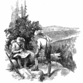
Illustration of Charles Mason and Jeremiah Dixon surveying the line
-
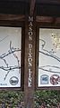
The Mason–Dixon line where the Torrey C. Brown Rail Trail meets the York County Heritage Trail
-
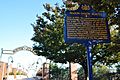
A historical marker in Philadelphia, Pennsylvania, showing the starting point for the survey
-
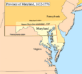
A map of the Province of Maryland, from 1632 to 1776
-
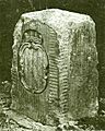
A "crownstone" boundary marker on the Mason–Dixon line. These stones were placed every 5 miles and had the coats of arms of the Penn and Calvert families.
-
"A Plan of the West Line or Parallel of Latitude" drawn by Charles Mason in 1768


.jpg)


See also
 In Spanish: Línea Mason-Dixon para niños
