Masontown, Pennsylvania facts for kids
Quick facts for kids
Masontown, Pennsylvania
|
||
|---|---|---|
|
Borough
|
||
|
||
| Etymology: John and Abigail Mason | ||

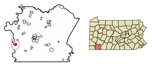
Location of Masontown in Fayette County, Pennsylvania.
|
||
| Country | United States | |
| State | Pennsylvania | |
| County | Fayette | |
| Established | 1798 | |
| Area | ||
| • Total | 1.53 sq mi (3.95 km2) | |
| • Land | 1.50 sq mi (3.87 km2) | |
| • Water | 0.03 sq mi (0.08 km2) | |
| Elevation | 1,020 ft (310 m) | |
| Population
(2020)
|
||
| • Total | 3,276 | |
| • Density | 2,191.30/sq mi (846.24/km2) | |
| Time zone | UTC-4 (EST) | |
| • Summer (DST) | UTC-5 (EDT) | |
| ZIP code |
15461
|
|
| Area code(s) | 724 | |
Masontown is a small town, also called a borough, located in Fayette County, Pennsylvania, in the United States. It's part of the larger Pittsburgh Metro Area. In 2020, about 3,274 people lived here. The town is served by the Albert Gallatin Area School District. Masontown acts as a central point for the countryside around it, with a small shopping area and a grocery store.
Contents
History of Masontown
Masontown has a long history, starting even before it became an official town.
Early Beginnings: Fort Mason
From 1774 to 1778, a special building called Fort Mason was built here. A blockhouse is a strong, small fort, often made of logs, used for defense. It was built by a man named John Mason, also known as Johannes Phillip Maurer.
Becoming a Town
Masontown officially became a town in 1798. John Mason, who helped start the settlement, later moved to Ohio. He is buried on a family farm in Columbiana County.
Geography of Masontown
Masontown is located in the southwestern part of Fayette County.
Location and Rivers
The western edge of the borough touches the Monongahela River. This river also forms the border with Greene County. The main part of Masontown is about 1 mile (1.6 km) east of the river and sits about 200 feet (61 meters) higher.
Roads and Routes
Two important roads pass through Masontown:
- Pennsylvania Route 21 goes through the northern and western parts of town. If you go east on this road, you'll reach Uniontown, which is the county seat, about 12 miles (19 km) away. Going west, it crosses the Monongahela River and leads to Waynesburg, about 16 miles (26 km) away.
- Pennsylvania Route 166 runs through the center of Masontown, known as Main Street. This road leads south about 10 miles (16 km) to Point Marion. Point Marion is where the Monongahela River meets the Cheat River.
Area Size
Masontown covers a total area of about 4.00 square kilometers (1.53 square miles). Most of this area, about 3.91 square kilometers (1.50 square miles), is land. The rest, about 0.08 square kilometers (0.03 square miles), is water.
Population of Masontown
| Historical population | |||
|---|---|---|---|
| Census | Pop. | %± | |
| 1880 | 376 | — | |
| 1890 | 391 | 4.0% | |
| 1900 | 466 | 19.2% | |
| 1910 | 890 | 91.0% | |
| 1920 | 1,525 | 71.3% | |
| 1930 | 3,873 | 154.0% | |
| 1940 | 3,721 | −3.9% | |
| 1950 | 4,550 | 22.3% | |
| 1960 | 4,730 | 4.0% | |
| 1970 | 4,226 | −10.7% | |
| 1980 | 4,909 | 16.2% | |
| 1990 | 3,759 | −23.4% | |
| 2000 | 3,611 | −3.9% | |
| 2010 | 3,450 | −4.5% | |
| 2020 | 3,274 | −5.1% | |
| 2021 (est.) | 3,228 | −6.4% | |
| Sources: | |||
As of the 2000 census, there were 3,611 people living in Masontown. There were 1,536 households, which are groups of people living together in one home. The average household had about 2.32 people.
The population included people of different ages. About 23.0% of the people were under 18 years old. About 22.9% were 65 years old or older. The median age, which is the middle age of all the people, was 42 years.
Notable People from Masontown
Some well-known people have come from Masontown:
- Frank L. Bowman: A congressman who represented West Virginia.
- Mike Nixon: A long-time coach and scout for the Pittsburgh Steelers football team.
Gallery
See also
 In Spanish: Masontown (Pensilvania) para niños
 | Delilah Pierce |
 | Gordon Parks |
 | Augusta Savage |
 | Charles Ethan Porter |


