Matanuska Peak facts for kids
Quick facts for kids Matanuska Peak |
|
|---|---|

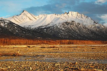
Matanuska Peak (left) from near Palmer
|
|
| Highest point | |
| Elevation | 6,093 ft (1,860 m) |
| Prominence | 993 ft (303 m) |
| Isolation | 2.09 mi (3.36 km) |
| Parent peak | Frontier Peak (6,250 ft) |
| Geography | |
| Location | Matanuska-Susitna Borough Alaska, United States |
| Parent range | Chugach Mountains |
| Topo map | USGS Anchorage C-6 |
| Climbing | |
| Easiest route | trail, class 2 scrambling |
Matanuska Peak is a tall mountain in Alaska, standing at 6,093 ft (1,860 m) high. It is part of the Chugach Mountains range. This peak is a very important landmark in the Matanuska Valley. It is located about 7.5 mi (12 km) east of Palmer.
The name Matanuska Peak was officially approved in 1969. It comes from the Matanuska River. The word "Matanuska" is from a Russian term. It means "copper river people."
Exploring Matanuska Peak
Matanuska Peak is a popular spot for hikers. The Matanuska Peak Trail is a challenging hike. It is five miles long one way. Hikers gain about 5,670 feet in height. Some parts of the trail require a bit of scrambling, which means using your hands and feet to climb.
The best time to climb Matanuska Peak is from June to October. During these months, the weather is usually good. The trails are also free of snow.
Matanuska Peak Challenge
Every August, a tough race called the Matanuska Peak Challenge takes place. This event is for experienced runners. They test their strength and endurance on the mountain.
Climate Around the Peak
Matanuska Peak is in a subarctic climate zone. This means it has long, very cold, and snowy winters. The summers are usually mild. Temperatures can drop very low, sometimes below −20 °C. With the wind, it can feel even colder, below −30 °C.
Water from the peak melts and flows into small streams. These streams then join the Matanuska River. The Matanuska River then flows into the Knik River.
 | Jewel Prestage |
 | Ella Baker |
 | Fannie Lou Hamer |


