Mataquescuintla facts for kids
Quick facts for kids
Mataquescuintla
|
|
|---|---|
|
Municipality
|
|

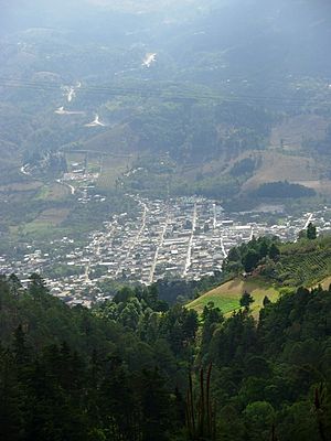
Mataquescuintla seen from Miramundo and Pino Dulce
|
|
| Country | |
| Department | |
| Villa | 1848 |
| Incorporated | 1848 |
| Government | |
| • Type | Mayor–Council |
| • Body | Mataquescuintla municipal council |
| Area | |
| • Total | 262 km2 (101 sq mi) |
| Elevation | 1,727 m (5,000 ft) |
| Population
(2018 census)
|
|
| • Total | 41,848 |
| • Density | 159.73/km2 (413.7/sq mi) |
| • Urban | 9,833 |
| Demonym(s) |
|
| Time zone | UTC-6 (Central America) |
| Climate | Cwb |
| Website | Mataquescuintla municipality |
Mataquescuintla is a town and municipality located in the Jalapa department of south-east Guatemala. It covers about 262 square kilometers (101 square miles).
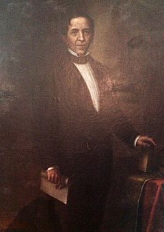
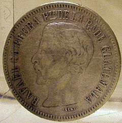
This town was very important in the mid-1800s. It was the main base for a general named Rafael Carrera. He led a revolution of farmers against the government in 1838. Later, he became the ruler of Guatemala from 1840 until he passed away in 1865. Mataquescuintla is divided into 6 areas.
Contents
What's in a Name?
The name "Mataquescuintla" comes from the Nahuatl language. It combines three words:
- "Matatl" means "net bag."
- "Itzcuintli" means "dog."
- "Tlan" means "a place with many" or "abundance."
So, the name "Mataquescuintla" means "net to catch dogs."
History of Mataquescuintla
The first people to settle in Mataquescuintla were the Pipils. They came from the area that is now El Salvador.
Guatemala's Early Years
After Central America became independent, Mataquescuintla was made part of a larger area called Cuilapa in 1825. This was part of the new Constitution of Guatemala.
The Fight for Change (1837-1838)
In 1837, a big fight started against the government of Francisco Morazán. He was the president of the Federal Republic of Central America. This republic included Guatemala, Honduras, El Salvador, Nicaragua, and Costa Rica. People also fought against the leader of Guatemala, Mariano Gálvez.
The leader of this uprising was Rafael Carrera. Many native people joined his forces. The government had brought back old taxes on native populations, which made them angry. Carrera's group used guerrilla warfare, attacking towns quickly.
At the same time, people who didn't like Gálvez spread rumors. They said he was poisoning river water, causing a sickness called cholera morbus. This wasn't true, but it made many people turn against Gálvez and his supporters.
Rafael Carrera led many battles. One important event happened when the government attacked Mataquescuintla. They captured and mistreated Carrera's wife, Petrona Álvarez. When Carrera found out, he promised to get revenge. With his wife by his side, he fought even harder. Petrona Álvarez was very determined and fought fiercely against the government troops.
This fight became like a "holy war." Local priests encouraged farmers to defend their religious rights. They told people to fight against the "liberal atheists" in the government. Carrera himself was taught by a priest in Mataquescuintla.
Another reason for the revolt was that the government had given land and trading rights to the English. Many Guatemalan artisans (craftsmen) became poor because of cheap English goods. Priests told the native people that Carrera was sent from heaven to protect them and restore their old ways. They even created "miracles" to make people believe this. For example, a letter supposedly from the Virgin Mary was dropped from a church roof, telling Carrera to lead the revolt.
To stop the uprising, Gálvez's government used harsh tactics, like destroying crops and homes. But this only made people angrier. By early 1838, the situation in Guatemala was very bad. The economy was suffering. Gálvez left power on January 31, 1838. Rafael Carrera and his "Army of the People" took control of Guatemala City.
Carrera's troops were mostly farmers with simple weapons. They took over government buildings, shouting "Long live religion!" and "Away with foreign heretics!" On March 2, 1838, Rafael Carrera came to power.
New Departments Formed
Guatemala officially became a republic under President Rafael Carrera on March 21, 1847. This allowed Guatemala to trade freely with other countries.
On February 25, 1848, the Mita region was separated from Chiquimula. It became its own department and was divided into three new areas: Jutiapa, Santa Rosa, and Jalapa. Mataquescuintla became part of the Santa Rosa department at that time.
After the Liberal Revolution
After the Liberal Revolution of 1871, new leaders began to tell the story of Carrera's time differently. The important role of Mataquescuintla in Guatemala's history was often overlooked by these new historians.
In 1889, Mataquescuintla was the site of a small uprising. A colonel named Hipólito Ruano led a group against the government. The government quickly stopped the uprising. Ruano was captured and shot in Mataquescuintla Square.
Later, on September 3, 1935, Mataquescuintla moved from the Santa Rosa department to the Jalapa department. On October 29, 1850, Mataquescuintla was officially recognized as a town.
Geography and Climate
Climate of Mataquescuintla
Mataquescuintla has a climate known as Cwb according to the Köppen climate classification. This means it has mild temperatures and a rainy season.
| Climate data for Mataquescuintla | |||||||||||||
|---|---|---|---|---|---|---|---|---|---|---|---|---|---|
| Month | Jan | Feb | Mar | Apr | May | Jun | Jul | Aug | Sep | Oct | Nov | Dec | Year |
| Mean daily maximum °C (°F) | 22.9 (73.2) |
24.0 (75.2) |
25.5 (77.9) |
26.2 (79.2) |
25.6 (78.1) |
24.1 (75.4) |
24.1 (75.4) |
24.3 (75.7) |
23.6 (74.5) |
23.2 (73.8) |
22.7 (72.9) |
22.5 (72.5) |
24.1 (75.3) |
| Daily mean °C (°F) | 17.7 (63.9) |
18.4 (65.1) |
19.3 (66.7) |
20.2 (68.4) |
20.1 (68.2) |
19.4 (66.9) |
19.4 (66.9) |
19.4 (66.9) |
19.0 (66.2) |
18.8 (65.8) |
18.0 (64.4) |
17.4 (63.3) |
18.9 (66.1) |
| Mean daily minimum °C (°F) | 12.5 (54.5) |
12.9 (55.2) |
13.2 (55.8) |
14.2 (57.6) |
14.6 (58.3) |
14.7 (58.5) |
14.7 (58.5) |
14.6 (58.3) |
14.5 (58.1) |
14.4 (57.9) |
13.4 (56.1) |
12.4 (54.3) |
13.8 (56.9) |
| Average precipitation mm (inches) | 8 (0.3) |
10 (0.4) |
18 (0.7) |
42 (1.7) |
192 (7.6) |
319 (12.6) |
243 (9.6) |
238 (9.4) |
301 (11.9) |
194 (7.6) |
41 (1.6) |
15 (0.6) |
1,621 (64) |
| Source: Climate-Data.org | |||||||||||||
Where is Mataquescuintla Located?
Mataquescuintla is located in a central area, surrounded by several other towns and departments.
- To the north are Sansare, Sanarate, and Palencia.
- To the east are San Carlos Alzatate and Jalapa.
- To the south are San Rafael Las Flores, Casillas, Santa Rosa de Lima, and Nueva Santa Rosa.
- To the west is San José Pinula.
It is also very close to Ayarza Lagoon and an old bismuth mine.
 |
Sansare, Sanarate, Palencia |  |
||
| San José Pinula | San Carlos Alzatate, Jalapa | |||
| San Rafael Las Flores, Casillas, Santa Rosa de Lima Nueva Santa Rosa |
See also
 In Spanish: Mataquescuintla para niños
 | Georgia Louise Harris Brown |
 | Julian Abele |
 | Norma Merrick Sklarek |
 | William Sidney Pittman |


