Matsusaka facts for kids
Quick facts for kids
Matsusaka
松阪市
|
|||||||||||||
|---|---|---|---|---|---|---|---|---|---|---|---|---|---|

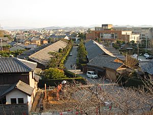
Traditional street in central Matsusaka
|
|||||||||||||
|
|||||||||||||

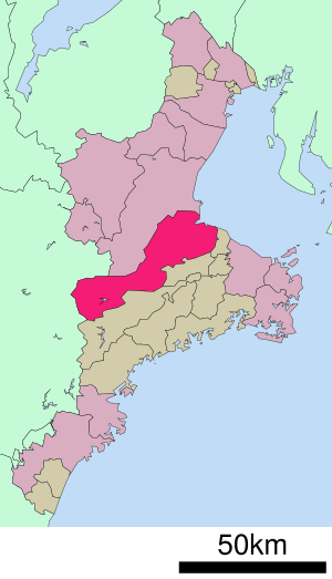
Location of Matsusaka in Mie Prefecture
|
|||||||||||||
| Country | Japan | ||||||||||||
| Region | Kansai | ||||||||||||
| Prefecture | Mie | ||||||||||||
| Area | |||||||||||||
| • Total | 623.64 km2 (240.79 sq mi) | ||||||||||||
| Population
(August 2021)
|
|||||||||||||
| • Total | 157,235 | ||||||||||||
| • Density | 252.1246/km2 (653.000/sq mi) | ||||||||||||
| Time zone | UTC+9 (Japan Standard Time) | ||||||||||||
| Phone number | 0598-53-4311 | ||||||||||||
| Address | 1340-1 Tonomachi, Matsusaka-shi, Mie-ken 515-8515 | ||||||||||||
| Climate | Cfa | ||||||||||||
|
|||||||||||||
Matsusaka is a city in Mie Prefecture, Japan. Its name in Japanese is 松阪市 (Matsusaka-shi). Some people in the local area call it Mattsaka or Massaka.
As of August 2021, about 157,235 people live in Matsusaka. The city covers an area of about 623.64 square kilometers. Matsusaka is very famous for its special Matsusaka beef.
Contents
Exploring Matsusaka's Location
Matsusaka is in the middle of Mie Prefecture, on the eastern side of the Kii Peninsula. It stretches from Ise Bay on the Pacific Ocean in the east all the way to Nara Prefecture in the west. Part of the city is even inside the beautiful Yoshino-Kumano National Park.
Cities and Towns Nearby
Matsusaka shares its borders with several other cities and towns.
In Mie Prefecture, it is next to:
- Tsu
- Taki
- Meiwa
- Ōdai
In Nara Prefecture, it is next to:
- Higashiyoshino
- Kawakami
- Mitsue
Matsusaka's Weather and Climate
Matsusaka has a Humid subtropical climate. This means it has warm summers and cool winters. There is usually not much snow.
The average temperature in Matsusaka is about 14.8 degrees Celsius. The city gets a lot of rain, about 2157.8 millimeters per year. September is usually the wettest month. August is the warmest month, with temperatures around 26.1 degrees Celsius. January is the coldest, with temperatures around 4.2 degrees Celsius.
| Climate data for Kayumi, Matsusaka (1991−2020 normals, extremes 1979−present) | |||||||||||||
|---|---|---|---|---|---|---|---|---|---|---|---|---|---|
| Month | Jan | Feb | Mar | Apr | May | Jun | Jul | Aug | Sep | Oct | Nov | Dec | Year |
| Record high °C (°F) | 19.4 (66.9) |
22.7 (72.9) |
26.5 (79.7) |
31.4 (88.5) |
33.7 (92.7) |
36.1 (97.0) |
38.5 (101.3) |
38.9 (102.0) |
37.3 (99.1) |
31.3 (88.3) |
27.3 (81.1) |
24.8 (76.6) |
38.9 (102.0) |
| Mean daily maximum °C (°F) | 9.4 (48.9) |
10.4 (50.7) |
14.1 (57.4) |
19.6 (67.3) |
24.0 (75.2) |
26.7 (80.1) |
30.8 (87.4) |
31.9 (89.4) |
28.0 (82.4) |
22.4 (72.3) |
17.1 (62.8) |
11.9 (53.4) |
20.5 (68.9) |
| Daily mean °C (°F) | 4.2 (39.6) |
4.7 (40.5) |
8.0 (46.4) |
13.0 (55.4) |
17.8 (64.0) |
21.4 (70.5) |
25.4 (77.7) |
26.1 (79.0) |
22.7 (72.9) |
17.0 (62.6) |
11.2 (52.2) |
6.2 (43.2) |
14.8 (58.7) |
| Mean daily minimum °C (°F) | −0.5 (31.1) |
−0.3 (31.5) |
2.3 (36.1) |
6.8 (44.2) |
12.2 (54.0) |
17.1 (62.8) |
21.3 (70.3) |
21.9 (71.4) |
18.6 (65.5) |
12.4 (54.3) |
6.0 (42.8) |
1.2 (34.2) |
9.9 (49.8) |
| Record low °C (°F) | −7.2 (19.0) |
−6.9 (19.6) |
−5.8 (21.6) |
−3.0 (26.6) |
2.1 (35.8) |
7.2 (45.0) |
13.8 (56.8) |
13.6 (56.5) |
8.8 (47.8) |
1.0 (33.8) |
−3.0 (26.6) |
−6.1 (21.0) |
−7.2 (19.0) |
| Average precipitation mm (inches) | 56.1 (2.21) |
63.0 (2.48) |
115.5 (4.55) |
143.3 (5.64) |
188.4 (7.42) |
231.3 (9.11) |
247.0 (9.72) |
272.3 (10.72) |
400.7 (15.78) |
255.4 (10.06) |
95.9 (3.78) |
61.6 (2.43) |
2,157.8 (84.95) |
| Average precipitation days (≥ 1.0 mm) | 6.5 | 7.3 | 10.7 | 10.0 | 10.7 | 13.7 | 13.1 | 11.4 | 12.8 | 10.7 | 6.9 | 6.7 | 120.5 |
| Mean monthly sunshine hours | 153.3 | 139.1 | 172.2 | 182.8 | 185.8 | 124.5 | 152.2 | 184.6 | 138.2 | 144.2 | 146.2 | 151.8 | 1,875 |
| Source: Japan Meteorological Agency | |||||||||||||
How Matsusaka's Population Has Grown
Over the last 50 years, the number of people living in Matsusaka has slowly increased.
| Historical population | ||
|---|---|---|
| Year | Pop. | ±% |
| 1950 | 147,054 | — |
| 1960 | 141,245 | −4.0% |
| 1970 | 139,161 | −1.5% |
| 1980 | 153,185 | +10.1% |
| 1990 | 159,625 | +4.2% |
| 2000 | 164,504 | +3.1% |
| 2010 | 168,146 | +2.2% |
Matsusaka's Rich History
Matsusaka grew into an important trading center during the Sengoku period, a time of many wars in Japan. In 1580, a powerful leader named Oda Nobukatsu built a castle here.
Later, another leader, Gamō Ujisato, took control. In 1588, he started building a new castle in an area called "Yoiho forest." He named this new place "Matsusaka," which means "slope covered with pines." This castle, Matsusaka Castle, became the center of the Matsusaka area.
During the Edo period, Matsusaka Castle was an important outpost for the Kishu Domain. This domain was based at Wakayama Castle.
After the Meiji Restoration, a big change in Japan's government, Matsusaka became part of Mie Prefecture. The town of Matsusaka was officially created on April 1, 1889. On February 1, 1933, Matsusaka became a city.
The city has faced some challenges over the years. In 1893, a large fire destroyed many houses. In 1951, another fire caused damage to about 700 homes. There was also a serious train accident near the city in 1956. In 1982, Typhoon Bess caused some deaths.
On January 1, 2005, Matsusaka grew bigger by joining with several nearby towns. These included Mikumo, Ureshino, Iinan, and Iitaka. In 1988, the city celebrated its 500th anniversary!
Learning and Schools in Matsusaka
Matsusaka has many schools for young people. The city government runs 36 public elementary schools and 12 public middle schools. The Mie Prefectural Board of Education operates four public high schools.
There are also one private middle school and two private high schools. For students with special needs, the prefecture has two special education schools. A university called Mie Chukyo University used to be in Matsusaka but closed in 2013.
Getting Around Matsusaka
Matsusaka has good transportation options, including trains, highways, and a seaport.
Train Lines
Several train lines serve Matsusaka:
 JR Tōkai – Kisei Main Line
- Rokken - Matsusaka - Tokuwa
 JR Tōkai – Meishō Line
- Matsusaka - Kaminoshō - Gongemmae
 Kintetsu Railway - Osaka Line
- Ise-Nakagawa
 Kintetsu Railway -Nagoya Line
- Ise-Nakagawa
 Kintetsu Railway - Yamada Line
- Ise-Nakagawa - Ise-Nakahara - Matsugasaki - Matsusaka - Higashi-Matsusaka - Kushida - Koishiro
Major Roads
You can travel to and from Matsusaka using these main roads:
 Ise Expressway
 National Route 23
 National Route 42
 National Route 166
 National Route 368
 National Route 422
Seaport
Matsusaka also has a seaport, the Port of Matsusaka.
Matsusaka's International Friends
Matsusaka has a special friendship with another city:
 - Binhu District, Wuxi, Jiangsu Province, China
Fun Places to Visit in Matsusaka
If you visit Matsusaka, here are some interesting places to see:
- Matsusaka Castle ruins - explore what's left of the old castle!
- Takarazuka kofun ancient burial mound - see an ancient burial site.
- Azaka Castle ruins - another historical castle site.
Famous People from Matsusaka
Many notable people have come from Matsusaka, including:
- Mitsui Takatoshi, who started the famous Mitsui business group.
- Motoori Norinaga, a well-known scholar from the Edo period.
- Matsuura Takeshirō, an explorer, writer, and painter.
- Tetsuo Morimoto, a politician.
- Masaharu Nakagawa, another politician.
- Kana Nishino, a popular J-pop and R&B singer.
- Norihisa Tamura, a politician.
- Ben Wada, a film director.
- Ikuzo Saito, an Olympic wrestler.
- Satoshi Hida, a professional soccer player.
- Keisuke Funatani, a professional soccer player.
- Mienoumi Tsuyoshi, a sumo wrestler.
- Hiroki Mizumoto, a professional soccer player.
- Yotsukasa Dai, a sumo wrestler.
- Aki Deguchi, a J-pop idol and singer.
See also
 In Spanish: Matsusaka para niños
 | Jewel Prestage |
 | Ella Baker |
 | Fannie Lou Hamer |


