McArthur–Burney Falls Memorial State Park facts for kids
Quick facts for kids McArthur–Burney Falls Memorial State Park |
|
|---|---|

|
|
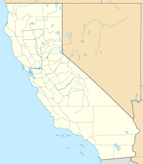
| Location | Shasta County, California |
| Nearest city | Burney, California |
| Area | 910 acres (370 ha) |
| Governing body | California Department of Parks and Recreation |
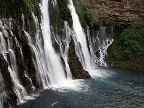
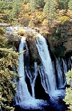
McArthur–Burney Falls Memorial State Park is a beautiful place in California. It's one of the oldest state parks, found about 6 miles (10 km) north of Burney, California. You can go camping, fishing, swimming, hiking, and even horseback riding here. The park is most famous for its amazing waterfall, Burney Falls, right at the entrance. Look out for animals like bass, trout, Steller's jay birds, squirrels, woodpeckers, and deer. Sometimes, you might even spot a black bear!
Contents
Park Geology and Formation
This park is located in a special area where the Cascade Range mountains meet the Modoc Plateau. It has 910 acres (368 hectares) of forest. There are also 5 miles (8 km) of streams and lake shoreline, including part of Lake Britton.
The Amazing Burney Falls
The main attraction is the incredible Burney Falls, which is 129 feet (39 meters) tall. The water for Burney Falls comes from underground springs. More springs join the main creek, creating a misty area around the falls. Below the waterfall, the creek flows into Lake Britton.
Volcanic Landscape
The park's landscape was shaped by volcanic activity and also by erosion from weather and streams. This area is surrounded by mountains and covered in black volcanic rock called basalt. This rock formed over a million years ago. It's like a sponge, holding onto rainwater and melted snow. This creates a huge underground water supply.
Inside the park, this water comes out as springs, especially at Burney Falls. An amazing 100 million gallons (4.4 cubic meters per second) of water flow here every single day!
Park History and Naming
Burney Falls got its name from Samuel Burney, a pioneer who lived in the area in the 1850s. Later, the McArthur Family arrived in the late 1800s. Their descendants were very important because they saved the waterfall and nearby land from being developed. They bought the property and gave it as a gift to the state in the 1920s. This is why the park is called McArthur–Burney Falls Memorial State Park.
Burney Creek Activities
Burney Creek is a smaller stream that flows into the Pit River. Its mouth is on the Lake Britton reservoir to the north. This creek is the only place in the park where you are allowed to go fishing.
If you go upstream about ten yards from the falls, the view becomes very blocked by nature. It's hard to tell you are so close to the waterfall from there.
Fun Recreation Activities
There are many ways to enjoy the park, from hiking to boating!
Hiking Trails
You can explore 5 miles (8 km) of hiking trails that wind through the park's evergreen forests. The famous Pacific Crest Trail actually passes through the park. Hikers on this long trail can even use the park store as a mailing address for supplies! There's also a longer hike to the Pioneer's Cemetery, which is about 3 miles (5 km) long.
Three main trails start near the visitor's center:
- The Falls Loop Trail
- The Burney Creek Trail
- The Headwaters Loop Trail
Falls Loop Trail
The main path is the Falls Loop Trail, which is about 3/4 mile (1.2 km) long. It starts at the Burney Falls overlook, giving you a great view. From there, it goes down to the bottom of the falls. Then, it continues downstream to the Rainbow Footbridge. You cross Burney Creek there and walk up the other side of the ravine. This gives you different views of the falls. Finally, you cross the creek again using Fisherman’s Bridge to return.
Burney Creek Trail
The Burney Creek Trail is 1 mile (1.6 km) long. It starts from the Falls Loop Trail at Rainbow Bridge. This trail leads downstream to Lake Britton and the swimming/boating area. You'll walk through beautiful mixed coniferous forest and see patches of white diatomaceous earth.
Headwaters Loop Trail
The Headwaters Trail is a 1 mile (1.6 km) loop. It starts from the Fisherman’s Bridge parking lot and goes upstream to the headwaters spring. This spring is where the water feeding Burney Falls comes from. The loop comes back downstream, crossing the Pacific Crest Trail Footbridge, and then Fisherman’s Bridge to return to the parking lot.
Lake Britton Fun
A part of Lake Britton is open to all park visitors. This section is owned by PG&E. You can go swimming, boating, and enjoy other water sports. A small area is set aside just for fishing. The water flowing into Lake Britton from Burney Creek is quite cold, staying at about 42 degrees Fahrenheit (6 degrees Celsius).
Boaters can explore the 9-mile (14 km) long lake. There are many hidden spots beyond the park's borders. These include a rail bridge used in the 1986 movie Stand By Me. You can also see the Pit River Dam and many private boat docks. Canoes, kayaks, paddle boats, and even motorized patio boats are available to rent.
Interesting Facts
- The railroad bridge scene from the 1986 movie Stand By Me was filmed just outside the park. It's a bridge owned by the McCloud River Railroad over Lake Britton.
- Only half of Burney Falls was shown in the 1988 George Lucas/Ron Howard movie Willow. The other half was removed using special effects!
- President Theodore Roosevelt once called the falls "the Eighth Wonder of the World."
- The area behind the falls is one of the few known places where the black swift bird builds its nests.
- Burney Falls was recognized as a National Natural Landmark in December 1984.
 | William M. Jackson |
 | Juan E. Gilbert |
 | Neil deGrasse Tyson |


