Meall Tàirneachan facts for kids
Quick facts for kids Meall Tairneachan |
|
|---|---|

Meall Tairneachan
|
|
| Highest point | |
| Elevation | 787 m (2,582 ft) |
| Prominence | 420 m (1,380 ft) |
| Listing | Corbett, Marilyn |
| Geography | |
| Location | Perthshire, Scotland |
| Parent range | Grampian Mountains |
| OS grid | NN807543 |
| Topo map | OS Landranger 52 |
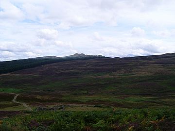
Meall Tairneachan is a mountain located in Scotland. It stands tall at 787 meters (about 2,582 feet). This impressive peak is part of the Grampian Mountains. It is found northwest of a town called Aberfeldy in an area known as Perthshire.
Contents
What is Meall Tairneachan?
Meall Tairneachan is a mountain that offers great views. Its name is Scottish Gaelic. It means "hill of thunder" or "hill of the thunderbolt." This name might come from how the mountain looks during a storm. Or perhaps it's because of the sounds of thunder heard there.
Where is Meall Tairneachan Located?
This mountain is in the heart of Scotland. It sits between two important places. These are Loch Tay, a beautiful lake, and the town of Aberfeldy. The area around Meall Tairneachan is known for its wild beauty. It has many rocky hills and open moorland.
Exploring the Area: Moors and Minerals
The land around Meall Tairneachan is quite rugged. It is covered in what are called "moors." These are open, uncultivated areas. They often have heather and tough grasses. They are home to various types of wildlife. The landscape is rocky and has gentle rolling hills.
What is Baryte?
Close to the top of Meall Tairneachan, there is a special mine. This mine extracts a mineral called baryte. Baryte is a heavy mineral. It is often white or colorless. It is used in many different industries. For example, it is used in oil and gas drilling. It also helps make paint and paper. Finding a mine near a mountain summit is quite interesting.
Mountain Classifications: Corbett and Marilyn
Meall Tairneachan is special because it belongs to two mountain lists. It is a Corbett and a Marilyn.
- A Corbett is a mountain in Scotland. It must be between 2,500 and 3,000 feet (762 and 914.4 meters) high. It also needs a "prominence" of at least 500 feet (152.4 meters). Prominence means how much a mountain rises above the land around it.
- A Marilyn is a hill or mountain of any height. The only rule is that it must have a prominence of at least 150 meters (about 492 feet). This means it stands out clearly from the surrounding land. Being both a Corbett and a Marilyn makes Meall Tairneachan a notable peak for climbers.
 | John T. Biggers |
 | Thomas Blackshear |
 | Mark Bradford |
 | Beverly Buchanan |

