Mena Creek, Queensland facts for kids
Quick facts for kids Mena CreekQueensland |
|||||||||||||||
|---|---|---|---|---|---|---|---|---|---|---|---|---|---|---|---|

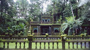
Paronella Park, 2004
|
|||||||||||||||
| Population | 210 (2021 census) | ||||||||||||||
| • Density | 8.57/km2 (22.2/sq mi) | ||||||||||||||
| Postcode(s) | 4871 | ||||||||||||||
| Area | 24.5 km2 (9.5 sq mi) | ||||||||||||||
| Time zone | AEST (UTC+10:00) | ||||||||||||||
| Location |
|
||||||||||||||
| LGA(s) | Cassowary Coast Region | ||||||||||||||
| State electorate(s) | Hill | ||||||||||||||
| Federal Division(s) | Kennedy | ||||||||||||||
|
|||||||||||||||
Mena Creek is a small rural area in Queensland, Australia. It's part of the Cassowary Coast Region. In 2021, about 210 people lived in Mena Creek. It's known for its beautiful natural surroundings and a famous park called Paronella Park.
Contents
History of Mena Creek
Around the year 1900, a man named H. A. Noone was looking for good timber for his sawmills. He found a great spot near a creek, about 12 miles from a town called Geraldton (now Innisfail). This area, originally called Stewarts Creek, had lots of red cedar trees. It also looked perfect for growing sugar cane.
Noone knew it would be hard to get government approval for just one piece of land. So, he gathered a group of 40 people. Each person applied for a 160-acre block of land. The government was impressed and quickly approved the plan. Soon, many farms were cleared, and H. A. Noone started planning where to process the sugar cane.
How Mena Creek Got Its Name
The area's name, Mena Creek, comes from the nearby creek. There are two main ideas about where the creek's name came from:
- One idea is that it was named after Philomena "Mena" Fallon. She was the youngest daughter of H. A. Noone, who was a very early settler in the area. He helped many people move there and even built the first hotel. The name changed from Stewarts Creek to Mena Creek to avoid confusion with another Stewarts Creek near Townsville.
- Another idea is that it was named after "Mena" Camp in Cairo, Egypt. This was a training camp for Australian soldiers (the First Australian Imperial Force) from 1914 to 1915. They trained there before the famous ANZAC landing at Gallipoli.
Mena Creek State School opened its doors on March 15, 1920. Later, the Mena Creek Post Office started operating on February 10, 1934.
Population of Mena Creek
The number of people living in Mena Creek has changed a little over the years.
- In 2016, there were 244 people living in Mena Creek.
- By 2021, the population was 210 people.
Special Places in Mena Creek
Mena Creek has some important historical sites. These are places that are protected because they are special and tell us about the past.
- One very famous place is Paronella Park, located on Mena Creek-Jappoon Road. It's a beautiful old castle-like structure and gardens built by José Paronella.
Education in Mena Creek
Mena Creek State School is a primary school for students from Prep (the first year of school) to Year 6. It's a government school for both boys and girls. In 2018, the school had 38 students and 3 teachers.
There isn't a high school in Mena Creek itself. Students who want to go to secondary school usually travel to Innisfail State College in Innisfail Estate, which is to the north-east.
 | Valerie Thomas |
 | Frederick McKinley Jones |
 | George Edward Alcorn Jr. |
 | Thomas Mensah |


