
Menindee, New South Wales facts for kids
Quick facts for kids MenindeeNew South Wales |
|||||||||
|---|---|---|---|---|---|---|---|---|---|

Ah Chung's Bakehouse Gallery
|
|||||||||

Menindee
Location in New South Wales
|
|||||||||
| Population | 537 (2021 census) | ||||||||
| Postcode(s) | 2879 | ||||||||
| Elevation | 61.0 m (200 ft) | ||||||||
| Location |
|
||||||||
| LGA(s) | Central Darling Shire | ||||||||
| State electorate(s) | Barwon | ||||||||
| Federal Division(s) | Parkes | ||||||||
|
|||||||||
Menindee is a small town in the far west of New South Wales, Australia. It sits on the banks of the Darling River. The town's name comes from the Barkindji word "minandichi". This word refers to the shallow lake near the town.
Menindee was the very first town built along the Darling River. In 2021, about 537 people lived there.
Contents
- A Look Back: Menindee's History
- Special Places: Heritage Listings
- Who Lives Here: Population
- Learning in Menindee: Schools
- Menindee's Landscape: Geography
- Plants and Animals: Natural Environment
- Water in Menindee: Water Supply
- Menindee's Weather: Climate
- Getting Around: Transport
- Images for kids
- See also
A Look Back: Menindee's History
First People of Menindee
The land around Menindee has been home to the Barkindji people for thousands of years. They lived here long before Europeans arrived. There is proof that Aboriginal activities happened here as far back as 35,000 years ago.
As the Willandra Lakes system began to dry up after the last ice age, about 20,000 years ago, more Aboriginal people gathered along the Darling River. The area near Menindee was a great place to live. It had many lakes and channels that overflowed, along with the river.
Early European Explorers
The first Europeans to visit this area were led by Major Thomas Mitchell in 1835. They were exploring the Bogan and Darling rivers. Mitchell's group faced some challenges from Aboriginal groups. Near the Menindee Lakes, they decided it was too risky to continue. Mitchell named the lakes 'Laidley's Chain of Ponds'. The Barkindji people called these lakes 'wontanella', meaning "many waters".
Another explorer, Charles Sturt, arrived at Laidley’s Ponds in October 1844. His team set up a base camp at Lake Cawndilla. For two months, they explored the nearby Barrier Range. Sturt's group then moved further north. They explored the dry inland areas before returning in 1846.
European Settlement Begins

In 1849, Alexander McCallum started a farming area called 'Menindee'. By 1852, Thomas Pain and his family settled in Menindee. They built a hotel to help travelers along the Darling River.
In 1859, Captain Francis Cadell sailed the Albury steamer up the Darling River. He reached Menindee and showed that the river could be used for trade. In 1860, Thomas Pain began delivering mail on horseback along the Darling River.
The famous Burke and Wills expedition also camped in Menindee. They arrived on October 14, 1860, while trying to cross Australia. They set up Camp XXXIV (their 34th camp) here. Some disagreements happened within the group. The leader, Robert O'Hara Burke, split the team. He went north with some men and supplies. The rest stayed at a depot camp at Pamamaroo Creek. Burke stayed at Thomas Pain's hotel during his time in Menindee.
By October 1861, Menindee had a hotel, a store, and a police hut. About fifteen people lived there permanently.
Special Places: Heritage Listings
Menindee has some important historical sites. One is the Kinchega Woolshed, about 15 km south-west of town.
Who Lives Here: Population
According to the 2016 census, 551 people lived in Menindee.
- About 36.1% of the people were Aboriginal and Torres Strait Islander.
- Most people (79.3%) were born in Australia.
- English was the main language spoken at home by 84.3% of people.
Learning in Menindee: Schools
Menindee has the Menindee Central School. It teaches students from kindergarten all the way to Year 12.
Menindee's Landscape: Geography
The town of Menindee sits on a sandhill. It is above the flat land next to the Darling River. The area has red sand dunes and plains. The flat land has grey clay soil. This soil supports woodlands with black box trees.
The Kinchega National Park is right next to the western edge of town.
Plants and Animals: Natural Environment
Menindee Nightshade Plant
The Menindee nightshade (Solanum karsense) is a special plant. It is named after the Menindee region. This plant is grey-green and has soft hairs and spines on its stems. It grows purple flowers in spring.
The Menindee nightshade is found only in the far south-western plains of NSW. It grows between the Darling and Lachlan rivers. It is also found along the Darling River between Menindee and Wilcannia. You can find it in Kinchega National Park near Menindee.
Water in Menindee: Water Supply
A weir (a small dam) on the Darling River near Menindee helps control water flow. It sends water from the river into a series of shallow lakes. These are called the Menindee Lakes. They help manage the river's flow for farming downstream.
People in Menindee have sometimes complained about the water quality. They said it was "putrid" (smelly and bad). Some locals believed cotton farms were taking too much water during dry times. The health of the river depends on summer rains. Sometimes, locals had to get water from other places.
The river can get blooms of blue-green algae in summer. Experts say the Menindee Lakes have been drained more often than in the past. In 2018, environmental water was sent to the Darling River. This helped connect parts of the river and clear out algae.
In early 2019, many native fish died in the river near Menindee. Up to one million fish died, including large Murray cod. This happened because the temperature dropped suddenly. This caused a lot of algae to break down. The oxygen levels in the river then became too low for the fish to live.
Good rainfall in early 2020 helped the Menindee Lakes. Over 550 gigalitres of water flowed into them. More waterbirds have been seen in the area since then. The area also flooded again in early 2023.
Menindee's Weather: Climate
Menindee has a hot desert climate. This means it has hot, dry summers and short, cool winters. The average rainfall is about 284.6 mm (11.2 inches) per year. This makes it a desert climate because of how much water evaporates.
Rainfall can change a lot each year. The town can go months without rain. But sometimes, heavy rainstorms can bring over 100 mm (4 inches) in one day. This last happened in January 2011.
Menindee holds the record for the highest temperature in New South Wales. It reached 49.7 °C (121.5 °F) on January 10, 1939. This temperature is shared with Bourke.
| Climate data for Menindee (1876–2012) | |||||||||||||
|---|---|---|---|---|---|---|---|---|---|---|---|---|---|
| Month | Jan | Feb | Mar | Apr | May | Jun | Jul | Aug | Sep | Oct | Nov | Dec | Year |
| Record high °C (°F) | 49.7 (121.5) |
47.2 (117.0) |
43.4 (110.1) |
41.7 (107.1) |
33.3 (91.9) |
28.9 (84.0) |
28.9 (84.0) |
32.3 (90.1) |
39.5 (103.1) |
42.8 (109.0) |
46.4 (115.5) |
48.9 (120.0) |
49.7 (121.5) |
| Mean daily maximum °C (°F) | 34.4 (93.9) |
33.8 (92.8) |
30.7 (87.3) |
25.6 (78.1) |
20.7 (69.3) |
17.3 (63.1) |
17.0 (62.6) |
19.3 (66.7) |
22.9 (73.2) |
26.5 (79.7) |
30.0 (86.0) |
32.8 (91.0) |
25.9 (78.6) |
| Mean daily minimum °C (°F) | 18.5 (65.3) |
18.2 (64.8) |
15.2 (59.4) |
10.9 (51.6) |
7.5 (45.5) |
5.0 (41.0) |
4.1 (39.4) |
5.3 (41.5) |
8.0 (46.4) |
11.3 (52.3) |
14.6 (58.3) |
16.8 (62.2) |
11.3 (52.3) |
| Record low °C (°F) | 7.0 (44.6) |
6.4 (43.5) |
3.9 (39.0) |
2.0 (35.6) |
−1.6 (29.1) |
−2.8 (27.0) |
−3.5 (25.7) |
−2.0 (28.4) |
0.2 (32.4) |
1.0 (33.8) |
1.7 (35.1) |
6.0 (42.8) |
−3.5 (25.7) |
| Average rainfall mm (inches) | 24.0 (0.94) |
21.7 (0.85) |
18.8 (0.74) |
16.8 (0.66) |
22.7 (0.89) |
21.4 (0.84) |
18.3 (0.72) |
17.9 (0.70) |
18.4 (0.72) |
22.8 (0.90) |
21.2 (0.83) |
21.8 (0.86) |
245.8 (9.65) |
| Average precipitation days | 2.5 | 2.6 | 2.5 | 2.8 | 4.1 | 4.8 | 5.0 | 4.9 | 3.9 | 3.9 | 3.3 | 2.8 | 43.1 |
| Source: Bureau of Meteorology | |||||||||||||
Getting Around: Transport
The transcontinental railway line crosses the Darling River at Menindee. This railway line is about 900 km (560 mi) west of Sydney. It is also about 110 km (68 mi) south-east of Broken Hill.
Menindee has a train service called the Outback Xplorer. It runs between Sydney and Broken Hill. One train goes west to Broken Hill on Mondays. Another train goes east on Tuesdays.
A community bus service also runs to Broken Hill. It operates Monday to Friday, except on public holidays. No major highway goes directly through Menindee. However, the Barrier Highway runs nearby to the north, through Broken Hill.
Images for kids
-
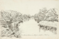
'Junction of the Paramaru Creek with the River Darling' by Hermann Beckler (1861)
See also
 In Spanish: Menindee para niños
