Merced Peak facts for kids
Quick facts for kids Merced Peak |
|
|---|---|
| Highest point | |
| Elevation | 11,731 ft (3,576 m) NAVD 88 |
| Prominence | 1,206 ft (368 m) |
| Listing | Sierra Peaks Section |
| Geography | |
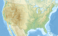
| Location | Madera County, California, U.S. |
| Parent range | Clark Range |
| Topo map | USGS Merced Peak |
| Climbing | |
| Easiest route | Scramble, class 2 |
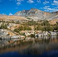
Merced Peak is a very tall mountain located in California, United States. It stands at an impressive 11,731 feet (about 3,576 meters) above sea level. This makes it the highest point in the Clark Range. It is taller than other nearby mountains like Red Peak, Gray Peak, and Mount Clark.
Where is Merced Peak?
Merced Peak is found in the beautiful Sierra Nevada mountain range. It is very close to the southern border of Yosemite National Park. You can find it near a group of pretty lakes known as the Ottoway Lakes.
If you wanted to visit the summit, there are a few ways to get there. One path starts from the Quartz Mountain Trailhead. Another way is from one of the trails found on the road that leads to Glacier Point.
John Muir's Important Discovery
In 1871, a famous Scottish-American naturalist named John Muir made an exciting discovery. He found an active alpine glacier right below Merced Peak. A glacier is a huge, slow-moving river of ice.
This discovery was very important. It helped John Muir prove his idea that the famous Yosemite Valley was shaped by glaciers. Before this, many people thought the valley was formed by earthquakes. Muir's finding of an active glacier helped show that ice played a big role in creating Yosemite's amazing landscapes.
Images for kids
See also
 In Spanish: Merced Peak para niños
 | Bessie Coleman |
 | Spann Watson |
 | Jill E. Brown |
 | Sherman W. White |


