Middleport, New York facts for kids
Quick facts for kids
Middleport
|
|
|---|---|
| Village of Middleport | |

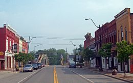
View north along Main Street towards canal
|
|
| Nickname(s):
Tea-Pot Hollow
|
|
| Motto(s):
A Friendly Community
|
|

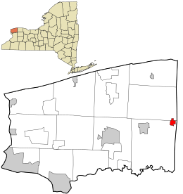
Location in Niagara County and the state of New York.
|
|
| Country | United States |
| State | New York |
| County | Niagara |
| Towns | Hartland, Royalton |
| Area | |
| • Total | 0.87 sq mi (2.26 km2) |
| • Land | 0.87 sq mi (2.26 km2) |
| • Water | 0.00 sq mi (0.00 km2) |
| Elevation | 515 ft (157 m) |
| Population
(2020)
|
|
| • Total | 1,729 |
| • Density | 1,982.80/sq mi (765.70/km2) |
| Time zone | UTC-5 (Eastern (EST)) |
| • Summer (DST) | UTC-4 (EDT) |
| ZIP code |
14105
|
| Area code(s) | 716 |
| FIPS code | 36-46998 |
| GNIS feature ID | 0957150 |
| Website | Village of Middleport |
Middleport is a small village located in Niagara County, New York, in the United States. In 2010, about 1,840 people lived there. The village has a special mail code, 14105.
Middleport is part of the larger Buffalo–Niagara Falls area. It sits on the eastern edge of Niagara County. Most of Middleport is within the Town of Royalton. A small part is also in the Town of Hartland. Middleport is an important stop on the famous Erie Canal.
Contents
Village History
People started settling in the Middleport area around 1808. The first store opened in what would become the village in 1822. This was even before the canal reached the community.
The Erie Canal's Impact
The Erie Canal fully opened in 1825. This made Middleport a very important place along the canal. Goods and people could travel easily through the village.
How Middleport Got Its Name
Before it was called Middleport, the village had a fun nickname: Tea-Pot Hollow. It was later renamed Middleport.
Becoming an Official Village
The Village of Middleport officially became a village in 1872. The first election for village leaders happened earlier, on March 22, 1859. The first meeting of the village's Board of Trustees was held on March 28, 1859.
Historic Buildings in Middleport
Two buildings in Middleport are listed on the National Register of Historic Places. These are the William Taylor House and the U.S. Post Office. These places are important parts of the village's history.
Geography of Middleport
Middleport covers an area of about 0.9 square miles (2.26 square kilometers). All of this area is land.
Main Roads and Location
The village is located where several important roads meet. New York State Route 271, also known as Main Street, runs north and south. It crosses paths with east-west highways like New York State Route 31 (Telegraph Road) and New York State Route 31E (State Street).
Population Changes
| Historical population | |||
|---|---|---|---|
| Census | Pop. | %± | |
| 1870 | 731 | — | |
| 1880 | 771 | 5.5% | |
| 1890 | 1,217 | 57.8% | |
| 1900 | 1,431 | 17.6% | |
| 1910 | 1,530 | 6.9% | |
| 1920 | 1,416 | −7.5% | |
| 1930 | 1,596 | 12.7% | |
| 1940 | 1,575 | −1.3% | |
| 1950 | 1,641 | 4.2% | |
| 1960 | 1,882 | 14.7% | |
| 1970 | 2,132 | 13.3% | |
| 1980 | 1,995 | −6.4% | |
| 1990 | 1,876 | −6.0% | |
| 2000 | 1,917 | 2.2% | |
| 2010 | 1,840 | −4.0% | |
| 2020 | 1,729 | −6.0% | |
| U.S. Decennial Census | |||
The population of Middleport has changed over the years. In 2000, there were 1,917 people living in the village. By 2010, the population was 1,840. The most recent count in 2020 showed 1,729 people.
Population Density
In 2000, the village had about 2,196 people per square mile (848 people per square kilometer). This tells us how many people live in a certain amount of space.
Age Groups
The population of Middleport includes people of all ages. In 2000, about 28.7% of the people were under 18 years old. About 14.9% were 65 years or older. The average age in the village was 36 years.
See also
 In Spanish: Middleport (Nueva York) para niños
 | Delilah Pierce |
 | Gordon Parks |
 | Augusta Savage |
 | Charles Ethan Porter |

