
Middleton Dale facts for kids
Quick facts for kids Middleton Dale |
|
|---|---|
| Stoney Middleton Dale | |

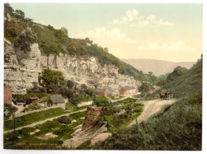
Crags by A623 in Middleton Dale
|
|
| Length | 1.9 miles (3 km) West-East |
| Width | 250 metres (820 ft) |
| Depth | 60 metres (197 ft) |
| Geography | |
| Location | Derbyshire, England |
| Rivers | Dale Brook |
Middleton Dale is a beautiful valley in the Derbyshire Peak District of England. It has very steep sides made of a type of rock called carboniferous limestone. This rock formed from ancient sea creatures and plants.
The village of Stoney Middleton is at the eastern end of the valley. The village of Eyam is about 600 metres (660 yd) north, connected by a smaller valley called Eyam Dale. Middleton Dale is carved into the higher lands of Middleton Moor and Eyam Moor. A stream called Dale Brook flows through the valley. It eventually joins the River Derwent. The Delf is a hidden, wooded side gorge with its own stream.
Contents
Exploring Middleton Dale's Caves
The northern side of Middleton Dale has many caves and sinkholes. Sinkholes are places where water disappears underground. Most of these caves are narrow and can be muddy. There are around 70 entrances and over 3 kilometres (1.9 mi) of cave passages.
Famous Caves in Middleton Dale
- Carlswark Cavern: This large cave system was first written about in 1734. It goes all the way through the mountain to Eyam Dale. Inside, you can find a big room called Oyster Chamber. It's named for the many fossilized shells found there.
- Merlin Cavern: This cave has 1 kilometre (0.62 mi) of passages. Many of these passages were created by old lead miners.
- Fingals Cave: This cave has the largest entrance in the valley. It was also an old mine.
For hundreds of years, people have taken limestone from Middleton Dale. This limestone is full of fossils. It formed about 330 million years ago from deposits in a warm, shallow sea.
Rock Climbing Adventures

Middleton Dale is a very popular place for rock climbing. It has over 450 climbing routes. These routes are on large rock faces that are up to 50 metres (160 ft) high. Some routes, like Alcasan and Our Father, are famous across the country. It's also a great spot for bouldering, which is climbing on smaller rocks without ropes.
The Legend of Lovers Leap
Lovers Leap is a tall cliff near the start of the valley. In 1762, a young woman named Hannah Baddeley was very sad. She threw herself from the cliff. But she survived! The story says her long skirt acted like a parachute. It then got caught in bushes, stopping her fall. She didn't get badly hurt, but she passed away two years later. The old stone building at the bottom of the cliff is now a restaurant. It is called Lovers Leap, after the legend.
Nature and Wildlife in Middleton Dale
Middleton Dale is a special place for nature. It is a designated Site of Special Scientific Interest (SSSI). This means it's protected because of its important plants, animals, or geology.
Plants and Trees of the Valley
The lower slopes of the valley have ancient woodlands. You can find ash trees, wych elm, and hazel. On the higher limestone cliffs, there are rock whitebeam, yew, and field maple.
Wildflowers and Shrubs
The limestone cliffs also support many rare native grasses. You can see a variety of shrubs and wildflowers, including:
- Dogwood
- Buckthorn
- Common rock-rose
- Dog rose
- Cowslip
- Moschatel
- Wood avens
- Bluebell
- Early dog-violet
- Ramson
- Golden saxifrage
- Mossy saxifrage
Getting Around Middleton Dale
The A623 road runs through the entire valley. This road was built in the 1700s. You can find footpaths into the valley from Eyam. However, there are no footpaths along the valley floor itself. This is because the road takes up all the space.
