Milecastle 48 facts for kids
Quick facts for kids Milecastle 48 |
|
|---|---|
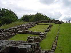
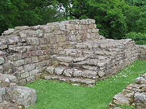
The remains of Milecastle 48, showing
that it was built on a steep slope |
|
| Type | Milecastle |
| Place in the Roman world | |
| Province | Britannia |
| Structure | |
| — Stone structure — | |
| Size and area | 18.5 m × 21.3 m (0.04 ha) |
| Location | |
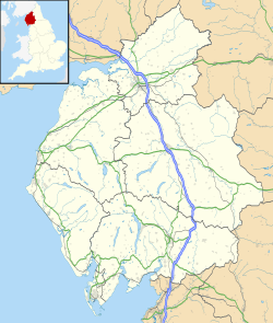
| Coordinates | 54°59′20″N 2°34′24″W / 54.988991°N 2.573425°W |
| County | Cumbria |
| Country | England |
Milecastle 48 (Poltross Burn) is a cool ancient Roman fort on Hadrian's Wall. You can find its remains near the village of Gilsland in Cumbria, England. For a long time, people called it "The King's Stables." This was because its inside walls were so well-preserved. What's really special is that a big part of its stone stairs is still there! Two smaller watchtowers, called turrets, that belonged to this milecastle can also still be seen.
Contents
Discovering Milecastle 48
Milecastle 48 is located right outside the village of Gilsland in Cumbria. It sits next to the Tyne Valley railway line. People in the area knew it as "The King's Stables" for over 100 years. Now, it is often called Poltross Burn Milecastle. This is how it is signposted today. The site is looked after by English Heritage, a group that protects historic places.
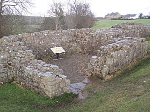
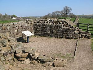
This milecastle is quite large compared to others. It measures about 18.5 meters (60 feet) from east to west. It is 21.3 meters (70 feet) from north to south. Inside, you can still see the outlines of two rows of buildings. These were probably barracks, where soldiers lived. One row was on each side of the main road that went through the milecastle's gates.
Usually, the buildings inside milecastles are not this well-preserved. Local people who used to take stones from the site might have thought the layout looked like stable-blocks. This is why they called it "The King's Stables." The walls of Milecastle 48 are "broad gauge." This means they were built to match the wider parts of Hadrian's Wall. It also has "wing walls" that connect to the "Narrow Wall" sections of Hadrian's Wall.
Milecastle 48 has a special type of gate called "Type III gateways." It is located about 1521 meters (almost a mile) west of Milecastle 47. It is also about 1458 meters (just under a mile) east of Milecastle 49.
What the Stairs Tell Us
A really cool part of this milecastle is the stone staircase. A large section of it is still standing in the northeast corner. This staircase would have led up to the top of Hadrian's Wall. By looking at these stairs, experts could figure out how tall the wall-walk was. They believe the walkway was about 3.6 meters (12 feet) high. This also suggests the entire wall, including its protective top part, was around 4.6 meters (15 feet) tall.
Before Hadrian's Wall was built, there was another Roman road called the Stanegate. This road crossed the Poltross Burn a few hundred yards south of Milecastle 48. You can still see parts of its route going down a field to the river. There was also a small Stanegate fort called Throp nearby. It was on top of the ridge southwest of Milecastle 48, but you can't see its remains on the ground today.
Exploring the Past: Excavations
Archaeologists have dug at Milecastle 48 several times. These digs help us learn more about its history.
- In 1886, R. S. Ferguson led the first excavation.
- Between 1909 and 1911, J. P. Gibson and F. G. Simpson continued the work.
- Later, from 1965 to 1966, D. Charlesworth carried out more excavations.
These excavations uncovered many interesting things. They found the milecastle's gateways. They also discovered the lower parts of the flight of steps in the northeast corner. An oven was found in the northwest part of the milecastle. The long barrack blocks, where soldiers lived, were also found. It seems these buildings were rebuilt or changed more than once over time.
Meet the Associated Turrets
Every milecastle along Hadrian's Wall had two smaller watchtowers, called turrets. These turrets were placed about one-third and two-thirds of a Roman mile to the west of the milecastle. Soldiers from the milecastle would have likely guarded these turrets. The two turrets connected to Milecastle 48 are known as Turret 48A and Turret 48B.
Turret 48A: Willowford East
Turret 48A (Willowford East) is located on a flat area of land next to the River Irthing. It was excavated in 1923. This turret is about 4.1 meters (13.5 feet) wide. Its north wall is still 1.3 meters (4 feet) high in some places. The east wall has seven layers of stones, the west wall has five, and the south wall has six. The entrance was in the southwest wall. Inside, archaeologists found several hearths (fireplaces) and signs that people worked with bronze and iron there. The site was cleaned up and partly rebuilt in 1951-1952. Today, you can see its remains as solid stone walls.
Turret 48B: Willowford West
Turret 48B (Willowford West) is also on the south bank of the River Irthing. It is just east of Willowford Farm. This turret was also excavated in 1923. Like Turret 48A, its remains are visible today as strong, preserved stone walls.
 | Toni Morrison |
 | Barack Obama |
 | Martin Luther King Jr. |
 | Ralph Bunche |


