Milefortlet 5 facts for kids
Quick facts for kids Milefortlet 5 |
|
|---|---|

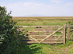
View over the Solway marshes, north of the site of Milefortlet 5
|
|
| Type | Milecastle |
| Place in the Roman world | |
| Province | Britannia |
| Location | |
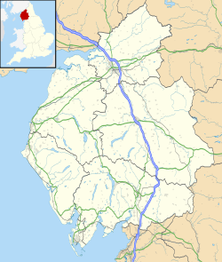
| Coordinates | 54°54′48″N 3°17′44″W / 54.913343°N 3.29555°W |
| County | Cumbria |
| Country | England |
Milefortlet 5 (Cardurnock) was a small Roman fortlet located on the Cumbrian coast. This area was part of the Roman defenses in Roman Britain. These defenses included milefortlets and stone watchtowers. They stretched from the western end of Hadrian's Wall along the coast of Cumbria. A wooden fence, called a palisade, connected these structures. They were built around the same time as Hadrian's Wall. Archaeologists dug up the remains of Milefortlet 5 in 1943-1944. This happened just before the site was destroyed in 1944.
What Was Milefortlet 5?
Milefortlet 5 was found in a field near a small village called Cardurnock. This area is in the civil parish of Bowness. Today, the site is a grassy field that used to be a wartime airfield. You cannot see anything on the ground now. However, special pictures taken from the air in 2006 show "cropmarks." These are patterns in crops or grass that show where old structures used to be buried. The cropmarks show the northern part of the fortlet.
South of this site, the coastline is broken by Moricambe Bay. The next known fortlet is Milefortlet 9. People once thought that Milefortlets 6, 7, and 8 were washed away by Moricambe Bay. But there is no proof that these sites ever existed. So, the defense system seems to start again with Milefortlet 9.
Uncovering the Past: Excavations
Archaeologists dug up Milefortlet 5 in 1943 and 1944. This was done before an airfield was built there. The digs showed that the fortlet was built in three main stages.
The first stage was built during the time of Emperor Hadrian. The second stage was during the time of Emperor Antoninus Pius. In this period, the fortlet was made smaller. The third stage seems to be from the 4th century. During this last stage, the fortlet's outer walls, called ramparts, were kept. But they were rebuilt on the south, west, and north sides. It also looks like a stone building was added inside the fortlet during this time.
A Roman road was also found southwest of Milefortlet 5. This road was excavated by archaeologists in 1992 and 1993.
Watchtowers and Coastal Defenses
Each milefortlet had two watchtowers connected to it. These towers were built in a similar way to the turrets found along Hadrian's Wall. They were placed about one-third and two-thirds of a Roman mile to the west of the milefortlet. A Roman mile was a bit shorter than a modern mile.
However, the coastline here is interrupted by Moricambe Bay. Because of this, any other towers in this specific area are just guesses. There is no solid evidence they were ever built.
 | Stephanie Wilson |
 | Charles Bolden |
 | Ronald McNair |
 | Frederick D. Gregory |


