
Millaroo, Queensland facts for kids
Quick facts for kids MillarooQueensland |
|||||||||||||||
|---|---|---|---|---|---|---|---|---|---|---|---|---|---|---|---|

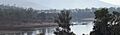
Burdekin River at Millaroo
|
|||||||||||||||

Millaroo
Location in Queensland
|
|||||||||||||||
| Population | 86 (2021 census) | ||||||||||||||
| • Density | 1.490/km2 (3.86/sq mi) | ||||||||||||||
| Postcode(s) | 4807 | ||||||||||||||
| Elevation | 50 m (164 ft) | ||||||||||||||
| Area | 57.7 km2 (22.3 sq mi) | ||||||||||||||
| Time zone | AEST (UTC+10:00) | ||||||||||||||
| Location |
|
||||||||||||||
| LGA(s) | Shire of Burdekin | ||||||||||||||
| State electorate(s) | Burdekin | ||||||||||||||
| Federal Division(s) | Kennedy | ||||||||||||||
|
|||||||||||||||
|
|||||||||||||||
Millaroo is a small town in Queensland, Australia. It is located in the Shire of Burdekin region. In 2021, only 86 people lived there, making it a very quiet place!
Contents
Where is Millaroo?
Millaroo is located in Queensland, Australia. The Burdekin River forms its western border. It is about 100 kilometers (62 miles) south-east of Townsville. The town is also about 50 kilometers (31 miles) inland from the Coral Sea.
This area is known for growing sugarcane. Farmers use underground water to help their crops grow.
Millaroo's Weather
Millaroo has a warm climate. It's called a dry-winter humid subtropical climate. This means it has a short wet season and a long dry season.
- The wet season is from December to March.
- The dry season is from April to October. During this time, nights are cooler and there's more sunshine.
The hottest months are November and December, with temperatures around 33.4°C (92.1°F). July is the coolest month, with temperatures around 25.5°C (77.9°F). The coldest nights are in July, with temperatures around 9.9°C (49.8°F).
Millaroo gets about 843.3 millimeters (33.2 inches) of rain each year. Most of this rain falls during the summer months. The highest temperature ever recorded was 44.4°C (111.9°F) in February 1969. The lowest was -0.7°C (30.7°F) in June 1984.
| Climate data for Millaroo (20º03'00"S, 147º16'12"E, 45 m AMSL) (1965-1993 normals and extremes, rainfall to 1958) | |||||||||||||
|---|---|---|---|---|---|---|---|---|---|---|---|---|---|
| Month | Jan | Feb | Mar | Apr | May | Jun | Jul | Aug | Sep | Oct | Nov | Dec | Year |
| Record high °C (°F) | 42.2 (108.0) |
44.4 (111.9) |
39.7 (103.5) |
36.5 (97.7) |
33.0 (91.4) |
32.2 (90.0) |
31.0 (87.8) |
36.4 (97.5) |
37.5 (99.5) |
38.7 (101.7) |
43.7 (110.7) |
42.0 (107.6) |
44.4 (111.9) |
| Mean daily maximum °C (°F) | 33.1 (91.6) |
32.5 (90.5) |
31.7 (89.1) |
30.2 (86.4) |
27.9 (82.2) |
25.8 (78.4) |
25.5 (77.9) |
27.5 (81.5) |
29.8 (85.6) |
31.8 (89.2) |
33.4 (92.1) |
33.4 (92.1) |
30.2 (86.4) |
| Mean daily minimum °C (°F) | 22.6 (72.7) |
22.4 (72.3) |
20.9 (69.6) |
17.9 (64.2) |
15.0 (59.0) |
11.0 (51.8) |
9.9 (49.8) |
11.6 (52.9) |
13.8 (56.8) |
16.9 (62.4) |
20.3 (68.5) |
21.8 (71.2) |
17.0 (62.6) |
| Record low °C (°F) | 15.7 (60.3) |
17.0 (62.6) |
13.2 (55.8) |
8.3 (46.9) |
3.3 (37.9) |
−0.7 (30.7) |
0.0 (32.0) |
0.5 (32.9) |
4.0 (39.2) |
8.9 (48.0) |
12.7 (54.9) |
14.4 (57.9) |
−0.7 (30.7) |
| Average precipitation mm (inches) | 190.7 (7.51) |
168.8 (6.65) |
128.5 (5.06) |
48.9 (1.93) |
45.9 (1.81) |
20.4 (0.80) |
15.7 (0.62) |
10.4 (0.41) |
8.5 (0.33) |
25.6 (1.01) |
55.0 (2.17) |
127.4 (5.02) |
843.3 (33.20) |
| Average precipitation days (≥ 1.0 mm) | 9.4 | 10.3 | 8.3 | 4.6 | 3.7 | 2.1 | 1.8 | 1.4 | 1.1 | 2.7 | 4.6 | 7.2 | 57.2 |
| Mean monthly sunshine hours | 229.4 | 200.6 | 220.1 | 222.0 | 223.2 | 234.0 | 251.1 | 266.6 | 273.0 | 297.6 | 285.0 | 257.3 | 2,959.9 |
| Percent possible sunshine | 56 | 56 | 58 | 64 | 64 | 71 | 73 | 75 | 76 | 76 | 73 | 62 | 67 |
| Source: Bureau of Meteorology (1965-1993 normals and extremes, rainfall to 1958) | |||||||||||||
Millaroo's Past

The name Millaroo comes from Millaroo Creek. A surveyor named Robert Abbott recorded the creek's name in 1895. No one knows for sure where the name came from. There was also a large farm called Millaroo in the past.
After World War II, some land in the area was given to soldiers returning from the war. They tried to grow tobacco there, but it was not successful.
In 1952, there was a big plan to build a new town. This town, to be called Millaroo, would be a "modern" and "first-class" planned town. It was designed with parks and areas for businesses. The plan was for it to hold up to 6,000 people. Buildings were to be made of brick and concrete to prevent fires.
Also in 1952, the Millaroo Research Station was set up. It was created by the Queensland Department of Agriculture and Stock. Its job was to do research to help farmers in North Queensland.
The Burdekin Gorge Weir was finished in November 1953. This structure on the Burdekin River helps provide water for irrigation. After this, the land in Millaroo started growing sugarcane instead of tobacco.
Millaroo State School opened its doors on July 19, 1954. The Millaroo Post Office opened on July 1, 1955, but it closed in 1972.
Education in Millaroo

Millaroo State School is a government primary school. It teaches children from Early Childhood up to Year 6. The school is located at 1-13 Cunningham Street. In 2018, the school had 9 students and 3 teachers.
There is no high school in Millaroo itself. The closest high school is Home Hill State High School. It is in Home Hill, which is some distance away. Because of the distance, some families might choose other options. These include learning from home or sending their children to boarding schools.
Images for kids
-
Burdekin River at Millaroo
-
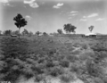
Millaroo Experiment Station buildings being built in November 1955
-
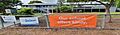
Millaroo State School
