Min Hi Line facts for kids
Quick facts for kids Min Hi Line |
|
|---|---|

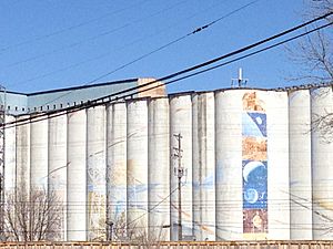
View of murals on a grain elevator in the Min Hi Line corridor.
|
|
| Type | Urban linear park; Shared-use path |
| Location | Minneapolis, Minnesota, United States |
| Created | 2018 |
| Operated by | City of Minneapolis |
| Status | Pilot phase |
| Public transit access | Metro Blue Line; Metro buses |
The Min Hi Line is a cool idea for a new park and pathway in Minneapolis, Minnesota. It's planned to be a linear park, which means it's a long, narrow park. It will also have a shared-use path, a special trail where people can walk, bike, and roll.
This project wants to turn an old railway and industrial area into a fun, green space. It's inspired by famous projects like the Atlanta Beltline and New York High Line. The Min Hi Line would be about 3 miles (4.8 km) long. It would go through neighborhoods with homes, shops, gardens, playgrounds, and even public art! Some small parts of the project were finished in 2018 and 2019. These parts connect the Min Hi Line to other trails nearby.
Contents
History of the Min Hi Line
The area where the Min Hi Line is planned is currently used by several companies. These include Canadian Pacific Railway, Archer Daniels Midland, Leder Brothers Metal, and General Mills.
The old Atkinson Mill building is a very old structure. It's been there for over 100 years. It will be the last active grain mill in Minneapolis once Archer Daniel Midland stops its work there. These big grain silos and mill buildings are a special part of the neighborhood. They might even become part of the new park design. The city has long-term plans to turn these old freight rail tracks into parks and open spaces. A local group called the Min Hi Line Coalition is working hard to share ideas about how to reuse this industrial area.
First Steps: Pilot Projects
To test out the idea, two pilot projects were completed. These small sections show what the Min Hi Line could look like.
Connecting to the Greenway
In 2019, a pathway was built along Hiawatha Avenue. It goes from East 32nd Avenue to East 28th Avenue. This path is technically part of the Hiawatha LRT Trail. But it's also seen as the very northern part of the future Min Hi Line.
Linking to Minnehaha Park
Another pathway was built near East 46th Avenue and Snelling Avenue. This path is part of a new housing and shopping area. It leads to Nawadaha Boulevard. This section is considered the southern end of the Min Hi Line.
The Min Hi Line Route
The name "Min Hi Line" comes from the Minnehaha-Hiawatha freight rail corridor. This corridor runs between Hiawatha Avenue and Snelling Avenue/Dight Avenue.
At its northern end, the Min Hi Line would connect to the Midtown Greenway. At its southern end, it would reach the beautiful Minnehaha Falls area. The pathway would be about 3 miles (4.8 km) long. It would cross 12 streets as it goes from north to south.
People using the trail could easily connect to many other paths. These include the Hiawatha LRT Trail, Little Earth Trail, and the Grand Rounds trail network. The Min Hi Line area has many apartment buildings and businesses.
This park would be different from "bike highways." Bike highways are mostly for fast travel and exercise. The Min Hi Line is designed for more relaxed activities. It would be a place to connect with friends and enjoy nature. It would also add more green spaces to the city.
Places Nearby
The Min Hi Line would be close to many interesting spots.
Fun Attractions
- Hiawatha Avenue Mural: A cool mural on the Harvest States grain elevator by artist Sara Rotholz Weiner.
- Lake Street shopping district: A great place for shopping.
- Minnehaha Mile boutique and vintage shopping district: Unique shops with special items.
- Minnehaha Regional Park: A large park with famous waterfalls.
- Purple Rain house: A historic landmark from the movie "Purple Rain."
Local Neighborhoods
- Longfellow community: Includes the neighborhoods of Cooper, Hiawatha, Howe, and Longfellow.
- West of Hiawatha Avenue: Includes Corcoran, Ericsson, and Standish.
Ways to Get Around
- Metro Blue Line: A light rail train.
- Lake Street/Midtown Station
- 38th Street Station
- 46th Street Station
- Shared-use paths: Trails for walking and biking.
- Grand Rounds
- Hiawatha LRT Trail
- Little Earth Trail
- Midtown Greenway
- Streets: Important roads nearby.
- Hiawatha Avenue
- Lake Street
 | Janet Taylor Pickett |
 | Synthia Saint James |
 | Howardena Pindell |
 | Faith Ringgold |

