
Mitchell River National Park (Western Australia) facts for kids
Quick facts for kids Mitchell River National ParkWestern Australia |
|
|---|---|
|
IUCN Category II (National Park)
|
|
 |
|

Mitchell River National Park
Location in Western Australia
|
|
| Nearest town or city | Wyndham |
| Established | 2000 |
| Area | 1,153.25 km2 (445.3 sq mi) |
| Managing authorities | Department of Parks and Wildlife |
| Website | Mitchell River National Park |
| See also | List of protected areas of Western Australia |
The Mitchell River National Park is a special place in the Kimberley region of Western Australia. It's about 2,140 kilometers (1,330 mi) northeast of Perth. This park is next to the Prince Regent National Park.
The closest towns are Derby, which is 350 kilometers (217 mi) southwest, and Wyndham, 270 kilometers (168 mi) southeast. The park was created in the year 2000. It covers a huge area of over 1,150 square kilometers (444 sq mi). This area is also known as the Mitchell Plateau or Ngauwudu.
Two main attractions in the park are Mitchell Falls, a beautiful waterfall on the Mitchell River, and Surveyors Pool, also called Aunauyu. This land belongs to the Wunambal people, who are Aboriginal Australians.
The park is famous for its unique plants, like a type of fan palm. It's also home to many important and threatened species. These include the tiny rock wallaby called the monjon and the rare black grasswren.
Contents
History of Mitchell River National Park
The animals and plants on the Mitchell Plateau have stayed the same for almost 50,000 years. This shows how special and untouched this area is.
Traditional Owners: The Wunambal People
Ngauwudu is the name the Wunambal people use for the Mitchell Plateau. The Wunambal people have lived here for thousands of years. They follow their traditions based on Wandjina (whom they call Gulingi) and Wunggurr lore. The Wunambal are part of a larger group of Aboriginal peoples called Wanjina Wunggurr.
European Exploration and Park Creation
European explorers first came to this region in 1821. William Easton, a surveyor, led them. He named the Mitchell River after James Mitchell, who was the Premier of Western Australia at the time.
In 1965, a mining company set up a camp on the plateau. The Mitchell River National Park was officially formed in 2000. Today, the park covers more than 1,150 square kilometers (444 sq mi) of the Mitchell Plateau.
Managing the Park and Future Plans
The park is located in the Uunguu (Wunambal Gaambera) area. This is the traditional land of the Wanjina Wunggurr peoples. In 2011, the Wunambal Gaambera people were recognized as the traditional owners of this land. They are represented by the Wunambal Gaambera Aboriginal Corporation.
Working Together for Conservation
The first part of the Uunguu Indigenous Protected Area (IPA) was created in 2011. It covered 343,700 hectares (849,300 acres). A second part was added in 2015. As of 2020, the IPA covers a huge area of 759,806 hectares (1,877,530 acres). The Wunambal Gaambera Aboriginal Corporation works with Bush Heritage Australia. This is a group that helps protect the environment.
The WA Parks and Wildlife Service manages the park together with the Wunambal Gaambera people. This partnership helps protect the land and its culture.
Protecting the Land from Mining
In 2015, the Government of Western Australia made an agreement with mining companies. This agreement stopped mining in an area of 1,750 square kilometers (676 sq mi). The government also started talking with the traditional owners. They wanted to create a huge protected area. This new area would be next to the Great Kimberley Marine Park.
There were plans for a new, very large Kimberley National Park. It would cover more than 20,000 square kilometers (7,722 sq mi). This park would include the Prince Regent National Park and the Lawley River National Park. However, these plans have not moved forward since 2017.
Amazing Animals and Plants
The Mitchell Plateau is very special. It's the only place in mainland Australia where no native animal species have become extinct. This means it's a safe home for many creatures.
Wildlife in the Park
The park is full of life! It has over 50 types of mammals, 220 kinds of birds, and 86 different amphibians and reptiles. Some of these animals include the saltwater crocodile, the king brown snake, and the taipan.
You can find different types of environments here. There are mangroves, swamps, woodlands, and even small areas of tropical rainforest.
Unique Plants
One special plant is a type of Livistona palm. It's called Livistona eastonii and is found only in the north Kimberley. Locals call it darngarna. These palms can grow up to 18 meters (59 ft) tall. Some are as old as 280 years!
Rare and Important Animals
The monjon is a small rock wallaby that lives in the sandstone areas. The rough-scaled python also lives here. Other important animals include the dugong (balguja), the flatback turtle, the northern quoll (wijingarri), the scaly-tailed possum (yilangal), and the golden-backed tree rat.
The park is part of an important bird area. It's called the Prince Regent and Mitchell River Important Bird Area. This is because many bird species live here, especially those that need tropical savanna habitats. The park is home to the black grasswren (dalal), which is a near threatened species. It builds its nests in cracks in the sandstone.
How to Visit Mitchell River National Park
You can reach the Mitchell Plateau track by 4WD vehicle only. It's off the Kalumburu Road, about 172 kilometers (107 mi) north of the Gibb River Road junction. There is also an airstrip if you want to fly in.
Climate in the Park
Mitchell River National Park has a tropical savanna climate. This means it's warm all year round. The wet season is usually from November to March and brings a lot of rain.
| Climate data for Mitchell Plateau | |||||||||||||
|---|---|---|---|---|---|---|---|---|---|---|---|---|---|
| Month | Jan | Feb | Mar | Apr | May | Jun | Jul | Aug | Sep | Oct | Nov | Dec | Year |
| Record high °C (°F) | 40.9 (105.6) |
38.1 (100.6) |
37.3 (99.1) |
40.0 (104.0) |
37.3 (99.1) |
33.5 (92.3) |
34.7 (94.5) |
37.3 (99.1) |
39.4 (102.9) |
40.5 (104.9) |
42.3 (108.1) |
39.7 (103.5) |
42.3 (108.1) |
| Mean daily maximum °C (°F) | 32.5 (90.5) |
32.1 (89.8) |
32.7 (90.9) |
33.2 (91.8) |
31.7 (89.1) |
29.6 (85.3) |
30.1 (86.2) |
32.5 (90.5) |
34.5 (94.1) |
35.7 (96.3) |
36.0 (96.8) |
34.5 (94.1) |
32.9 (91.3) |
| Daily mean °C (°F) | 27.6 (81.7) |
27.3 (81.1) |
27.3 (81.1) |
25.9 (78.6) |
23.2 (73.8) |
20.4 (68.7) |
19.9 (67.8) |
22.6 (72.7) |
25.4 (77.7) |
27.8 (82.0) |
29.2 (84.6) |
28.7 (83.7) |
25.4 (77.8) |
| Mean daily minimum °C (°F) | 22.8 (73.0) |
22.6 (72.7) |
21.9 (71.4) |
18.6 (65.5) |
14.8 (58.6) |
11.2 (52.2) |
9.7 (49.5) |
12.7 (54.9) |
16.4 (61.5) |
20.0 (68.0) |
22.4 (72.3) |
23.0 (73.4) |
18.0 (64.4) |
| Record low °C (°F) | 17.9 (64.2) |
18.4 (65.1) |
16.5 (61.7) |
9.4 (48.9) |
5.2 (41.4) |
1.5 (34.7) |
1.7 (35.1) |
4.2 (39.6) |
7.5 (45.5) |
9.0 (48.2) |
15.6 (60.1) |
18.2 (64.8) |
1.5 (34.7) |
| Average rainfall mm (inches) | 378.6 (14.91) |
367.5 (14.47) |
320.4 (12.61) |
41.0 (1.61) |
31.5 (1.24) |
8.4 (0.33) |
16.4 (0.65) |
1.3 (0.05) |
11.8 (0.46) |
52.0 (2.05) |
126.9 (5.00) |
182.1 (7.17) |
1,537.9 (60.55) |
| Average rainy days | 19.6 | 19.6 | 17.8 | 5.4 | 2.2 | 0.7 | 0.6 | 0.3 | 1.7 | 4.7 | 10.3 | 13.9 | 96.8 |
Images for kids
-
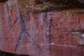
Rock art in Mitchell River National Park

