Mogollon-Datil volcanic field facts for kids
Quick facts for kids Mogollon-Datil volcanic field |
|
|---|---|
| Highest point | |
| Geography | |
| Location | New Mexico, United States |
| Geology | |
| Age of rock | Middle Tertiary |
| Mountain type | Volcanic field |
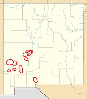
The Mogollon-Datil volcanic field is a huge area in western New Mexico. It's like a giant ancient volcano zone. This field covers about 40,000 square kilometers (15,000 sq mi). That's bigger than the country of Belgium!
This volcanic field is part of a much larger volcanic event. This event happened a long, long time ago. It took place during the Eocene and Oligocene periods. Other volcanic areas from this time include the San Juan volcanic field in Colorado. There's also the Trans-Pecos volcanic field in Texas. The Mogollon-Datil field formed in four main stages. These stages involved two separate groups of calderas working together.
How the Rocks Formed
Scientists have studied the rocks in the Mogollon-Datil volcanic field for many years. They want to understand how these rocks formed. The different layers of rock tell a story about the area's past.
Originally, all the volcanic rocks here were called the Datil Formation. Later, scientists grouped them differently. They added some related sedimentary rocks. These are rocks made from bits of other rocks, like sand or mud.
In 1994, new ideas helped scientists understand the rocks better. They divided the rocks into three main groups. These groups help us see how the volcanoes changed over time.
| Volcanic Units | Sedimentary Units | ||
|---|---|---|---|
| Mogollon Group |
tuff of Turkey Springs |
Spears Group |
South Crosby Peak Formation |
| lacuna (31.4-29.0 Ma) | |||
| Datil Group |
Tadpole Ridge Tuff |
||
Some rocks from the Vicks Peak and La Jencia Tuffs have been found far away. They were found in the Rio Puerco valley. This shows that the volcanic flows from the Mogollon-Datil field spread out very far. They even reached the northern edge of the younger Mount Taylor volcanic field.
Famous Calderas
A caldera is a large, bowl-shaped hollow. It forms when a volcano erupts and its magma chamber empties. The ground above then collapses. The Mogollon-Datil volcanic field has many of these impressive calderas. They are grouped into northern and southern complexes.
Northern Caldera Group
This group of calderas is found west of Socorro. It is also south of Magdalena. And it is southeast of Datil.
| Name | Associated tuff | Coordinates | Age |
|---|---|---|---|
| Socorro Caldera | Hells Mesa Tuff | 34°00′N 107°06′W / 34°N 107.1°W | 32 Ma |
| Sawmill Canyon Caldera | La Jencia Tuff | 34°00′N 107°18′W / 34°N 107.3°W | 28.7 Ma |
| Hardy Ridge Caldera | Lemitar Tuff | 33°54′N 107°18′W / 33.9°N 107.3°W | 28 Ma |
| Mount Withington Caldera | South Canyon Tuff | 33°48′N 107°30′W / 33.8°N 107.5°W | 27.4 Ma |
| Bear Trap Caldera | tuff of Turkey Springs | 33°45′N 107°36′W / 33.75°N 107.6°W | 24.3 Ma |
Southern Caldera Group
This group of calderas stretches from Las Cruces to Mogollon.
| Name | Associated tuff | Coordinates | Age |
|---|---|---|---|
| Nogal Caldera | Vicks Peak Tuff | 33°36′N 107°24′W / 33.6°N 107.4°W | 28.4 Ma |
| Organ Caldera |
Cueva Tuff |
32°30′N 106°45′W / 32.5°N 106.75°W | 32 Ma |
| Emory Caldera | Kneeling Nun Tuff Fall Canyon Tuff |
33°00′N 107°45′W / 33°N 107.75°W | 33 Ma |
| Twin Sisters Caldera | Tadpole Ridge Tuff Caballo Blanco Tuff |
33°00′N 108°15′W / 33°N 108.25°W | 31.4 Ma |
| Schoolhouse Mountain Caldera | – | 32°45′N 108°36′W / 32.75°N 108.6°W | 33.5 Ma |
| Mogollon Caldera (just one fragment in the Bursum Caldera wall) |
Cooney Tuff Fanney Rhyolite Apache Springs Tuff |
33°30′N 108°30′W / 33.5°N 108.5°W | 34.0 Ma |
| Bursum Caldera | Bloodgood Canyon Tuff | 33°30′N 108°30′W / 33.5°N 108.5°W | 28.0 Ma |
| Gila Cliff Dwellings Caldera | Davis Canyon Tuff Shelley Peak Tuff |
33°30′N 108°15′W / 33.5°N 108.25°W | 28.1 Ma |
Scientists sometimes find slight differences in the ages of these calderas. This can happen when different studies use different methods.
 | Emma Amos |
 | Edward Mitchell Bannister |
 | Larry D. Alexander |
 | Ernie Barnes |


