Monroe Creek (Tunkhannock Creek tributary) facts for kids
Quick facts for kids Monroe Creek |
|
|---|---|

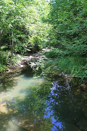
Monroe Creek looking downstream
|
|
| Other name(s) | Bartholomew Creek |
| Physical characteristics | |
| Main source | pond or small lake in Springville Township, Susquehanna County, Pennsylvania between 1,320 and 1,340 feet (402 and 408 m) |
| River mouth | Tunkhannock Creek in Nicholson Township, Wyoming County, Pennsylvania at Starkville 686 ft (209 m) 41°36′16″N 75°49′59″W / 41.6045°N 75.8330°W |
| Length | 6.1 mi (9.8 km) |
| Basin features | |
| Progression | Tunkhannock Creek → Susquehanna River → Chesapeake Bay |
| Basin size | 6.64 sq mi (17.2 km2) |
| Tributaries |
|
Monroe Creek, also known as Bartholomew Creek, is a small stream in Pennsylvania. It flows through Susquehanna County and Wyoming County. This creek is about 6.1 miles (9.8 km) long. It eventually flows into Tunkhannock Creek.
The land area that drains into Monroe Creek is about 6.64 square miles (17.2 km2). This creek is a healthy place for fish and other water creatures. It is known as a Coldwater Fishery and a Migratory Fishery.
Contents
Where Does Monroe Creek Flow?
Monroe Creek starts in a pond or small lake. This is in Springville Township, Susquehanna County. It flows generally south-southeast at first. Then it turns southwest and goes through a wetland.
The creek then turns south for over a mile. It passes through another wetland. Here, it enters Nicholson Township in Wyoming County. It then turns south-southeast. Along this part, two small streams join it from the right side.
After a short distance, it flows past Pompey Hill and Dam Hill. The creek then turns east and then south-southeast for a few miles. In this area, two more small streams join it from the left side. Finally, it turns south and crosses Pennsylvania Route 92. It then meets Tunkhannock Creek. Monroe Creek joins Tunkhannock Creek about 11.38 miles (18.31 km) before Tunkhannock Creek reaches its own end.
How Healthy is the Water?
Monroe Creek is considered a very healthy stream. It is not listed as a "polluted" or "impaired" water body. This means its water quality is good.
Land and Rocks Around the Creek
The land around Monroe Creek changes as you go along its path. Near where the creek joins Tunkhannock Creek, the ground is mostly made of alluvium. This is soil and sand left behind by flowing water. There are also alluvial terraces, which are flat areas formed by old floodwaters.
Further upstream, the ground also has alluvium. There is also a type of till called Wisconsinan Till. This is a mix of clay, sand, and rocks left by glaciers. Some nearby hills have bedrock made of sandstone and shale. These are types of rock formed over millions of years.
Near the creek's beginning, the land is mostly Wisconsinan Till. There is also a wetland right where the creek starts. The elevation at the mouth of Monroe Creek is about 686 feet (209 m) above sea level. The creek's source is higher, between 1320 and 1340 feet (402 and 408 m) above sea level.
Monroe Creek's Watershed
The watershed of Monroe Creek is the entire area of land where water drains into the creek. This area covers about 6.64 square miles (17.2 km2). The mouth of the creek is located in a place called Starkville.
The main purpose for Monroe Creek, as decided by environmental groups, is to support aquatic life. This means it's important for fish, insects, and other creatures that live in the water. In 2006, there was a plan to clean up flood debris in the creek.
History of Monroe Creek
Monroe Creek was officially added to the Geographic Names Information System on August 2, 1979. This system keeps track of names and locations of places in the United States. Its special ID number is 1192954.
The creek is also known by another name: Bartholomew Creek. This name was mentioned in a book from 1883. The book was about the geology of the Susquehanna River region.
A concrete bridge was built over Monroe Creek in 1931. This bridge carries Pennsylvania Route 92 in Nicholson Township. It is about 30.8 feet (9.4 m) long. As of 2013, this bridge needed repairs.
Biology and Fish
The watershed of Monroe Creek is a special place for fish. It is called a Coldwater Fishery. This means the water is cold enough for fish like trout to live there. It is also a Migratory Fishery. This means some fish travel through the creek as part of their life cycle.
 | Janet Taylor Pickett |
 | Synthia Saint James |
 | Howardena Pindell |
 | Faith Ringgold |


