Montebello, Antioquia facts for kids
Quick facts for kids
Montebello, Antioquia
|
|||
|---|---|---|---|
|
Municipality and town
|
|||

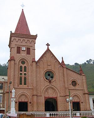
Church of Our Lady of Mercedes
|
|||
|
|||
| Nickname(s):
Miracle of the Mountains
|
|||

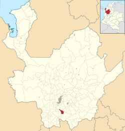
Location of the municipality and town of Montebello, Antioquia in the Antioquia Department of Colombia
|
|||
| Country | |||
| Department | |||
| Subregion | Southwestern | ||
| Founded | June 8th, 1876 | ||
| Area | |||
| • Municipality and town | 210 km2 (83 sq mi) | ||
| Elevation | 2,350 m (7,710 ft) | ||
| Population
(2018)
|
|||
| • Municipality and town | 6,680 | ||
| • Density | 31.07/km2 (80.5/sq mi) | ||
| • Urban | 1,866 | ||
| Time zone | UTC-5 (Colombia Standard Time) | ||
Montebello is a town and municipality in the Antioquia Department, Colombia. It is located high in the mountains, about 2,350 meters (7,710 feet) above sea level. Montebello is part of the Southwestern Antioquia region. It shares borders with towns like El Retiro to the north, Fredonia and Santa Bárbara to the west, Abejorral to the south, and La Ceja and El Retiro to the east.
Contents
History of Montebello
Early Beginnings
Along an old route used by Spanish explorers, a small village was started in 1619. It was first called Sabaletas. This village is now known as Montebello.
Montebello was first named Montebravo. Juan Antonio Ríos helped plan the town and changed its name to Montebello. People also called it "Nido de Águila," which means "Eagle's Nest."
Growth and Connection
Montebello is a small town today. It started growing more in 1941 when a road connected it to the town of La Pintada. This road helped Montebello connect with other areas.
The early history of Montebello's regions is not very clear. During the time of the Spanish conquest and colonial rule, Montebello was part of Sabaletas. Sabaletas was an important stop on the route between the regions of Antioquia and Popayán.
Becoming a Municipality
Sabaletas was part of Santiago de Arma. This area belonged to the province of Popayán until 1756. Then, a leader named Viceroy José Solís Folch de Cardona made it part of Antioquia.
The first Spanish explorers in these lands were led by Jorge Robledo. Later, the lands of Montebello were given to Jacinto de Arboleda.
In 1737, José Ubaldo Vásquez bought these lands. He later gave them to the people living in Arma.
For a long time, not much happened in Montebello's history. Then, in 1843, a church leader named Juan de la Cruz Gómez Plata visited Sabaletas. He ordered the church to be moved to a new spot. This caused a big discussion among the people. Many residents then moved to what is now the town center.
Around this time, the Council of La Ceja officially made Montebello a district. Twenty years later, on April 28, 1913, Montebello officially became a municipality. This happened when Clodomiro Ramírez was the governor of Antioquia.
Historical Sites
In the Sabaletas area, there is an old chapel. It is very beautiful and has a lot of history. In the countryside, you can find places like El Rodeo hill. There are also natural pools and waterfalls to explore.
About Montebello
Foundation and Nickname
Montebello was founded on June 8, 1619. It is called the "miracle of the mountains." This is because it was built in a very mountainous area that was hard to reach.
How to Get There
To reach Montebello, you can take the road towards Santa Bárbara. From Medellín, follow the road to Santa Bárbara. Then, you go up to Alto de Minas. At the village of Versalles, turn left onto the Zarcitos trail. This paved road is about 11.5 km long. The total distance from Medellín to Montebello's town center is 52.2 km.
From Pereira or Manizales, you can go to La Pintada. From there, continue to Santa Bárbara, then to the Versalles district. Here, you take the Zarcitos detour.
Another way to get to Montebello is from El Retiro. This road is unpaved and about 32 kilometers long. It passes by the La Miel and La Honda creeks. You can also reach Montebello from La Ceja using this unpaved road, passing through the San José district.
Milenio Stéreo Radio
Milenio Stéreo is a community radio station in Montebello. It has 200 watts of power. The station started broadcasting on December 12, 1997. It was given to the La Voz de Todos Broadcasting Corporation by the Ministry of Communications.
The radio station has a wide broadcast range. This is helped by the town's high altitude of 2350 meters above sea level.
Milenio Stéreo Coverage Areas
Milenio Stéreo reaches many areas. People have reported listening from these places:
- Southwest of Antioquia: Andes, Amagá, Betania, Betulia, Caldas, Caramanta, Ciudad Bolívar, Concordia, Damasco, Fredonia, Jardín, Jericó, La Pintada, Palermo, Pueblo Rico, Sabaletas, San Pablo, Santa Bárbara, Támesis, Tarso, Valparaíso, Versalles.
- Eastern Antioquia: La Ceja, El Retiro, La Unión, Abejorral.
- Chocó Department: Carmen de Atrato.
- Caldas Department: Aguadas, Anserma, Arma, Filadelfia, La Dorada, La Merced, Manizales, Marmato, Pácora, Chinchiná, and Tres Puertas.
Population of Montebello
Population Over Time
Montebello's population has changed over the years. Here is a look at its historical population:
| Year | Population | ±% |
|---|---|---|
| 1938 | 7,887 | — |
| 1951 | 8,529 | +8.1% |
| 1964 | 9,860 | +15.6% |
| 1973 | 9,063 | -8.1% |
| 1985 | 9,608 | +6.0% |
| 1993 | 9,953 | +3.6% |
| 2005 | 7,523 | -24.4% |
| 2018 | 6,680 | -11.2% |
Current Demographics
Montebello has a total population of 6,680 people. About 1,866 people live in the town area. The remaining 4,814 people live in the rural areas. In 2005, about 88.8% of the people could read and write. Most of the population (99.1%) are Mestizos and whites. A small part (0.6%) are Afro-Colombians, and 0.3% are indigenous people.
Montebello's Economy
Natural Resources
Montebello has a lot of plants and trees. It has large natural grasslands. Its mountains and hillsides offer many types of wood. This wood is used for building, making dyes, and furniture. Many medicinal plants also grow here.
The area is very rugged, with many hills and valleys. It has clear water from creeks like La Honda and the La Miel River. The La Miel River flows into the Buey River.
Main Industries
The local economy mostly depends on farming. Farmers grow a lot of coffee. They also grow plantains, avocados, beans, and corn. Some tobacco, cacao, and mango are grown too.
Raising animals is also important. People raise cattle, horses, mules, and pigs.
Mining is another key industry. Workers extract minerals like talc and feldspar from the ground.
Fun Places to Visit
- Church of Our Lady of Mercy: This beautiful church is located in the main town square.
- Chapel of Our Lady of Candelaria: You can find this old chapel in the Sabaletas district. It takes about 45 minutes to get there from the town center. It was built before 1700 and was declared a National Monument in 1984. It has been restored and looks great.
- Chapel in El Gavilán village: Another charming chapel to see.
- Agua Blanca Waterfall: This lovely waterfall is in the village of La Camelia.
- El Bramadero Museum: A museum to explore and learn about the area.
- El Rodeo Hill: You can reach this hill by an ecological trail. It offers some of the best views in the Antioquia department.
- Antique Museum: This museum is just 10 minutes from town, on the Versalles-Montebello road.
See also
 In Spanish: Montebello (Antioquia) para niños
 | Calvin Brent |
 | Walter T. Bailey |
 | Martha Cassell Thompson |
 | Alberta Jeannette Cassell |


