Moose Pass, Alaska facts for kids
Quick facts for kids
Moose Pass, Alaska
|
|
|---|---|

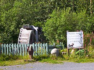
Water wheel and grindstone by side of Seward Highway. The sign reads: "Moose Pass is a peaceful little town, if you have an axe to grind, do it here."
|
|

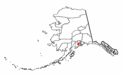
Location of Moose Pass, Alaska
|
|
| Country | United States |
| State | Alaska |
| Borough | Kenai Peninsula |
| Area | |
| • Total | 17.88 sq mi (46.31 km2) |
| • Land | 17.71 sq mi (45.88 km2) |
| • Water | 0.17 sq mi (0.43 km2) |
| Elevation | 472 ft (144 m) |
| Population
(2020)
|
|
| • Total | 228 |
| • Density | 12.87/sq mi (4.97/km2) |
| Time zone | UTC-9 (Alaska (AKST)) |
| • Summer (DST) | UTC-8 (AKDT) |
| ZIP code |
99631
|
| Area code(s) | 907 |
| FIPS code | 02-50190 |
| GNIS feature ID | 1417076 |
Moose Pass is a small community in Alaska, United States. It is called a census-designated place (CDP). This means it's an area that the government counts as a community for population studies, even if it's not officially a city or town. Moose Pass is located in the Kenai Peninsula Borough.
In 2020, about 228 people lived in Moose Pass. This number has grown a little over the years.
Contents
Where is Moose Pass Located?
Moose Pass is found in the northern part of the Kenai Peninsula in Alaska. It is surrounded by the huge Chugach National Forest, which is full of trees and wildlife.
The community is about 100 miles (160 km) south of Anchorage by road. It's also about 30 miles (48 km) north of Seward. You can reach Moose Pass by driving along the Seward Highway, which runs next to Upper Trail Lake.
Moose Pass Area and Nearby Roads
The Moose Pass area stretches about 8 miles (13 km) west along the Seward Highway. It reaches a point where the Seward Highway meets Alaska Route 1, also known as the Sterling Highway, near Tern Lake. From there, it's another 56 miles (90 km) west to Soldotna, which is the main town of the borough.
The total area of Moose Pass is about 17.88 square miles (46.3 square kilometers). Most of this area is land, with a small part being water.
What is the Climate Like in Moose Pass?
Moose Pass has a special kind of weather called a dry-summer continental subarctic climate. This means it has very cold, snowy winters and mild, somewhat dry summers.
The temperatures change a lot throughout the year. In winter, the average low can be around 8.7°F (-12.9°C) in January. In summer, the average high can reach about 65.6°F (18.7°C) in July.
It snows a lot in winter, with December often getting over 20 inches (50 cm) of snow. Summers are usually drier, but rain can still happen.
| Climate data for Moose Pass, Alaska (1991–2020 normals, extremes 1941–present) | |||||||||||||
|---|---|---|---|---|---|---|---|---|---|---|---|---|---|
| Month | Jan | Feb | Mar | Apr | May | Jun | Jul | Aug | Sep | Oct | Nov | Dec | Year |
| Record high °F (°C) | 58 (14) |
50 (10) |
59 (15) |
65 (18) |
80 (27) |
90 (32) |
89 (32) |
86 (30) |
73 (23) |
60 (16) |
53 (12) |
50 (10) |
90 (32) |
| Mean maximum °F (°C) | 42.7 (5.9) |
42.0 (5.6) |
46.9 (8.3) |
57.7 (14.3) |
70.8 (21.6) |
80.2 (26.8) |
82.1 (27.8) |
77.8 (25.4) |
65.7 (18.7) |
54.0 (12.2) |
44.5 (6.9) |
42.1 (5.6) |
83.6 (28.7) |
| Mean daily maximum °F (°C) | 23.7 (−4.6) |
28.8 (−1.8) |
34.5 (1.4) |
44.8 (7.1) |
55.1 (12.8) |
63.3 (17.4) |
65.6 (18.7) |
63.7 (17.6) |
54.8 (12.7) |
41.6 (5.3) |
30.1 (−1.1) |
26.9 (−2.8) |
44.4 (6.9) |
| Daily mean °F (°C) | 16.2 (−8.8) |
20.9 (−6.2) |
24.4 (−4.2) |
35.7 (2.1) |
44.6 (7.0) |
52.6 (11.4) |
56.2 (13.4) |
54.2 (12.3) |
46.2 (7.9) |
34.5 (1.4) |
23.7 (−4.6) |
19.5 (−6.9) |
35.7 (2.1) |
| Mean daily minimum °F (°C) | 8.7 (−12.9) |
12.9 (−10.6) |
14.2 (−9.9) |
26.5 (−3.1) |
34.0 (1.1) |
42.0 (5.6) |
46.8 (8.2) |
44.8 (7.1) |
37.7 (3.2) |
27.4 (−2.6) |
17.4 (−8.1) |
12.1 (−11.1) |
27.0 (−2.8) |
| Mean minimum °F (°C) | −15.9 (−26.6) |
−10.4 (−23.6) |
−8.7 (−22.6) |
11.6 (−11.3) |
26.1 (−3.3) |
32.8 (0.4) |
39.0 (3.9) |
34.5 (1.4) |
25.1 (−3.8) |
11.7 (−11.3) |
−3.9 (−19.9) |
−11.7 (−24.3) |
−22.7 (−30.4) |
| Record low °F (°C) | −43 (−42) |
−48 (−44) |
−30 (−34) |
−17 (−27) |
15 (−9) |
24 (−4) |
29 (−2) |
27 (−3) |
13 (−11) |
−10 (−23) |
−21 (−29) |
−37 (−38) |
−48 (−44) |
| Average precipitation inches (mm) | 3.46 (88) |
5.25 (133) |
2.16 (55) |
2.27 (58) |
2.10 (53) |
1.74 (44) |
2.43 (62) |
3.76 (96) |
6.04 (153) |
5.41 (137) |
4.23 (107) |
3.35 (85) |
42.20 (1,072) |
| Average snowfall inches (cm) | 13.9 (35) |
10.7 (27) |
12.2 (31) |
3.2 (8.1) |
0.0 (0.0) |
0.0 (0.0) |
0.0 (0.0) |
0.0 (0.0) |
trace | 3.5 (8.9) |
13.6 (35) |
20.7 (53) |
77.8 (198) |
| Average precipitation days (≥ 0.01 in) | 10.6 | 8.6 | 8.2 | 7.2 | 6.8 | 6.0 | 7.4 | 10.6 | 11.6 | 11.4 | 10.0 | 11.4 | 109.8 |
| Average snowy days (≥ 0.1 in) | 6.8 | 4.7 | 4.0 | 1.6 | 0.0 | 0.0 | 0.0 | 0.0 | 0.0 | 1.6 | 4.8 | 7.1 | 30.6 |
| Source 1: NOAA (precip days, snow/snow days 1981–2010) | |||||||||||||
| Source 2: National Weather Service | |||||||||||||
Population of Moose Pass Over Time
| Historical population | |||
|---|---|---|---|
| Census | Pop. | %± | |
| 1940 | 84 | — | |
| 1950 | 70 | −16.7% | |
| 1960 | 136 | 94.3% | |
| 1970 | 53 | −61.0% | |
| 1980 | 76 | 43.4% | |
| 1990 | 81 | 6.6% | |
| 2000 | 206 | 154.3% | |
| 2010 | 219 | 6.3% | |
| 2020 | 228 | 4.1% | |
| U.S. Decennial Census | |||
Moose Pass was first counted in the U.S. Census in 1940. Back then, it was just a small village. In 1980, it became a census-designated place (CDP).
According to the 2000 census, there were 206 people living in Moose Pass. There were 84 households, which are groups of people living together in one home.
The population has grown steadily since then. By 2020, the number of people living in Moose Pass had reached 228.
See also
 In Spanish: Moose Pass para niños
 | James Van Der Zee |
 | Alma Thomas |
 | Ellis Wilson |
 | Margaret Taylor-Burroughs |

