Morinish, Queensland facts for kids
Quick facts for kids MorinishQueensland |
|||||||||||||||
|---|---|---|---|---|---|---|---|---|---|---|---|---|---|---|---|

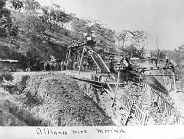
Alliance Mine in operation at Morinish, circa 1890
|
|||||||||||||||
| Population | 62 (2021 census) | ||||||||||||||
| • Density | 0.0820/km2 (0.212/sq mi) | ||||||||||||||
| Postcode(s) | 4702 | ||||||||||||||
| Area | 756.3 km2 (292.0 sq mi) | ||||||||||||||
| Time zone | AEST (UTC+10:00) | ||||||||||||||
| Location |
|
||||||||||||||
| LGA(s) | Rockhampton Region | ||||||||||||||
| State electorate(s) | Mirani | ||||||||||||||
| Federal Division(s) | Flynn | ||||||||||||||
|
|||||||||||||||
Morinish is a quiet rural area in Queensland, Australia. It is part of the Rockhampton Region. In 2021, about 62 people called Morinish home.
Contents
Where is Morinish?
Morinish is surrounded by nature. The Fitzroy River forms its northern and western borders.
A stream called Ten Mile Creek starts in the south-west of Morinish. It then flows north through the area. Eventually, it joins the larger Fitzroy River.
The old town of Morinish used to be located in the southern part of the area.
A Glimpse into History
Morinish has an exciting past, especially because of gold!
The Gold Rush
Gold was first discovered in Morinish in 1866. By December of that year, miners were already working hard. In February 1867, newspapers reported a "new rush" to the area. It was estimated that about 600 people had come to find their fortune.
A Post Office opened in Morinish on 1 July 1867. However, it closed a few years later on 4 November 1872.
Between the 1880s and 1900s, there were at least three big mines. These included the Welcome Reef, Alliance Mine, and Mount Morinish Mine.
Schools in Morinish
Because of the changing luck on the goldfields, schools in Morinish opened and closed often.
- The first Morinish Provisional School opened around 1882. It closed about eight years later, around 1890.
- Another Morinish Provisional School opened around 1894. It closed around 1897. We don't know if this was the same school reopening or a new one.
In 1902, two new provisional schools started: Morinish No 1 and Morinish No 2. These were "half-time" schools. This meant they shared one teacher between them.
In 1915, the No 2 school closed. The No 1 school then became a full-time school called Morinish State School. It closed in 1928 because there were not enough students. Two years later, in 1930, the school building was moved to Garnant to start a new State School there.
Another school, Ten Mile Creek Provisional School, opened in 1916. But it only stayed open for about a year, closing around 1917.
Morinish used to be part of the Shire of Fitzroy. In 2008, different local government areas joined together. Morinish then became part of the new Rockhampton Region.
Education Today
There are no schools located directly in Morinish now. The closest primary school is Ridgelands State School. It is in Ridgelands, which is a nearby area to the west.
For high school, the nearest government option is Rockhampton State High School. This school is in Wandal, a suburb of Rockhampton. However, it is quite far away. Because of this, students might choose other ways to learn. These include distance education (learning from home) or going to a boarding school.
Famous People
- Fergus McMaster, one of the people who helped start the airline Qantas, was born in Morinish.
 | DeHart Hubbard |
 | Wilma Rudolph |
 | Jesse Owens |
 | Jackie Joyner-Kersee |
 | Major Taylor |


