Morphett Vale, South Australia facts for kids
Quick facts for kids Morphett ValeAdelaide, South Australia |
|||||||||||||||
|---|---|---|---|---|---|---|---|---|---|---|---|---|---|---|---|

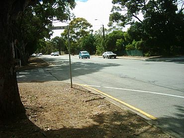
Wheatsheaf Road, facing east
|
|||||||||||||||
| Established | 1840 | ||||||||||||||
| Postcode(s) | 5162 | ||||||||||||||
| Area | 12.76 km2 (4.9 sq mi) | ||||||||||||||
| LGA(s) | City of Onkaparinga | ||||||||||||||
| Region | Southern Adelaide | ||||||||||||||
| County | Adelaide | ||||||||||||||
| State electorate(s) |
|
||||||||||||||
| Federal Division(s) | Kingston | ||||||||||||||
|
|||||||||||||||
Morphett Vale is a large suburb located south of Adelaide, South Australia. It's part of the City of Onkaparinga. With over 23,000 people, it's the biggest suburb in South Australia! It covers an area of about 12.76 square kilometers and has around 1,000 businesses.
Morphett Vale is surrounded by other suburbs. These include Sheriffs/Pimpala Road, Panalatinga Road, Doctors/Beach Road, and the Southern Expressway.
Contents
History of Morphett Vale
Morphett Vale was one of the first big towns south of Adelaide. It started in October 1840 when a town called Dublin was divided up. By 1866, people described it as having "many neat homes, often with nice vineyards attached."
The town was named after John Morphett. Early Morphett Vale quickly grew to have churches, a brewery, a wind flour mill, a court house, and a police station.
Farmers in the area grew cereals and had mixed farms and vineyards. In 1852, the Morphett Vale District Council was formed. It later joined with Noarlunga in 1932. During World War II, the area was important for growing flax.
In the 1960s, a lot of land was divided up for new homes. This changed Morphett Vale from a farming area into a modern suburb.
Some old buildings still stand today. The Heritage-listed Old Courthouse can be seen near early churches on William Street. The Emu winery used to be here but was replaced by Wirreanda High School and new houses.
The Willunga railway line used to run through the town until 1969. Now, that old railway path is used for bicycles and walking. The old Station Master's Residence is now the Southern Districts Workingman's Club.
Country Fire Service (CFS)
The Morphett Vale CFS station is located on Doctors Road and States Road in Hackham. This fire brigade is made up entirely of volunteers. They have about 50 active firefighters and also volunteers who help with support duties. There are also about 9 cadets learning the ropes.
This brigade is one of the busiest in South Australia. They respond to between 300 and 400 emergencies every year. The main areas they cover include Morphett Vale, Hackham, Onkaparinga Hills, Reynella, and Woodcroft. These areas have about 25,000 residents, plus industrial zones and large rural areas.
The Morphett Vale CFS brigade has three main fire trucks, called appliances. The Morphett Vale Pumper and Morphett Vale 34 are provided by the government. The Morphett Vale QRV was designed and built by the volunteers themselves.
Morphett Vale Pumper
This truck is the main vehicle for responding to fires in towns and cities. It was delivered in December 2011. It has a 2000-liter water tank and a powerful pump. It also has a foam tank to help put out fires.
Morphett Vale 34
This truck is built on a four-wheel drive chassis and carries 3000 liters of water. It has a strong pump that can deliver water at high pressure and volume at the same time.
Morphett Vale Quick Response Vehicle (QRV)
This vehicle is used for quick responses, especially in rural areas. It's built on a utility vehicle and has a 350-liter water tank. It uses a special system called CAFS (Compressed Air Foam System). This system makes high-quality foam using very little water and foam concentrate. With CAFS, they can produce foam for over 10 minutes using only 400 liters of water. Normal pumps would use much more water for the same result!
Schools in Morphett Vale
Morphett Vale has many schools for students of all ages.
Primary Schools
- Antonio Catholic School
- Calvary Lutheran School
- Coorara Primary School
- Flaxmill Primary School
- Morphett Vale Primary School (This used to be Morphett Vale High School)
- Morphett Vale East Primary School
- Morphett Vale West Primary School
- Pimpala Primary School
- Stanvac Primary School
- Sunrise Christian School
- John Morphett Primary School
R-12 Schools
These schools teach students from Reception (the first year of primary school) all the way through to Year 12 (the last year of high school).
- Prescott College Southern
- Southern Vales Christian College
- Woodcroft College
Secondary Schools
- Wirreanda High School
Former Schools in the Area
In 2000, Morphett Vale South Primary School closed. The land where it stood is now a housing estate. Morphett Vale High School closed at the end of 2008. After some community discussion, the school was renovated and reopened as a primary school in 2012. Its oval is still used for local sports.
Sporting Clubs and Grounds
Morphett Vale has many sporting clubs and grounds for different activities.
- Morphett Vale Memorial Bowls Club – Located at Morphett Vale Memorial Oval, Wheatsheaf Road
- Morphett Vale Football Club – Plays at Morphett Vale Memorial Oval, Wheatsheaf Road
- Morphett Vale Tennis Club – Found at Morphett Vale Memorial Oval, Wheatsheaf Road
- Morphett Vale Netball Club – Also at Morphett Vale Memorial Oval, Wheatsheaf Road
- Noarlunga Tigers Basketball Club – Plays at Wilfred Taylor Reserve, States Road
- Noarlunga United Soccer Club – Plays at Wilfred Taylor Reserve, States Road
- O'Sullivan Beach-Lonsdale Football Club – Home ground is Morphett Vale Primary School, Sheriffs Road
- Onkaparinga Rugby Club – Plays at Wilfred Taylor Reserve, States Road
 | Roy Wilkins |
 | John Lewis |
 | Linda Carol Brown |

