Motherwell (district) facts for kids
| Motherwell | |
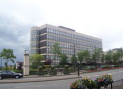
 Civic Centre, Windmillhill Street, Motherwell |
|
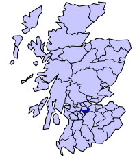
 Motherwell district within Scotland |
|
| Geography | |
| Status | District |
| HQ | Motherwell |
| History | |
| Created | 16 May 1975 |
| Abolished | 31 March 1996 |
| Succeeded by | (Part of) North Lanarkshire |
Quick facts for kids Demography |
|
|---|---|
| 1994 population | 143,730 |
| Politics | |
| Governance | Motherwell District Council |
Motherwell (in Scottish Gaelic: Tobar na Màthar, in Scots: Mitherwall or Murwall) was a special area in Scotland that had its own local government. It was called a "district" and existed from 1975 to 1996. Motherwell district was part of a larger area called the Strathclyde region. It was located southeast of Glasgow, which was the main city of that region.
Contents
History of Motherwell District
How the District Was Created
The Motherwell district was formed in 1975. This happened because of a new law called the Local Government (Scotland) Act 1973. This law changed how local areas were managed across Scotland. It created two main levels of local government. There were larger "regions" and smaller "districts" within them.
Motherwell was one of 19 districts made inside the Strathclyde region. The new Motherwell district took over parts of three older areas. These older areas were from the historic county of Lanarkshire. They included the towns of Motherwell and Wishaw, plus parts of what were known as the Sixth and Seventh Districts.
Where Motherwell District Was Located
The district was named after its biggest town, Motherwell. The River Clyde formed its western border. Most of its northern border was along the North Calder Water.
Besides Motherwell itself, the district also included several other towns. These were Bellshill, Chapelhall, Holytown, Newarthill, Newmains, and Viewpark. There was also a countryside area around the small town of Shotts. This area stretched east to the border with West Lothian. Motherwell district was quite large, having the eighth-biggest population out of 53 districts in Scotland at that time.
When the District Ended
The Motherwell district stopped existing in 1996. This was due to another new law, the Local Government etc. (Scotland) Act 1994. This law changed Scotland's local government system again. It replaced the regions and districts with new, single "council areas."
The North Lanarkshire council area was created at this time. It took over the areas that used to be Motherwell district. It also included the former districts of Monklands and Cumbernauld and Kilsyth. A small part of the Strathkelvin district, called Chryston, also joined North Lanarkshire.
Political Control
Who Ran the Council
The first election for the Motherwell District Council happened in 1974. At first, this new council worked alongside the old local authorities. It officially started its duties on May 16, 1975.
Throughout the entire time the Motherwell District Council existed, the Labour party was in charge. They always had more than half of the seats on the council. This meant they could make most of the decisions.
| Party in Control | Years | |
|---|---|---|
| Labour | 1975–1996 | |
Council Buildings
The Motherwell District Council had its main office at the Motherwell Civic Centre. This building is on Windmillhill Street in Motherwell. It was built between 1965 and 1970 for the council that existed before, the Motherwell and Wishaw Town Council. After the Motherwell district council was abolished in 1996, the building became the main office for the new North Lanarkshire Council.
See also
- 1992 Motherwell District Council election
- Subdivisions of Scotland
 | James Van Der Zee |
 | Alma Thomas |
 | Ellis Wilson |
 | Margaret Taylor-Burroughs |

