Mount Alice (Falkland Islands) facts for kids
Quick facts for kids Mount Alice |
|
|---|---|
| Highest point | |
| Elevation | 361 m (1,180 ft) |
| Prominence | 361 m (1,180 ft) |
| Geography | |
| Location | Falkland Islands, South Atlantic Ocean |

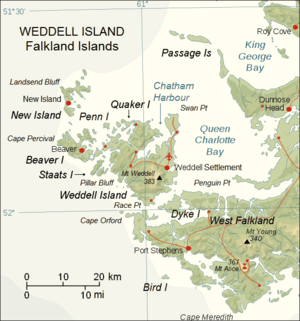
Mount Alice is a mountain located in the Falkland Islands. It's a tall peak, reaching 361 m (1,180 ft) (about 1,184 feet) high. You can find it at the very south end of West Falkland, between two bays called Port Stephens and Port Albemarle. It's about 12.3 km (7.6 mi) north of Cape Meredith.
Mount Alice: A Key Location
Mount Alice is more than just a mountain; it plays an important role in protecting the skies.
Protecting the Skies: Radar Station
After the Falklands War, Mount Alice became home to a special unit of the Royal Air Force (RAF) called No. 751 Signals Unit. Their job was to operate a radar system that helped watch the skies for any aircraft.
Today, the very top of Mount Alice has a Remote Radar Head (RRH). This is like a giant eye that helps the British Forces South Atlantic Islands (BFSAI) keep an eye on the airspace. It's part of a bigger network that helps give early warnings and control air traffic. Other similar radar stations are located at RRH Byron Heights on West Falkland and RRH Mount Kent on East Falkland. Together, these stations help keep the Falkland Islands safe.
 | Madam C. J. Walker |
 | Janet Emerson Bashen |
 | Annie Turnbo Malone |
 | Maggie L. Walker |


