Mount Cameron (Alaska) facts for kids
Quick facts for kids Mount Cameron |
|
|---|---|

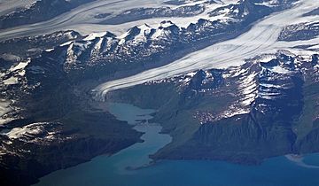
Mt. Cameron centered near top of frame
(Mount Hogan to right of Shoup Glacier) |
|
| Highest point | |
| Elevation | 5,360 ft (1,630 m) |
| Prominence | 1,210 ft (370 m) |
| Isolation | 4.5 mi (7.2 km) |
| Geography | |
| Location | Valdez-Cordova Borough Alaska, United States |
| Parent range | Chugach Mountains |
| Topo map | USGS Valdez A-8 |
Mount Cameron is a mountain in Alaska, United States. It stands about 5,360 feet (1,634 meters) tall. This peak is part of the Chugach Mountains. It is located about 15 miles (24 km) northwest of Valdez, Alaska. The mountain is also on the edge of the Chugach National Forest.
Even though it's not the tallest mountain, Mount Cameron looks very impressive. Its southern side rises sharply from the water. This water is part of Shoup Bay in Prince William Sound. The mountain climbs over 4 miles from the sea. Local gold miners gave the mountain its name. This was reported in 1912 by the U.S. Geological Survey.
Understanding Mount Cameron's Climate
Mount Cameron has a subarctic climate. This means it has long, cold, and snowy winters. The summers are usually mild. This type of climate is found in areas just south of the Arctic. Scientists use the Köppen climate classification system to describe climates like this.
Weather systems often come from the Gulf of Alaska. When these systems reach the Chugach Mountains, they are forced to rise. This process is called orographic lift. As the air rises, it cools down. This cooling causes a lot of rain and snow to fall on the mountains.
Temperatures around Mount Cameron can drop very low. They might go below -20 °C (-4 °F). With wind, it can feel even colder, sometimes below -30 °C (-22 °F). This cold climate helps create and keep large glaciers. The Shoup Glacier is on the east side of the mountain. The huge Columbia Glacier is to the west.
 | Calvin Brent |
 | Walter T. Bailey |
 | Martha Cassell Thompson |
 | Alberta Jeannette Cassell |


