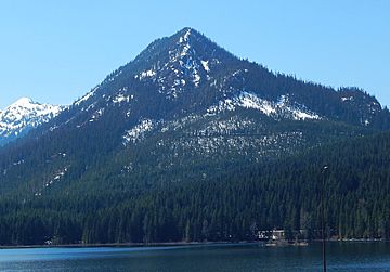
Mount Catherine (Washington) facts for kids
Quick facts for kids Mount Catherine |
|
|---|---|

Mount Catherine
|
|
| Highest point | |
| Elevation | 5,052 ft (1,540 m) NGVD 29 |
| Prominence | 1,212 ft (369 m) |
| Geography | |
| Location | Kittitas County, Washington, U.S. |
| Parent range | Cascades |
| Topo map | USGS Lost Lake |
Mount Catherine is a mountain peak in the Cascade Range in Washington State. It's located near Snoqualmie Pass, a well-known mountain pass, and Keechelus Lake. This mountain is a popular spot for outdoor fun.
You can usually reach Mount Catherine by car, but the road closes in winter. During the snowy months, many people enjoy snowshoeing or climbing up its slopes. A popular snowshoe trail, called the Nordic Pass trail, leads to a spot on the mountain's west side. From there, experienced climbers often continue to the very top! This area is close to the Summit East ski area.
Weather and Climate
Mount Catherine is in a special weather zone called the marine west coast climate. This means it gets a lot of moisture from the Pacific Ocean. Most of the weather systems start over the Pacific. They then travel northeast towards the Cascade Mountains.
How Mountains Make Rain and Snow
When these weather systems hit the tall peaks of the Cascade Range, they are forced to rise. As the air goes higher, it cools down. This cooling makes the moisture in the air turn into rain or snow. That's why the west side of the Cascades gets so much precipitation, especially snow in winter!
Temperatures and Snow
Because it's close to the ocean, the temperatures around Mount Catherine are usually mild. It rarely gets colder than 0°F (about -18°C) or hotter than 80°F (about 27°C). In winter, it's often cloudy. But in summer, high-pressure systems over the Pacific Ocean bring clear, sunny skies. The snow here tends to be wet and heavy. This can sometimes lead to a higher risk of avalanches, so safety is always important for winter adventurers.
 | Jessica Watkins |
 | Robert Henry Lawrence Jr. |
 | Mae Jemison |
 | Sian Proctor |
 | Guion Bluford |

