Mount Drum facts for kids
Quick facts for kids Mount Drum |
|
|---|---|

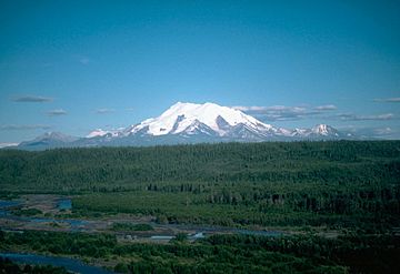
Mount Drum from the northwest
|
|
| Highest point | |
| Elevation | 12,010 ft (3,660 m) |
| Prominence | 6,710 ft (2,050 m) |
| Listing |
|
| Geography | |
| Location | Wrangell-St. Elias National Park and Preserve, Alaska, U.S. |
| Parent range | Wrangell Mountains |
| Topo map | USGS Gulkana A-2 |
| Climbing | |
| First ascent | 1954 by Heinrich Harrer, Keith Hart, George Schaller |
Mount Drum is a large stratovolcano (a cone-shaped volcano built up by many layers of hardened lava and ash) located in the Wrangell Mountains of east-central Alaska, United States. It sits at the far western edge of the Wrangell Mountains. This impressive mountain is about 18 miles (29 km) west-southwest of Mount Sanford and the same distance west-northwest of Mount Wrangell. Mount Drum is also found just inside the western border of Wrangell-Saint Elias National Park and Preserve, about 25 miles (40 km) east of the Copper River.
Contents
Discovering Mount Drum's Location
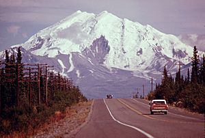
Mount Drum stands tall near the low valley of the Copper River. It is famous for how much it rises from the land around it. This is called its "local relief."
How High Does Mount Drum Rise?
For example, the south side of Mount Drum climbs 6,000 feet (1,830 m) above the Nadina Glacier in just 1.6 miles (2.6 km). Its western slopes rise 9,000 feet (2,743 m) above the flat tundra in only 10 miles (16 km). It even rises 11,000 feet (3,353 m) above the Copper River in just 25 miles (40 km). These numbers are similar to other well-known volcanoes like Mount Rainier and Mount Shasta. However, Mount Drum is not as tall as its neighbor, Mount Sanford, which is also in Alaska.
The History of Mount Drum's Geology
Mount Drum was an active volcano a very long time ago. It was active between 650,000 and 240,000 years ago.
How Mount Drum Changed Over Time
During its later active period, several separate dacitic domes (small, rounded hills formed by thick lava) grew in a circle around the main peak. These domes were about 4 miles (6 km) away from the center. One of these domes is now Snider Peak, which is 8,250 ft or 2,515 m tall and located south of the main peak.
After this building phase, there was a huge explosive eruption. This explosion likely came from the center of the volcano. It destroyed the southern half of the stratovolcano. This event spread about 7 cubic kilometers of hot and cold rock and debris over an area larger than 200 square kilometers. You can still see the results of this powerful explosion in the very steep south face of Mount Drum, above the Nadina Glacier.
Mud Volcanoes Near Mount Drum
On the west side of Mount Drum, there are the Shrub and Klawasi mud volcanoes. In recent history, the only activity near Mount Drum has been mud and gas coming out of these mud volcanoes.
Climbing Mount Drum

Mount Drum was first climbed on June 4, 1954. The famous Austrian mountaineer Heinrich Harrer was part of this first team, along with Keith Hart and George Schaller. They climbed the North Ridge.
Popular Climbing Routes
The second time someone climbed Mount Drum was on August 26, 1968. Heinz Allemann and Niklaus Lötscher made this ascent using the Southwest Ridge. This Southwest Ridge is now the most common way to climb the mountain. It is rated as Alaska Grade 2+, which means it's a challenging but achievable climb for experienced mountaineers.
See also
 In Spanish: Monte Drum para niños
 | James Van Der Zee |
 | Alma Thomas |
 | Ellis Wilson |
 | Margaret Taylor-Burroughs |


