Snider Peak facts for kids
Quick facts for kids Snider Peak |
|
|---|---|

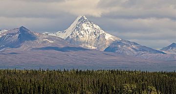
Snider Peak seen from Richardson Highway
|
|
| Highest point | |
| Elevation | 8,250 ft (2,510 m) |
| Prominence | 1,200 ft (370 m) |
| Isolation | 3.02 mi (4.86 km) |
| Parent peak | Mount Drum |
| Geography | |
| Location | Wrangell-St. Elias National Park Valdez-Cordova Borough Alaska, United States |
| Parent range | Wrangell Mountains |
| Topo map | USGS Gulkana A-2 |
| Type of rock | Dacite |
Snider Peak is a tall mountain in Alaska, United States. It stands at 8,250 feet (2,515 meters) high. This peak is part of the amazing Wrangell Mountains. It's also located inside the huge Wrangell–St. Elias National Park and Preserve, which is a protected area.
Snider Peak is about 30 miles (48 km) east of a town called Glennallen. It's also quite close to Mount Drum, which is an even taller mountain just 3 miles (5 km) to the north. Water from Snider Peak flows into the Dadina and Nadina Rivers. These rivers then join the larger Copper River. The name "Snider Peak" might come from an early explorer or prospector, as noted by the US Geological Survey way back in 1903.
Weather at Snider Peak
The weather around Snider Peak is known as a subarctic climate. This means it has very long, cold, and snowy winters. The summers, however, are usually mild.
Weather systems often come from the Gulf of Alaska. When these systems hit the tall Wrangell Mountains, they are forced to rise. This process is called orographic lift. As the air rises, it cools down and creates a lot of rain and snow.
Temperatures in this area can get super cold, sometimes dropping below −20 °F (−29 °C). With the wind chill, it can feel even colder, below −30 °F (−34 °C)! If you want to visit or climb Snider Peak, the best time is usually from May through June. The weather is most pleasant during these months for outdoor activities.
 | Charles R. Drew |
 | Benjamin Banneker |
 | Jane C. Wright |
 | Roger Arliner Young |


